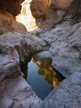
Rattlesnake Canyon (San Carlos Indian Reservation)
| Rating: | |||||||||||||||||||||||||||||||
|---|---|---|---|---|---|---|---|---|---|---|---|---|---|---|---|---|---|---|---|---|---|---|---|---|---|---|---|---|---|---|---|
| | Difficulty:2A IV (v1a1 IV) Raps:0
Red Tape:Permit required Shuttle:None Vehicle:High Clearance | ||||||||||||||||||||||||||||||
| Location: | |||||||||||||||||||||||||||||||
| Condition Reports: | |||||||||||||||||||||||||||||||
| Best season: | winter, spring, fall
|
||||||||||||||||||||||||||||||
| Regions: | |||||||||||||||||||||||||||||||
Introduction[edit]
A nice, long, non-technical canyon hike with some good, but short sections of narrows.
A permit is required to hike in this area from the San Carlos Apache tribe, the easiest way to acquire said permit for this area seems to be to simply stop off at a specific Circle K location in Globe, AZ and buy one. This makes the approach driving directions a little out of the way, but not much (adds about half an hour).
From Phoenix, drive east on US60 through Superior and Globe, staying straight to continue onto US70, to shortly thereafter stop off at the last Circle K in Globe located on the left at 33.384142, -110.755893. After securing permits, continue east on US70, then turn right onto SR77 south towards Tucson. After 35.7 miles turn left onto an unsigned dirt road just after milepost 132. Some maps may call this Leadville St, and there is a road signed as Leadville St before the correct turn, but this only goes to a residence - do not turn on the road signed as Leadville. To add to the confusion, other maps call this road Kellys Camp Trail or simply "300", and it may or may not be signed as such - milepost 132 - that's the thing to look for. Drive on this dirt road (whatever it is) for 8.4 miles, ignoring the many minor branching roads along the way to turn left towards a large stand-alone rock outcrop called Eskiminzin Fort Rock on the map. This more minor road degrades more and more the farther it goes, but can be driven for a ways or you can choose to park at or near the rock and hike the rest of the way - continuing to drive might only get you another half a mile or so before the road becomes impassable - park where you see fit.
Approach[edit]
From Eskiminzin Fort Rock, continue hiking down the road to the north for about a mile to eventually reach an old ranch called Lion Camp at the edge of Ash Creek. Turn right to hike up along the banks of Ash Creek for about .25 mile to reach an obvious, large break in the cliffs through a drainage on your left (north). There are many ways up this brushy, rocky drainage, none of them that much better than the rest, get up to the top however you can. The main objective here is to locate an old road on top that will take you to Rattlesnake Canyon; by sticking a bit to the left when hiking up the drainage you may find the road more quickly. Once the road is located, simply follow it as it travels easily northeast for about 3.3 miles to drop into one of the upper forks of Rattlesnake at 33.001543, -110.588446. When you see a small dam below to your right that seems to usually have a good amount of water in it, that's the point to break off from the road to your left to head down into this upper fork.
Descent[edit]
One small, scenic section of narrows is encountered in this upper fork that starts with a 15 foot drop that can be bypassed by hiking along the left side, then down into the slot at a lower angled spot. After a little less than a mile in this upper fork you will reach a confluence with another fork on the right which holds some interesting canyon features to explore - if you're so inclined. All of the narrows in this section can be hiked/climbed around without too much trouble. At the top of this short section is a beautiful, sculpted drop of roughly 70-80 feet (there's nothing above it- I looked), and below is an otherworldly, watery section of narrows with a roof of sculpted boulders above - very cool, but very short. I hiked around this to explore it from the bottom - going up and through this section requires a very, very cold swim. Two miles of boulder hopping and gravel hiking now stand before you and Ash Creek with a few nice sections of narrows in different layers of rock in between - one deep and winding section stands out as being quite nice. The are deep pools to hike around and some minor downclimbs, but nothing that requires much in the way of explanation - proceed down canyon.
Exit[edit]
Once you reach the confluence with Ash Creek, turn left to travel south along and through the creek (occasional light trails can be found) on your way back to Lion Camp for the exit. Ash Creek holds rewards of its own and was flowing with clear, cool water at my visit and had some nice sections of white slickrock and is lushly forested. After a little over 1.5 miles in Ash Creek, you will reach Lion Camp on your right, hike back up the remaining mile on the road back to your car.
Red tape[edit]
A San Carlos Apache recreational permit is required to hike or camp in this area for $10 per day.
