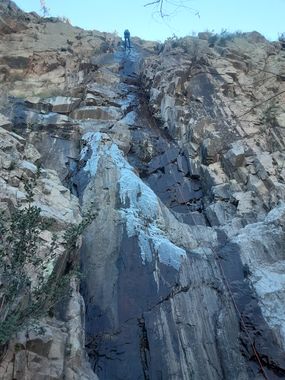
Replay Canyon
| Rating: | |||||||||||||||||||||||||||||||
|---|---|---|---|---|---|---|---|---|---|---|---|---|---|---|---|---|---|---|---|---|---|---|---|---|---|---|---|---|---|---|---|
| | Difficulty:3A II (v3a1 II) Raps:2-4, max ↨100ft
Red Tape:No permit required Shuttle:None Vehicle:Passenger | ||||||||||||||||||||||||||||||
| Start: | |||||||||||||||||||||||||||||||
| Parking: | |||||||||||||||||||||||||||||||
| Condition Reports: | 6 Feb 2022
"Approached via a ridgeline that runs parallel with the canyon. Brush was manageable and mostly forgiving. Some residual ice coating the walls of each |
||||||||||||||||||||||||||||||
| Best season: | Nov-Mar, After rains
|
||||||||||||||||||||||||||||||
| Regions: | |||||||||||||||||||||||||||||||
Introduction[edit]
A rugged canyon near Tonto Basin, AZ with a few rappels and several downclimbs. The northern-facing drainage receives minimal sun exposure during the wintertime, resulting in ice sheets developing on the vertical obstacles.
Approach[edit]
Dirt road from highway 188 to turn down to parking should be fine for passenger vehicle with good tires and driven carefully. All wheel drive vehicle probably preferred to park at trailhead down road that turns down.
Follow trail 66 until it crosses creek, about 1/4 mile. Head off trail up left. Follow ridge line up. Hike down slope into canyon.
Descent[edit]
R1: 50' off of cairn anchor. Optional downclimb LDC.
R2: 100' off of small tree LDC. Best rappel of canyon. Shear drop.
R3: 45' off of rock pinch RDC. Optional downclimb LDC.
R4: 30' off of tree LDC. Optional challenging downclimb.
Notable downclimb a few feet after R4. Some may want to rappel. About 10'.
Exit[edit]
Follow canyon down. Some downclimbs. When drainage starts getting overwhelmingly brushy, exit up LDC. Hike to connect with trail 66. Follow trail back to vehicle.
Red tape[edit]
Beta sites[edit]
Trip reports and media[edit]
Background[edit]
First known descent by Nick Clegg, Melissa Gibbons, Jacob Cowan, Cole Anderson, and Erek Burek on February 6, 2022.
