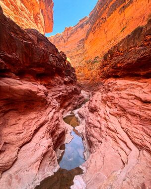
Rider Canyon
| Rating: | |||||||||||||||||||||||||||||||
|---|---|---|---|---|---|---|---|---|---|---|---|---|---|---|---|---|---|---|---|---|---|---|---|---|---|---|---|---|---|---|---|
| | Difficulty:3B III (v3a2 III) Raps:1, max ↨170ft
Red Tape:No permit required Shuttle:None Vehicle:4WD - High Clearance | ||||||||||||||||||||||||||||||
| Location: | |||||||||||||||||||||||||||||||
| Condition Reports: | 20 Apr 2025
"Fun canyon, however we failed to complete the entire canyon. Our party did only the upper section, which included some nice narrows and the single rap |
||||||||||||||||||||||||||||||
| Best season: | Fall;Winter;Spring
|
||||||||||||||||||||||||||||||
| Regions: | |||||||||||||||||||||||||||||||
Introduction[edit]
A scenic canyon with one big rappel which requires quite a bit of effort to access.
An alternate, non-technical approach is also described in Todd Martins book Grand Canyoneering.
Approach[edit]
14 miles of partially well-graded, partially sandy, and occasionally rocky forest road. 1-2h of driving from 89A to parking pin.
Road crosses multiple washes and may be impassable when wet.
Hike back along the road and then cross country to the drainage drop in point. About 3.5 miles.
Descent[edit]
Lots of downclimbs through large boulder fields, some scenic nontechnical narrows with deep pools, and one 170’ rappel.
Exit[edit]
After the one and only rappel, continue all the way to the mouth of House Rock Wash / Rider Canyon and then follow the KML track as it traverses downstream along the Colorado River and then ascends up to the rim.
Alternatively, exit earlier by taking the “hiker’s trail” / sneak exit back up the car park. Note: the first part of this exit traverses a significant amount of rockfall, is quite rugged, and the KML track for this section is only approximate. Eventually, a decent trail does develop (KML becomes more accurate) and switchbacks up to the rim. Towards the top of the exit gully large boulders have fallen and the only way through is via a couple small rabbit holes. Most should have no problem fitting through if packs are removed.
Red tape[edit]
Permits required for overnight use.
Beta sites[edit]
 Super Amazing Map : Rider Canyon
 CanyonChronicles.com : Rider Canyon
 Grand Canyoneering Book by Todd Martin : Rider Canyon -Upper
 ToddsHikingGuide.com : Rider Canyon
 Grand Canyoneering Book by Todd Martin : Rider Canyon -Trail
Trip reports and media[edit]
Gallery July 2, 2012 by Christian Lupercio
