Rock Creek (Olympic Peninsula)
| Rating: | |||||||||||||||||||||||||||||||
|---|---|---|---|---|---|---|---|---|---|---|---|---|---|---|---|---|---|---|---|---|---|---|---|---|---|---|---|---|---|---|---|
| | Raps:2-5, max ↨60ft
Red Tape:No permit required Shuttle:None Vehicle:Passenger | ||||||||||||||||||||||||||||||
| Location: | |||||||||||||||||||||||||||||||
| Condition Reports: | |||||||||||||||||||||||||||||||
| Best season: | Jul-Sept
|
||||||||||||||||||||||||||||||
| Regions: | |||||||||||||||||||||||||||||||
Introduction[edit]
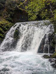
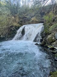
Rock Creek is a scenic canyon in the Olympic National Forest on the southeast corner of the Olympic Peninsula. After a bit of slippery creekwalking, the canyon features multiple rapid fire rappels into a steep valley leading to the South Fork Skokomish River. Run as a short/half day, or combine with nearby LeBar Creek or Fir Creek for a full day of canyoning.
Approach[edit]
From Hwy 101 north of Shelton, WA, turn left onto W Skokomish Valley Road, which eventually turns into FR 23. Drive about 11.4 miles from the highway to the parking area. Park at the pullout just west of the culvert where FR 23 crosses Rock creek (47.3743, -123.3172). Suit up here.
- Checkpoint is the falls coming out from under the bridge.
Descent[edit]
DCR = Down Canyon Right
DCL = Down Canyon Left
This canyon features numerous jumps. Always check pools for depth/debris before jumping! As of 2023, some pools in this canyon have been filled in with gravel and are shallower than in prior years.
- R0: For extra bonus points, rig from the guardrail and rappel off the bridge (~60ft). If you leave an anchor, please retrieve it when you return to your car. This rappel is a fun free-hang over the culvert, then down a short cascade. Alternately, find a small use trail on the downstream side of the culvert and walk into the creek.
- J1: Jump 8’ or downclimb. There is an abandoned truck upside down in the creekbed just after this drop.
- R1/J2: - Rappel 20' DCL from a tree. Alternatively, jump 12’ from DCR into a narrow hallway. This falls has crisscrossing jets of water, giving it the name "The Car Wash". If jumping, beware of sloping rock surface underwater on DCL. Stay close to the right side. This feature may also be bypassed by downclimbing far DCR.
- R2/J3: DCR - 35’ from a pair of bolts. This drop has been jumped by scrambling DCL to the lower tier - but take caution as the pool is shallow except for very specific areas.
- R3: Double bolts above the chute DCR - 12'. This bolt can be difficult to reach (there's a 8mm pulse hole for personal security). To avoid the recirculating current in the pool below, canyoneers must swim aggressively upon entering the water. Send a strong swimmer first. For less confident swimmers, having a teammate at the edge of the pool with a throw rope is recommended. As of 2025, this pot-hole can be jumped in moderate/low flow.
- R4/J4: DCL - 12' from a pair of bolt. Alternatively, shallow jump from the rim of the pothole DCR clear of the large log.
Immediately after the J4 pool, the canyon splits into two channels, offering different options for the final section of the canyon:
Option 1: The Mossy Wall
DCL: This is a multi-pitch rappel that keeps you in or alongside the flow. It is the preferred later season / lower flow route.
- R5a (1st pitch): 35' from unlinked bolts to a rebelay station / chain anchor. The rebelay anchor is DCR just over a lip obscured behind a rock knob. (It is possible to skip the rebelay for a 110' rappel to the bottom but this will require you to rappel in the flow. The rope pull may also be harder.)
- R5b (2nd Pitch): 60’ from the rebelay to the pool. This line allows you to rappel in or out of the flow.
Option 2: The Lagoon
DCR: This sequence drops you into a large, deep pothole, followed by a bolted rappel. When the canyon is flowing moderate or lower, this side of the canyon becomes a dry route, and the water in the pothole can become stagnant, making it a better early season route. Use caution at it may also become a keeper pothole that is difficult to escape as the water level drops.
- R6a / J5: (aka The Mosquito Pool): 40’ from a tree DCR into the pothole. This pothole can be jumped from the side (30') - the edges slope slightly, but the vast majority of it is upwards of 15' deep. Warning: this pool may be a keeper pothole in low water.
- R6b: 60' from a bolted Y-hang anchor DCR of the pothole, down a sloping chute to the bottom.
Exit[edit]
Just downstream of the final rappel, Rock Creek merges with Flat Creek (which is anything but flat) entering on the right via a small falls. The initial steepness of the exit is mercifully counterbalanced by the short distance back to the road.
To exit:
- Climb up flat creek, staying in the watercourse. It becomes thick with vegetation at times, but is mostly an easy scramble.
- After you've gone further than you think you should, look for a yellow forest service boundary sign slightly up the hillside on the right side of the creek, with pink flagging on top. This sign is quite low to the ground, and requires your team keeping an eye out for it. Nearby is some blue and pink flagging. At the sign, begin to switchback uphill.
- A dry, stripped log will allow you to traverse below a steep face - from that log, head uphill through steep scree along a social trail. From here, it's not far to the road.
- Walk the road back to the parking area.
Red tape[edit]
The canyon crosses briefly onto private timber land in the very last section of the canyon. The exit back to the main road brings you back into the Olympic National Forest.


