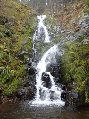
Rogers Creek NW
| Rating: | |||||||||||||||||||||||||||||||
|---|---|---|---|---|---|---|---|---|---|---|---|---|---|---|---|---|---|---|---|---|---|---|---|---|---|---|---|---|---|---|---|
| | Raps:4, max ↨150ft
Red Tape:No permit required Shuttle:Optional 1.2mi Vehicle:Passenger | ||||||||||||||||||||||||||||||
| Start: | |||||||||||||||||||||||||||||||
| Parking: | |||||||||||||||||||||||||||||||
| Shuttle: | |||||||||||||||||||||||||||||||
| Condition Reports: | 30 May 2024
"Fun shortie we paired with adjacent Rogers Ladder. I wouldnt run either of them individually and updated the map to show the link route which was bas |
||||||||||||||||||||||||||||||
| Best season: | Jan-May
|
||||||||||||||||||||||||||||||
| Regions: | |||||||||||||||||||||||||||||||
Introduction[edit]
Update 3/22/25: The road to Diamond Mill at Jones Creek is gated for logging. This may limit best access to the Rogers Creek area from Hwy 6.
A short tributary in the upper headwaters of Rogers Creek - about 1.5hrs from Portland. Not a bad one for the coast range with four rappels and a creek relatively free of brush. Approach and exit are pretty easy/straightforward. It's even faster with a shuttle. Best in the spring when it has water. Likely reduces to a trickle come May/June.
- A passenger vehicle can make it if driven carefully. High clearance may be preferred.
- Diehard canyoneers might consider running both Rogers Ladder and Rogers Creek NW in the same day. This double-feature was ran May 2024 and found to be a great combo. Exit up the slope immediately DCL after the NW trib. Substantial game trails (elk?) lead up to a bench in the slope that is visible on topo maps. Traverse east to the creek. After some creek walking downstream, the ladder begins.
- A good view point for determining flow has not yet been discovered.
Approach[edit]
Follow an old logging track down the northwest side of the ridge to drop into the creek a short distance above R1.
Descent[edit]
Use caution as the creek is excessively slippery.
- R1: 30ft+ from a tree DCL. Can rappel or downclimb the second tier.
- R2: 30ft from a tree DCL.
- R3: 150ft from a tree DCL. Falls is ~75ft high, but more rope is required per the horizontal distance. Bolts might allow one to run the flow directly on the way down.
- R4: 40ft from a tree DCL. Drop down a short chute that most of the creek funnels through.
Exit[edit]
Head downstream a short distance until the western tributary of Rogers Creek merges on the right. A short distance further, cross the creek to the south side and climb up into an old clearcut. Make your way up to an old track that makes a rising traverse up to the nose of the ridge. Once on the nose, break right and up to a track top the ridge and follow it to the road.
Red tape[edit]
None.
Beta sites[edit]
Trip reports and media[edit]
Background[edit]
First descended by Kevin Clark and Keith Langenwalter in April 2022.
