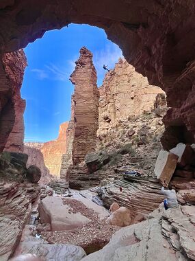
Royal Arch Creek
Jump to navigation
Jump to search
Also known as: Royal Arch Route.
| Rating: | |||||||||||||||||||||||||||||||
|---|---|---|---|---|---|---|---|---|---|---|---|---|---|---|---|---|---|---|---|---|---|---|---|---|---|---|---|---|---|---|---|
| | Difficulty:3B VI (v3a2 VI) Raps:max ↨170ft
Red Tape:Permit required Shuttle: Vehicle:4WD | ||||||||||||||||||||||||||||||
| Location: | |||||||||||||||||||||||||||||||
| Condition Reports: | 14 Dec 2025
"Beautiful canyon, south bass exit is great but the tonto trail was not my favorite. Huitzal is a great approach. Royal arch is slightly farther down t |
||||||||||||||||||||||||||||||
| Best season: | Spring;Fall
|
||||||||||||||||||||||||||||||
| Regions: | |||||||||||||||||||||||||||||||
Introduction[edit]
A rugged Grand Canyoneering route featuring a large natural bridge.
Approach[edit]
If approaching from land, Point Huitzil Trail is the most direct route to/from the arch.
South Bass Trail is also an option for a much longer trip.
Descent[edit]
R1: 170’ - rock pinch, down a mostly sheer wall
R2: 150’ - tree DCL, outside watercourse, mostly free hanging
R3: 30’ - tree DCR, avoids pool
After this there are a few downclimbs and many traverses DCL that avoid the drops in watercourse and keep you dry. One could opt to stay in water course and rig more drops, most of which are gently flowing into swimming pools.
Exit[edit]
Follow river for a ways eventually climbing up and out. There is a 20ft 5.8 climb to negotiate.
Red tape[edit]
Beta sites[edit]
 Super Amazing Map : Royal Arch Creek
 Grand Canyoneering Book by Todd Martin : Royal Arch Creek
 ToddsHikingGuide.com : Royal Arch Route
Trip reports and media[edit]
 Buzz Burrell on Canyon Tales : Royal Arch Loop
 Candition.com :
