Royal Gorge (Lower, Tahoe National Forest)
| Rating: | |||||||||||||||||||||||||||||||
|---|---|---|---|---|---|---|---|---|---|---|---|---|---|---|---|---|---|---|---|---|---|---|---|---|---|---|---|---|---|---|---|
| | Raps:1 + 5 jumps, max ↨100ft
Red Tape:No permit required Shuttle:Required 20 min Vehicle:High Clearance Rock type:Granite/mixed | ||||||||||||||||||||||||||||||
| Location: | |||||||||||||||||||||||||||||||
| Condition Reports: | |||||||||||||||||||||||||||||||
| Best season: | Jul-Aug
|
||||||||||||||||||||||||||||||
| Regions: | |||||||||||||||||||||||||||||||
Introduction[edit]
The lower Royal Gorge is a long, scenic river scramble in part of the North Fork American River, with several interesting technical obstacles spread out along its way. It is possible to do the canyon in a long day, but it is perhaps best done as an overnighter, and combined (in part or whole) with Upper Royal Gorge and/or Palisade Creek.
In high flows, the Royal Gorge is occasionally run as an extreme kayaking descent. Hikers have also worked their way up and down this lower section. It appears to be possible to hike next to the river for most of the way, bypassing all the obstacles, but it is not always possible to immediately get out (i.e., there are a couple of committing sections, described below).
The lower section of the Royal Gorge described here continues where Upper Royal Gorge leaves off, at the Palisade Creek bridge, and continues downstream to Wabena Creek.
Approach[edit]
From hwy 80, take the Soda Springs Rd exit. Follow Soda Springs Rd (a rough dirt road, best done with a high clearance vehicle) until you see a faded sign for "Palisades Creek Trail" next to an exit on the right. Take that exit and make camp, if you are driving out here at night. There is a fire ring and plenty of space. This is a primitive campsite (no water or bathrooms).
Set up the short car shuttle to the exit. You can start hiking from the campsite (0.5mi), or drive right to the start of the steep downhill part of Palisades Creek Trail. Continue down many switchbacks. At one point, the trail is washed out, and several fixed ropes aid you in handlining or rappelling 30' down into a drainage, and back out the other side.
Flow check Soon, you will approach the river at the bridge over the North Fork. Here, take a look upstream to assess the flow, and compare with the waterflow reference photo(s). Several obstacles in the canyon could be dangerous (as noted below) in flows significantly higher than Moderate.
There are stellar campsites right at the end of the approach, on both sides of the bridge. You will likely find other people camped here.
Descent[edit]
Note: Most obstacles in this canyon are jumped. As usual, it is prudent to send someone down on a meat anchor to check for depth and underwater obstructions. Also, on all jumps, make sure to get some distance away from the wall you're jumping from, as there may be some rocks closer to the wall, before hitting the deep area of the pool. All jumps should have fairly easy large landing zones.
Suit up and enter the river near the bridge.
Option: You can easily get to the last few features of Upper Royal Gorge from the bottom. Follow the trail you came down on until it starts going uphill, near some cairns. Enter the river here. Now, you can either go downstream, and do the Chockstone Jump and Ramp Jump, or go upstream all the way to the Fun Slide. Add 30-40min to your total time for this.
Palisade Falls - A few minutes downstream of the bridge, a jump of 35' (or more) described on the Upper Royal Gorge page. If members of your group are not comfortable with jumps of about 35', it is best to stay here and practice for a while until everyone is, because such jumps are mandatory downriver (unless you completely bypass all the fun sections).
Hike in the river for about a mile until it bends sharply left.
Little Curtain Falls - After a small drop (jump on either side), you enter a pool, where you swim right to the lip of the waterfall. A "beached whale" move gets you up a small boulder LDC. Jump from here, 25', and avoid the underwater ledges RDC. Note: In high flow, it will be dangerous to swim up to the falls, with risk of not being able to climb up the boulder and instead being swept over the falls. Jumping into the pool above Little Curtain Falls is committing - you may have no way out other than down the falls.
Next, there is a nice granite gorge, with several smaller jumps. "Cirque Creek", likely dry, joins the river from the RDC side. The river soon turns back into river hiking mode again for a while.
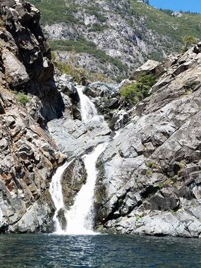
Petroglyph Falls - A two-stage waterfall, shown in the cover photo. The first drop is jumped from RDC, about 35'. After this jump, you are committed to the second drop, so make sure this looks doable from above before going in. A slippery climb takes you out of the pool RDC. Send down a decent climber first, in case others need help getting out of the pool. Next, cross the waterflow to the LDC side. This may be dangerous in high flow. Climb up a bit and find a ledge to jump from LDC, about 30'.
Another river hiking section, with a 20' jump thrown in (LDC of a small waterfall), leads you to the final obstacle.
Wabena Falls - A short slide takes you into a pool right above the falls. Climb out LDC, and find the bolted anchor high up on the wall. Rappel 100' into the pool below. This enjoyable rappel takes you along the edge and partially behind the waterfall.
Hike the river again, until you see a (likely dry) drainage come in from the left. This is Wabena Creek. Take off your wetsuit here.
Exit[edit]
Hike up the drainage, or up on the left (RDC) bank of it, until you see a large cairn RDC, and a short cascade in the creek. This marks the lower end of Wabena Creek Trail. Climb up on the left (RDC) side, past a second cairn. The trail continues uphill, mostly well marked by cairns. There is some poison oak along the way. Eventually, the trail crosses Wabena Creek (a good spot to refill water bottles) and continues steeply up the other side. Follow it back to your car.

