Salmon Creek (Lower)
| Rating: | |||||||||||||||||||||||||||||||
|---|---|---|---|---|---|---|---|---|---|---|---|---|---|---|---|---|---|---|---|---|---|---|---|---|---|---|---|---|---|---|---|
| | Difficulty:3B III (v3a2 III) Raps:5, max ↨90ft
Red Tape:No permit required Shuttle:Required 15 min Vehicle:Passenger | ||||||||||||||||||||||||||||||
| Location: | |||||||||||||||||||||||||||||||
| Condition Reports: | 7 Sep 2025
"What a fun warm-up canyon. We were in water most of the day. We didnt see R1. R2 was from a webbing off a tree and longer than 50 (we estimated it w |
||||||||||||||||||||||||||||||
| Best season: | march-october
|
||||||||||||||||||||||||||||||
| Regions: | |||||||||||||||||||||||||||||||
Introduction[edit]
A fun route when flowing strong, really pretty final rappel. It's a fairly short canyon which can be completed in 5-6 hours. It could be run year-round due to its lower elevation, but april-october will be the best times for warmer temperatures and stronger flow. This route can be class C during big snow/heavy rain years. When it is class C it could merit an "R" rating for the 4th and 5th rappels.
Approach[edit]
From Kernville continue north on MH-99 as it parallels the Kern River. Continue past Gold Ledge Campground, and over Salmon Creek to a small gravel parking area on the east side of the road. There is a small sign indicating "Salmon Creek Falls" on the south end of this parking area. This parking lot is at 35.897590 -118.467080. Leave a vehicle here. ***This is also the location where you can scout the flow for Upper Salmon Creek Falls. With binoculars, and walking around a bit to find a break in the trees, you are able to see the upper falls.*** In your shuttle vehicle turn around and drive south on MH-99 for a short distance (less than a 1/2 mile?), back across Salomon Creek until you see a gravel road on the east side of of MH-99. 35.893094 -118.464662. Turn onto this gravel road which roughly parallels MH-99 for a short distance south, then forks hard back to the north (Left) then turns east. At the first 3 way fork stay on the middle fork going east. Back in this area it becomes a maze of unmarked gravel roads and can be tricky to follow. You will eventually make your way south and park at the start of the Rincon Trail (33E23) which is a multi-use trail including off-road motorcycles (though rare in this section of the trail). Park at the sign for Rincon at 35.893603 -118.456407. You'll see the obvious beginning to the trail to the south. Walk this trail a short distance to the south, it then veers north-northeast for 1/2 mile, then back north for about 3/4 mile to the bridge crossing at approximately 35.902740 -118.448580.
(NOTE: there is a gravel road within view of the parking area along MH-99 where you parked the first shuttle vehicle, about 300' to the south. This is not the correct road for the 2nd shuttle vehicle. There is primitive camping accessible from this road, however, which dead-ends after a short distance due east {behind and above} of the parking lot.)
Alternative shuttle we found to be better as this is where the trail ends 35.898047, -118.460903 This is also the best place to gauge the flow.
Descent[edit]
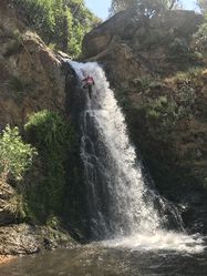
From the bridge enter Salmon Creek and proceed downstream on the canyon left side. There was (2011) a fair amount of brush and poison oak in this area, we generally found that the most clear path was staying in the middle of the watercourse. The first rappel (R1) is about 20' and can be walked around on the canyon right side if desired. The second rappel (R2) is about 50' and can be anchored from a stout tree directly behind the pour-over and puts you right in the middle of the fall.
R2-high flow
R2-low flow
The third rappel is about 30-40'
After this rappel the canyon narrows dramatically, you'll want to stay canyon right. In heavy flow you will want to bail out of the watercourse up to ridge on the canyon right side, traverse it, and anchor off of any of the numerous massive boulders up there to avoid the next rap. If you want to scout the last 2 rappels you would continue up to a bench on the canyon left side, which allows a view down into the canyon. If necessary you could rap off of one of several trees to avoid the last two waterfalls all together.
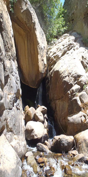
The fourth rappel (R4)(Rabbit Hole)is 10-15' into a short swim. This rappel requires careful consideration as you must enter a very narrow gap behind a large chock-stone.This rap should be monitored as rope entrapment usually occurs within the lower section.You can check by tugging the rope prior to rappelling.Also be mindful of foot entrapment as well. In heavy flow this would be deadly to enter. If the hole is blocked by flow, you can rappel over the top. You will have to install a long single anchor as to not stick your rope on the pull.
R4-low flow
R4-moderate-high
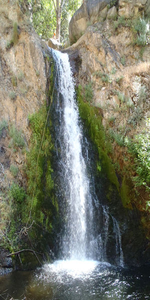
The fifth (R5)and final rappel is an approx. 90' off of a massive chock-stone in the middle of the watercourse. In 2011 there were two bolts on the west edge of this rock. If these bolts are not there your anchoring options are limited. This rappel can be tricky in very heavy flow. All of the water coming off the fall is funneled into a narrow hallway that you must swim through to exit. This hallway is about 6-8' wide and 15-20' long. Water is coming from 2 directions so the hydraulics in there can be difficult to ascertain and even more difficult to swim through. After the hallway there will be an additional swim of approx. 20-30' depending on sediment level. In the event that rap 5 is flowing too high - one person can rap down the big wall LDCL off a tree, and I believe two bolts have also been placed - to set up a guided rappel.
Escape route: From the top section where you would enter the Rabbit hole. There is a good used trail LDCL high up is a shelf you can climb up very easily. Be sure take the highest route. Follow this down back to the main egress trail.
R5-high flow
R5-low flow
Exit[edit]
After the last fall you will continue downstream, past an old sport climbing area, on the canyon left side. At about 35.900476 -118.457044 you will see an obvious use trail on canyon left. Follow it until you get to the ridge where you can bushwhack a short distance to a gravel road above you to the south. This gravel road is a fork of the road that you drove your 2nd shuttle vehicle on. Follow this road downhill and back to the highway side lot that you parked your 1st shuttle vehicle at. If you continue on the use trail, instead of accessing the gravel road, it will continue on to the small dam. Past the dam, through often-times thick brush and poison oak, you will need to cross salmon creek and find a use-trail back down (west)to the road and your shuttle vehicle.
Better shuttle drop off here 35.898064, -118.460855 Small dam (Also the best place to gauge flow) This will save you about 20 minutes, especially helpful when daytime temps are hot. The road you take off the Highway is here:35.893139, -118.464690 as you drive up you'll see an area used to turn your vehicle around 360 degrees so you can continue up the to trailhead call Rincon Trail here: 35.893274, -118.457212
Red tape[edit]
https://canyonaccident.org/lower-salmon-2022-04-23/
Beta sites[edit]
Trip reports and media[edit]
8/13/2022 Low flow conditions, air temperature around 100F. Trip time including hike in, out, and lunch break ~6 hrs. Swarms of gnats/mosquitos near the top of Salmon Creek bridge, but less bothersome at R2 and beyond. Bushwacking above R2 required, with poison oak along watercourse. New webbing added around a rock anchor on R2, but left existing webbing around downed tree trunk in place (less preferable pull and downed trees rotting throughout canyon). Some pools between R2 and R4 are swimmers, but water was refreshing. Lots of submerged branches, so watch for foot entrapment in the pools. Bolts on R5 are secure but anchor nuts needed to be tightened. Webbing is in good condition.
7/14/2019 (Ignore the thumbnail, the first half is Lower Salmon)
6/11/16 Current flow is moderate - We added three new anchors – R1. DCR off a stout tree into the watercourse (to be used under moderate conditions only). R2. DCL Optional off a small tree 40ft into the water about chest high – added purely for fun, you need to upclimb a ledge 20 ft. R4. DCL high off a tree – this is in case the rabbit hole is in high flow and is too dangerous 180 ft from the anchor.
5/13/17 Our trip was aborted due to extreme flows at the bridge - we observed class 2/3 rapids in the canyon.
7/15/17 Moderate high conditions, weather was hot around 107. Perfect conditions, cool water suitable for a 3/2 or spring suit. Replaced anchor on Rap 2 due to excessive wear. Replaced anchor on Rap 3 (Rabbit Hole) due to excessive wear. Footage of rabbit hole below.
6/13/19. Very high conditions. Rabbit hole submerged and last rap are flowing very high. Icy cold water.


