Santiago Hidden Falls Canyon
| Rating: | |||||||||||||||||||||||||||||||
|---|---|---|---|---|---|---|---|---|---|---|---|---|---|---|---|---|---|---|---|---|---|---|---|---|---|---|---|---|---|---|---|
| | Difficulty:3B IV PG (v4a2 IV) Raps:11, max ↨105ft
Red Tape:No permit required Shuttle:Optional 10min Vehicle:Passenger Rock type:Sandstone, Limestone, Granite, and Mix | ||||||||||||||||||||||||||||||
| Location: | |||||||||||||||||||||||||||||||
| Condition Reports: | 13 Jul 2025
"I did not do canyoneering here. I am only hiking up to the Luge flag. When I come back, I checked the cleveland NF closure, and I noticed that this ar |
||||||||||||||||||||||||||||||
| Best season: | During a rainy winter after a good rain
|
||||||||||||||||||||||||||||||
| Regions: | |||||||||||||||||||||||||||||||
Introduction[edit]
Orange County has few explored canyons (Salamander) that offer multiple significant rappels in water, so this canyon is a hidden gem. Visiting during a wet winter or spring after considerable rain fall will net you class B conditions. Flow will quickly fall off even with saturated ground; even after a week of exceptional heavy rainfall, flow is unlikely to reach class C. Small pools may stay wet into summer but even they are likely to dry up.
Approach[edit]
Car Shuttle (Full Route)[edit]
Park one car at the mountain bike parking at Cook Corner Restaurant. Drive to the Trucker Wildlife Sanctuary parking lot in Modjeska, CA. Hike up the Harding Truck Trail for 5.1 miles to a sharp bend to the left (0.3 miles past Laurel Springs). Head cross country through the burly bush (0.2 miles) to a small saddle roughly due South of the bend in the Harding Truck Trail. Once the saddle is reach, contour on your left, and you will soon reach the top cascade, which will most likely be dry.
Mountain bike (MTB) out and back (Sneak Route)[edit]
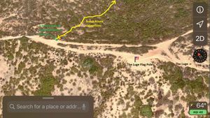
Park on Santiago Canyon road at crest of the saddle, bike up the steep Modjeska grade road then ride up the Santiago Truck Trail to the Luge Flag Pole knob. Lock your bike here, hike back down the knob to the trail split (about 150 feet) and head into the bushes where there is a little patch of moss. Follow the weakness in the brush with a few trimmed branches, into a small gully, back out following animal trails to a steep section with a fixed line. At the bottom veer left to avoid the thicket of poison oak. Once in Santiago Creek, head upstream 200 feet to a point on the North bank with a rotted and fallen tree and a short fixed line. Climb up here as it avoid the massive amounts of poison oak on the bank. Climb up the steep ridge directly in the center through 3 bush clusters to a more open ridge above. Continue up the ridge until you reach a boundary of thick brush at 2600 feet elevation. Contour around below the thick brush on animal trails, slowly working downhill, reaching a side gully at 2400 feet. Continue down the side gully with easy down climbs, but watch out for a massive poison oak bush blocking your path. Climb up left around this bush, and continue down. Just before reaching the main canyon, you will encounter a significant down-climb or rappel. If you traverse out of the gully left, you can get into the main canyon above one of its rappels, and possibly (have to verify as of JAN 2020) hike up canyon to a significant cascade waterfall which can been seen when contouring on this approach.
Potential Sneak Route (verified Jan 2020, see Mountain Bike out and back)[edit]
The bottom third of this canyon is the best part, it may possible to do a sneak route, but it's unverified how possible this is. The general idea would be to use the exit path to Santiago Creek, go upstream a short distance, and head directly up the ridge on the other side. The ridge is very steep for the first 100 feet, but eases after that. The brush is fairly light on the ridge because it's much drier south facing. After climbing up about 1000 vertical feet on the ridge, there is a significant gully that drains into this canyon above most of the rappels.
Descent[edit]
Full Route[edit]
The top cascade is easily down climbed when dry and a short distance below is a small headwall that can be avoided LDC. Below the headwall a short distance there is a spring in the creek bed. 0.8 miles downstream the middle cascade is reached, which is also easily down climbed. Much of this upper descent is clogged with small to medium sized dead wood, so progress downstream requires a lot of effort climbing over or breaking through branches. Roughly another 0.5 miles downstream the rappels begin. Most are short and reach 15 to 20 feet. It's possible to ghost many of the rappels. At this point travel in the canyon is WAY easier with much less brush and deadfall in the way. After a few short rappels the full route connects to the sneak route (next).
Sneak Route[edit]
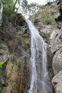
The sneak route connects at a short cascade rappel above a thigh deep pool with a wishbone dead tree spanning the canyon above the pool. After a few short down-climb in 300 feet you reach the 100 foot waterfall. At the 100 foot drop, we left 1" webbing around a massive tree (with large amounts of poison oak) LDC, 20 feet back from the drop. Currently, a minimum of 105 feet of rope is needed to reach the pool (filled in with gravel as of JAN 2020) at the bottom. From the bottom of the 100 foot is an entertaining down-climb with roots for hand hold. Be careful for rotten ones! Soon after is another short down-climb that can be easily rappelled off a small tree. 300 feet down canyon from the main 100 foot drop is a ~50 foot rappel with a unusually narrow U shaped notch directly at its top. This rappel is undercut with massive amounts of moss on the walls. Below this drop there are no more rappels to the main Santiago Creek, about 300 feet travel.
Notes[edit]
Both big drops have walls that are crumbly (PG rating), so be careful what you knock down the drop, especially by moving the rope around above you. Soon after these rappels, Santiago Creek is reached. Pools at the bottoms of drops are mostly knee to waist deep skirting the sides; some pools may be chest deep in the center; thus even in very low water flow it's possible to get soaking wet.
Exit[edit]
Non Shuttle[edit]
Hike down Santiago Creek for 2.5 miles, where you will reach a bridge across the creek. Climb up onto the bridge, head north (DCR) then left onto the road back about 1/4 mile to the Modjeska parking area.
Sneak and Car Shuttle[edit]
Hike down Santiago Creek for 0.4 miles. Soon after passing a huge steel cable in the creek and snagged high in the trees, you'll reach a bank on the left side that is grassy and not nearly so steep. There is a large birch tree leaning toward the creek here (DCL), with lots of poison oak at its base. Just beyond, follow the path around the poison oak next to a huge bush (at creek edge) to a steep slope with a fix line (JAN 2020). Scrambling up this steep slope for about 150 feet, the grade will decrease and there is an animal trail angling up and in the downstream direction, and this trail will reach a small drainage where the grade backs way off. From there head up the small drainage for 100 feet then out of it on the right side. Follow the weakness in the brush and you will soon reach the Santiago Truck Trail. Distance from Santiago Creek 300 feet below is only 1/8 mile. On your left is the knob with the flag pole at the top of "the Luge".
Car Shuttle at Cook's Corner[edit]
Turning left (south) there is a bare knob with a flag pole marking the top of "The Luge" (Morrow trail on the USGS topo). The Luge trail quickly descends to Live Oak Canyon road at the high point. To the West on Live Oak Canyon road, it's 0.8 miles back to Cooks Corner (Restaurant, motorcycle hangout, and mountain bike parking lot). Since this is no parking on Live Oak Canyon road and everything off this road is private, Cooks Corner is the best place to park the exit vehicle for the shuttle.
Red tape[edit]
As a result of the Airport Fire Closure this area is closed by the Forest Service from Oct 5th, 2024 to Oct 4th, 2025. See Forest order No. 02-24-29. Also closure map.
I believe this area is no longer closed to public access. The recent Cleveland NF closure map is here and it doesn't include this canyon. https://www.fs.usda.gov/sites/nfs/files/r05/cleveland/publication/alerts/Airport%20Fire%20Closure%20Area%20Map-%20FOREST%20ORDER%20NO.%2002-25-04.pdf
Beta sites[edit]
Trip reports and media[edit]
Background[edit]
Mountain bike (MTB) riders have known about the main waterfall for decades. Miners that worked a century ago in the mountains close to the main waterfall must have also seen it. First Canyoneering Descent: March 4th, 2017 by Willie Hunt and Christian Lupercio.

