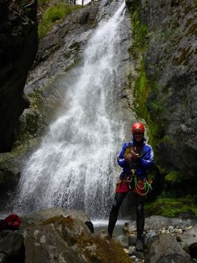
Sardine Creek (East Fork)
| Rating: | |||||||||||||||||||||||||||||||
|---|---|---|---|---|---|---|---|---|---|---|---|---|---|---|---|---|---|---|---|---|---|---|---|---|---|---|---|---|---|---|---|
| | Raps:6-10, max ↨90ft
Red Tape:Closed to entry Shuttle:Optional 30-60min Vehicle:High Clearance | ||||||||||||||||||||||||||||||
| Location: | |||||||||||||||||||||||||||||||
| Shuttle: | |||||||||||||||||||||||||||||||
| Condition Reports: | |||||||||||||||||||||||||||||||
| Best season: | April-July
|
||||||||||||||||||||||||||||||
| Regions: | |||||||||||||||||||||||||||||||
Introduction[edit]
Current Status: Closed. This creek was overrun by the Beachie/Santiam Fire in Sept 2020 and has been closed. Please check on local closures before planning a trip to this area. When the area eventually reopens, use extreme caution when descending the creek. Between landslides, fallen trees, and loose rocks, this area may be unstable and dangerous for years to come. The canyon may have changed dramatically. Do not rely on the beta below being accurate.
- Update 2025: According to Santiam State Forest the area is "closed until further notice."
This is a smaller eastern tributary of Sardine Creek. With a smaller catchment area, it's likely to be "open for business" earlier in the season. If flow on the main fork is too high, consider exiting below R6.
- The road below R6 is also a good place to check the flow before committing. At extreme flow conditions on the main fork (?) (5/29/17), water on the east fork crossing was shin deep.
Approach[edit]
Drive up Sardine Creek road and drop a vehicle at your exit. Pre-fire, the lower part of Sardine Creek Rd was a bit rough but could be driven carefully with a 2WD vehicle. High clearance or 4x4 may be recommended, however. There are a couple options:
- If you plan to descend only the east fork, park your car on the old road below R6.
- If you plan to continue down to the main fork, consult the main fork beta for options.
While hiking up to the top of the East Fork drop is possible, it's a lot easier with a shuttle. Again, there are two choices:
- The upper section of Sardine Creek Rd up and around Sardine Mountain is 4WD, and was in bad shape pre-fire.
- A friendlier 2WD option would be to backtrack all the way out to Hwy 22 and take French Creek Rd (near the Detroit Lake Bridge) up past Tumble Lake. A one-way shuttle will take about an hour. (This is almost the same shuttle as for Upper Sardine.)
Descent[edit]
From the parking area, drop directly into the drainage.
- Couple of 30ft waterfalls that can be rappelled or bypassed.
- R1: 30ft from a small tree middle of stream.
- R2: 90ft. This waterfall splits in two. Webbing is placed in the center section between the two waterfalls to avoid sharp ledges.
- R3: 70ft (DCL - tree)
- R4: 45ft (DCL - tree)
- R5: 65ft (DCL - tree)
- R6: 85ft (DCR - log). A courtesy anchor can be setup here.
Below R6, cross the old road. It's probably a good idea to exit here if the main fork of Sardine is running too high. If you keep going:
- R7: 35ft downclimb or rappel.
- R8: 65ft rappel. Avoid the log leaning against the falls by rappelling from an anchor on DCR.
Reach the confluence with the main fork of Sardine Creek. You will be entering between R13 and R14 as described on that page.
Exit[edit]
Most parties will either exit after R6, or will continue down to the main fork and exit via one of the options from the main fork.
Red tape[edit]
None.
Beta sites[edit]
Trip reports and media[edit]
Background[edit]
The East Fork of Sardine Creek was first descended on May 25, 2016 by Luca Chiarabini, Michelle Nilles, Ron Lebfrom, Tiffanie Lin, Erik Bernhoft, Andrea Lubreck, Jesse Houser, Dave Schroader, and Chad Carman.
