Saturio Canyoneering Canyoning Caving descenso de barrancos Barranquismo
Also known as: Barranco Saturio.
|
| Rating: |
Log in to rateLog in to rateLog in to rateLog in to rateLog in to rate 0.0 (0 ratings) |
|
|
| |
Raps:max ↨98ft | Overall: | 2h | |
|---|
| 35min | | | | 1.5h | ⟷0.5mi | ↑427ft | | 5min | | |
No Shuttle:None |
|---|
| Location: |
APPROXIMATE LOCATION! "°12'57.00"N" can not be assigned to a declared number type with value 43."°24'46.00"W" can not be assigned to a declared number type with value 2.
|
|---|
| |
|---|
| Condition Reports: |
(log in to submit report)
|
|---|
Weather: |
|
|---|
| Best season: |
Anytime | winter | | spring | | summer | | fall |
|---|
| Dec | Jan | Feb | | Mar | Apr | May | | Jun | Jul | Aug | | Sep | Oct | Nov |
|
| Regions: |
|
http://barranquismo.net/paginas/barrancos/barranco_saturio.htm,http://www.docuwiki.infobarrancos.es/doku.php?id=barrancos:gipuzkoa:saturio
43° 12' 57.00" N, 2° 24' 46.00" Westopo
GPS data automatically extracted from [], please visit their site for more detailed information.
Automatic GPS data extraction NOT allowed, please visit [] to download GPX.
Introduction
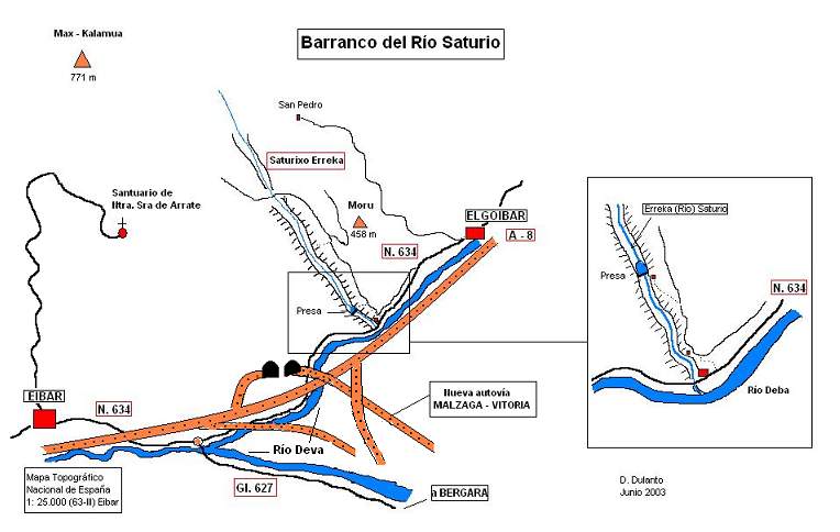
Acceso desde: Elgoibar (Guipúzcoa)
Altura de rápel mas largo: 30 m
Información del caudal: Caudal permanente. En invierno el río Saturio puede llevar mucha agua al tener una cuenca de recepción muy amplia
Material necesario: 2 de 40
Neopreno: En invierno necesario
Material de instalación: Existen colocados algunos anclajes. Durante el descenso se aprovecharon anclajes naturales. Aconsejable llevar material de instalación de repuesto
Epoca: Todo el año
Horario de aproximación: 35 minutos
Horario de descenso: 1 h 30
Horario de retorno: inmediato
Mapa: MTN de España 1/25.000 Eibar: 63-III
Zona o macizo: Monte Arrate (Guipúzcoa)
Cuenca: Río Deva (Guipúzcoa)
Altura en inicio: 200
Altura en final: 70
Longitud: 800 m
Desnivel: 130
Carácter: Abierto
Approach
Desde el cruce de la N-634 con la GI-627, en el paraje llamado Maltzaga/Malzaga, situado a 2 km del municipio de Eibar. Seguir la N-634 en dirección a Elgoibar. A 1 km de este punto el río Saturio desemboca por la orilla izquierda orográfica en el río Deva. Desde este punto se coge un pequeño camino junto a la casa que está junto al río y se sube luego por una buena pista que discurre junto al río. En un momento la pista cruza el barranco, y este punto es el comienzo del mismo.
Descent
Barranco excavado en roca volcánica (ofítas). De caracter abierto con grandes rampas y algunas verticales. Puede recoger mucha agua. Vegetación abundante en las orillas que no molesta en absoluto durante el descenso
Escapes: varios
Exit
Inmediato. El río termina en la N-634
Red tape
Beta sites
Trip reports and media
Background
9-Nov-03 DIEGO DULANTO (descendedor)
Primer descenso conocido. A. Requero, J. Lapresa, D. Dulanto en Junio del 2003.
 Barranquismo.net : Saturio