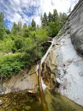
Second Hamongog
| Rating: | |||||||||||||||||||||||||||||||
|---|---|---|---|---|---|---|---|---|---|---|---|---|---|---|---|---|---|---|---|---|---|---|---|---|---|---|---|---|---|---|---|
| | Raps:4-11, max ↨150ft
Red Tape:No permit required Shuttle:Optional Vehicle:Passenger Rock type:Granite | ||||||||||||||||||||||||||||||
| Start: | |||||||||||||||||||||||||||||||
| Parking: | |||||||||||||||||||||||||||||||
| Condition Reports: | |||||||||||||||||||||||||||||||
| Best season: | May-Oct
|
||||||||||||||||||||||||||||||
| Regions: | |||||||||||||||||||||||||||||||
Introduction[edit]
Explored this canyon the same day we did Fort Creek (Upper), in what we thought was going to be the better of the two drainages. This route had been explored before as we found webbing on r2 (looked to be fairly recent). It is a worthwhile section to explore, but most likely not independent of anything else. If you're doing the Upper East Fork, it is recommended that you continue down Fort Creek (Three Falls) for a nice half day outing.
Approach[edit]
Park near schoolhouse springs and begin the steep hike up the service road (2.7mi, 2000' gain). You will go west at the First Hamongog and continue until the trail cut back to the east (prior to the 2nd Hamongog). Here you will break off and head downhill (west) into the drainage for the Upper East Fork of Fort Creek.
Descent[edit]
r1: 25' low angle rappel
r2: 150' to bottom (broke up into 100' and 50') > If broken up, get off rope LDC and look for slung boulder adjacent to watercourse (Ground level). > If your plans are to continue all the way down fort creek, just plan for your 150' since you will have that in the lower drainage.
After R2 there is a small hanging garden on your right. This seep continues as you make your way down to R3.
r3: 50' (set back tree)
r4: 100' from a tree RDC > Another option is to downclimb left for 20' to a slung boulder. 75' to the ground.
Soon you will come to the confluence with Fort Creek (Upper), and you can continue down canyon until you reach the Fort Creek gardens and the technical section for the lower canyon (145' max).
Exit[edit]
Exit at the bridge and hike the bike trail back to your shuttle car.
