Shadowfoot Hollows
| Rating: | |||||||||||||||||||||||||||||||
|---|---|---|---|---|---|---|---|---|---|---|---|---|---|---|---|---|---|---|---|---|---|---|---|---|---|---|---|---|---|---|---|
| | Difficulty:2A III (v1a1 III) Raps:0
Red Tape: Shuttle:None Vehicle:4WD Rock type:conglomerate | ||||||||||||||||||||||||||||||
| Location: | |||||||||||||||||||||||||||||||
| Condition Reports: | 30 Dec 2017
"4.5 hours car to car. Hiked out through the hills of the other drainages which is a pain - would be better to hike down Teakettle Wash, then hike up |
||||||||||||||||||||||||||||||
| Best season: | BEST in winter, spring, fall
|
||||||||||||||||||||||||||||||
| Regions: | |||||||||||||||||||||||||||||||
Introduction[edit]
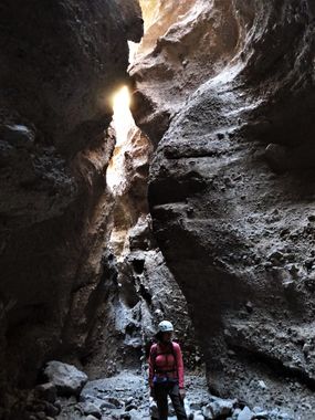
Two surprising and interesting nontechnical slot canyons by Lake Mead at the foot of the Black Mountains near the Arizona/Nevada border. Though the hike to get to and from the canyons can be a little tedious as you traverse the many slopes of the adjacent drainages along the way, the canyons are beautiful and easy.
From US93 in Arizona, turn north on Temple Bar road which is north of mile marker 20 and well signed. Take this paved road for 13.2 miles, then stay straight to follow signage for Bonelli Bay onto a nicely graded dirt road. At 4.1 miles turn left onto Cohenour Loop Rd (there is a small sign) which becomes more loose gravel and a bit bumpier. There are no great parking areas, but look for a place to pull out after around 2 miles, we parked at a small pullout on the left just big enough for one car at 2.2 miles.
Approach[edit]
We made a straight shot to the north on the approach which takes you through the many upper hills of the other drainages, but it may be easier to follow the main drainage in the area (Teakettle Wash) and then explore from there. Either way the one important thing to know is that the upper part of the southern fork of Shadowfoot Hollows can only be accessed on the south side of the canyon, the north side is a vertical wall, so you can't go up the north fork, then hike straight down to the south fork to descend back to the wash. Were I to do this hike again I would hike north through Teakettle Wash, then hike west up to the upper part of the south fork through one of the more minor drainges just south of it. The north fork is shorter and more straight forward and can be explored out and back in less than an hour.
Descent[edit]
There are two distinct slots for this hike: north and south forks. The north is shorter and less deep, but is a winding narrow slot; the south fork is longer, deeper and more scenic. Both forks have a moderately difficult 10 foot downclimb near the top, some may wish for a rope to assist with descending these, most will not - bring a short rope if you have any concerns about it - the southern fork has only a few other small, easy downclimbs . If approaching the southern fork from its head, there is only one way in: on the southern side you can scramble into the canyon, then bypass a short vertical obstacle on the right. The northern fork can be approached from either above or below. The most straight forward way to complete the trip is to approach the southern fork to its head on the approach, descend, then hike up to and explore the north fork out and back.
Exit[edit]
Hike back to the south through Teakettle Wash (not named on topo maps - it's the main drainage all the canyons is the area are tributary to). After roughly 2.5 miles you'll come to the head of the wash and have to navigate around and through some hills to get back to the road, but nothing is terribly difficult in the area - a GPS is a smart thing to have for navigation here.
Red tape[edit]
Shadowfoot Hollows is within Lake Mead National Recreation Area which requires entry fees. There is an entry station on Temple Bar Road, which seems to be closed in the off season. Daily single vehicle fees are currently 20$ per car, an interagency annual pass gets you in as well.
