SkyFall
| Rating: | |||||||||||||||||||||||||||||||
|---|---|---|---|---|---|---|---|---|---|---|---|---|---|---|---|---|---|---|---|---|---|---|---|---|---|---|---|---|---|---|---|
| | Difficulty:3A II (v3a1 II) Raps:3, max ↨130ft
Red Tape:No permit required Shuttle:Optional 2mi Vehicle:Passenger Rock type:Compressed Ash | ||||||||||||||||||||||||||||||
| Start: | |||||||||||||||||||||||||||||||
| Parking: | |||||||||||||||||||||||||||||||
| Shuttle: | |||||||||||||||||||||||||||||||
| Condition Reports: | |||||||||||||||||||||||||||||||
| Best season: | Spring and Fall
|
||||||||||||||||||||||||||||||
| Regions: | |||||||||||||||||||||||||||||||
Introduction[edit]
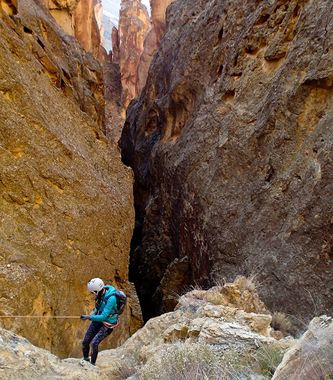
An excellent canyon given it's ease of access and beautiful approach up Juniper Gulch. It was named after a rolling rock that nearly hit a guy named Skye. He avoided it by pushing off of the wall while on rappel. There were many loose rocks on the first descent. Subsequent descents have been cleaner.
Approach[edit]
Hike up Juniper Gulch and head Southwest to the drop in point.
Descent[edit]
Original route: From the Southern drop in shown on the map, the beginning of the canyon is fairly wide open with a lot of loose rock. Be careful not to roll rocks onto your companions. Before reaching the first rappel, you will find a number of obstacles to go through, including arches and challenging downclimbs. The first rappel is 130ft from a bolt and webbing around a small arch left down canyon. The first rappel is the main attraction of the canyon and is quite beautiful. The next two rappels are in the 40 to 50ft range from webbing on boulders. The first of these two is at the end of a fairly fresh looking rock fall boulder field. The most desirable drop is off of a boulder down canyon right out in a grassy area away from the boulder field. The last rappel is off of a boulder pinched in the canyon walls.
Middle new and improved entrance route! From the Northwestern top drop in point, the map shows West and East canyons. The East of the two is what I am calling the middle canyon. It is the most fun of all entrances that we have explored so far! It begins with the downclimb / rappel chute entrance for both the East and West canyons. After the downclimb / rappel chute, follow the track to the waypoint labelled "Top of Middle Canyon." From there, you will drop fairly quickly and soon come to a big cliff. This cliff involves two drops. The first is 120 feet from around a big wedged boulder down to a flat ledge that is about 20 feet in each direction. At this ledge, you will see a crack in the wall down canyon right. We slung a giant bounder pinch point here and rappelled from inside the cave like crack. This rappel is 220 feet and is very impressive with amazing rock formations all the way down. This rappel drops you out very close to the beginning of the 140 foot rappel into the slot section where all forks meet up.
Western new and improved entrance route! From the Northwest entrance drop in, you will find a gully that contains some challenging downclimbs. We rigged a 30ft rappel towards the end of this gully, but it can be downclimbed after closer inspection. From here, there are at least three routes down into the main canyon. After some fun downclimbs, we scrambled around down canyon left a little and came to a very big drop! We decided to bolt it as there were no other good options. I placed a waypoint labeled "Bolts" as close I could get my phone to track to where they are. This drop is 250 feet! The last 100+ feet is free hanging, so be prepared to hang your pack if you have much weight in it. We used webbing to equalize the bolts and a fiddle stick to make sure we didn't have any pull issues. I think that a standard clove hitch block would still go over the edge just fine after seeing it on the way down. Immediately after the big, amazing drop, you come to the big slot that is the first rappel of the standard route, but you come at it from the other side and there is no way to get to the original anchors. We slung webbing around a boulder. From the webbing, this route in requires 140 feet of rope rather than the 130 feet from the other side. Both Southern entrance routes are FAR more adventurous and fun than the boulder alley that you have to go down for the original route. The West route has more fun downclimbs with one really impressive rappel, whereas the middle route has two big drops with awesome features along the way. They are both worthy of exploring.
Exit[edit]
You may want to take two vehicles to shuttle from Juniper Gulch to the bottom of the canyon at 43.315556, -117.296302. The other option is to hike up the road back to your starting vehicle (+2mi, 450ft elevation gain).
Red tape[edit]
Beta sites[edit]
Trip reports and media[edit]
1st descent pictures: https://www.facebook.com/media/set/?set=a.10152892932593738&type=3
A few more pics: https://www.facebook.com/media/set/?set=a.10158973482558738&type=3
"Middle" entrance pictures (East Canyon from the Northwestern drop in point): https://www.facebook.com/mcweyen/posts/pfbid02YW6jEYj5xaHwWDGNTmM95VSGjYnQAXVf4YG7gAMHwYA7nkajm8u2WX55Coha5bRVl
A video of the two big "middle entrance" canyon rappels: https://www.youtube.com/watch?v=1wPVxYHB-9A
