Snag Creek
| Rating: | |||||||||||||||||||||||||||||||
|---|---|---|---|---|---|---|---|---|---|---|---|---|---|---|---|---|---|---|---|---|---|---|---|---|---|---|---|---|---|---|---|
| | Raps:2-3, max ↨130ft
Red Tape:No permit required Shuttle:None Vehicle:High Clearance | ||||||||||||||||||||||||||||||
| Start: | |||||||||||||||||||||||||||||||
| Parking: | |||||||||||||||||||||||||||||||
| Condition Reports: | 15 May 2021
"No signs of anchors or other presence were found, so this was probably a first descent. Pretty thrashy in sections on the way in and out, but the cre |
||||||||||||||||||||||||||||||
| Best season: | Mar-May
|
||||||||||||||||||||||||||||||
| Regions: | |||||||||||||||||||||||||||||||
Introduction[edit]
Snag Creek is a relatively minor tributary of the nearby Rock Creek. While the waterfalls are nice, but Snag loses some points for a strenuous entry and exit. The pay-to-play ratio is a bit high on this one, so, arguably, it's probably best for for Portland canyon-obsessives who feel the need to rappel every drainage in the Rock Creek watershed. There are certainly better canyons in the area. Come early in the season for better water and easier travel. The local forest is a jungle; expect to get your bushwhack on.
- Checkpoint: Before driving up to the parking area, take a left at the road junction at about 1600ft and travel 0.1mi to a bridge across Snag Creek.
Approach[edit]
Google Maps lies, but the road abruptly ends at a junction / turnaround at about 2000ft elevation. Park here, and continue on foot past the giant berms and up the decommissioned road for about 1mi. The going is a little thrashy at first, but the road soon opens up again and becomes grassy / relatively easy to travel. Follow the old road up to around 2400' elevation where it abruptly ends and plunge into the forest. Thrash on up the ridgecrest wherever is easiest. Here and there are remnants of an old human-made path to make the going a little easier, but it comes and goes. Eventually break out into a lovely grassy cliff-top meadow with wildflowers in season. Continue on up and north to almost 3000ft before breaking off the ridge and descending into the Snag Creek drainage on a descending traverse to the north. Your goal is to drop into the creek at about 45.7855, -122.0326, just above the first waterfall. The vine maple is thick dropping off the ridge, so it's a bit slow-going. Once in the creek, suit up, and head downstream.
Descent[edit]
- R1: 25ft from tree DCL. (Or downclimb?)
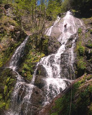
Head downstream through a nice area of bedrock. It narrows up in a couple spots. Downclimb a few cascades to the top of Snag Creek Falls (R2 + R3).
- R2: 100ft from small tree DCR to a large platform mid-falls.
- R3: 130ft from tree DCL that puts you right in the watercourse. Watch for a hanging pool mid-way down.
Head downstream through some more nice bedrock.
Exit[edit]
Sadly, the bedrock section ends all too soon. At this point, you're better off de-wetsuiting and hiking out. Initially it's best to head downstream about 0.2mi on the west side (DCR). Cross the creek, then thrash 0.25mi to a clearcut. Pick up a faint track right of the tree island and drop down to a decent dirt road that leads back to the parking area.
Red tape[edit]
None.
Beta sites[edit]
Trip reports and media[edit]
Background[edit]
First descent was made by Kevin Clark, Wade Hewitt and Ashley Driscoll in May 2021.

