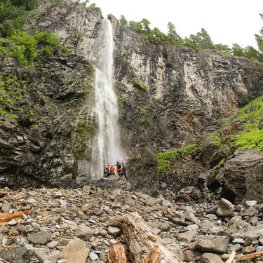
Snagtooth Creek
| Rating: | |||||||||||||||||||||||||||||||
|---|---|---|---|---|---|---|---|---|---|---|---|---|---|---|---|---|---|---|---|---|---|---|---|---|---|---|---|---|---|---|---|
| | Raps:1, max ↨320ft
Red Tape:No permit required Shuttle:None Vehicle:Passenger | ||||||||||||||||||||||||||||||
| Location: | |||||||||||||||||||||||||||||||
| Condition Reports: | 4 Jul 2018
"Had been wanting to check out this falls for a while. Disappointed we could not rappel directly in the water course with a 300 rope. A very beautiful |
||||||||||||||||||||||||||||||
| Best season: | Summer
|
||||||||||||||||||||||||||||||
| Regions: | |||||||||||||||||||||||||||||||
Introduction[edit]
Snagtooth Creek features one of the highest plunging waterfalls in Washington south of Mt. Rainier. The creek will take you to the rim of a large amphitheater with amazing views. The falls is notable for its size and also being off the beaten path with relatively few visitors.
Approach[edit]
As of 2018, a significant rockfall has blocked forest road 9341 at around 46.2300, -121.8285. There is room to park here, and it is easy to hike through the rockfall and continue walking along the road on the other side. Around 1.2 miles from the start, the road turns left and heads directly north. Continue up the road and cut into the timber about 1.5 miles in. Cutting in sooner may be possible to start closer to the falls.
Note: A GPS track was not taken on the first descent. The current map route is a rough estimation of the route taken.
Update 2023 - reportedly the major rockslide on FR 9341 has been repaired so a fire crew could get up to Snagtooth Creek.
Descent[edit]
Follow the creek down until you reach Snagtooth falls. There are a couple of small pools to navigate prior to the falls, including a slide, but nothing significant.
The falls itself has not yet had a documented descent in the watercourse. While the listed height of the falls from top to bottom is 311' on Waterfalls Northwest, an initial measurement with a 300' rope came up more than 10' short, though it was difficult to tell how short from the top. Natural anchor options here are limited.
The first descent team rappelled from a tree DCL at the rim of the cliffband, approximately 260'. This was a free hanging rappel. There are many potential tree anchors along the cliff here but access can be difficult. Use caution and carefully assess any tree anchor you choose to rappel from. Be wary of loose rock and debris.
Exit[edit]
From the base of the waterfall, follow the creek down until a route up the hillside down canyon right looks accessible. On the first descent trip in 2018, we took quite a steep route up the hillside and the climb out was difficult with significant loose dirt and rock. It is unknown if a route up the hillside is any easier further down canyon.
The terrain flattens out significantly at the top of the hillside and the hike back to the road is fairly easy with minimal bushwhacking.
Another possible exit involves continuing down the creek until it meets the Quartz Creek trail, then hiking out to Forest Road 90. The exit this way would be much longer at about 4.2 miles and has not been documented by canyoneers. This exit would also require a shuttle.
Red tape[edit]
Beta sites[edit]
https://www.waterfallsnorthwest.com/waterfall/Snagtooth-Falls-5294
Trip reports and media[edit]
Background[edit]
First documented canyon descent on July 4th, 2018 by Haruka-James Clay Lipscomb, Kris Torgles, Jana Dong Lovelady, and Jake Huddleston.
