Snyder Creek (Upper) Canyoneering Canyoning Caving
Also known as: Snyder Creek.
|
| Rating: |
Log in to rateLog in to rateLog in to rateLog in to rateLog in to rate 2.0 (1 rating) |
|
|
| |
Raps:3, max ↨80ft | Overall: | 3.5-6h | ⟷5mi |
|---|
| 30-45min | | ↓400ft | | 2-3h | ⟷0.8mi | ↑400ft | | 1-2h | | ↑800ft |
No Shuttle:None Rock type:Basalt |
|---|
| Location: |
|
|---|
| |
|---|
| Condition Reports: |
11 Jan 2026
"2 main drops are fun. Anything else is a chore.
(log in to submit report)
|
|---|
Weather: |
|
|---|
| Best season: |
Feb-June | winter | | spring | | summer | | fall |
|---|
| Dec | Jan | Feb | | Mar | Apr | May | | Jun | Jul | Aug | | Sep | Oct | Nov |
|
| Regions: |
|
45.8453, -121.2179topo
GPS data automatically extracted from [], please visit their site for more detailed information.
Automatic GPS data extraction NOT allowed, please visit [] to download GPX.
(log in to submit reference picture)
| Welcome! Canyons in the Pacific Northwest can be different from those you might be used to. Be ready for unlinked bolts, retrievable traverse lines, and challenging aquatic environments. For more on local practices, and the best way to get started in the region, check out the WCC Safety page.
- Unlinked Bolts - groups should be comfortable rigging unlinked bolts, either temporarily linking them for all but the last person, or using a passive redundancy method. Most importantly, if you find two bolts side by side that are unlinked, do not add webbing to them. Linking bolts designed to be unlinked will likely cause damage during seasonal floods.
- Traverse Lines - many canyons are rigged to allow traverse line access to an exposed anchor station. This should be done using self-belay or team belay techniques. Do not leave fixed lines in the canyons.
- Challenging Environments - the highly aquatic nature of PNW canyons can surprise many. Cold temperatures, slippery rocks, loud waterfalls, and strong currents all lead to unexpected problems. Do not underestimate the need for strong team work and technical proficiency. Belays are frequently not possible. Unattended gear will sink or float away. Sliding and jumping is the cause of most major injuries, so it's critical to effectively communicating water depth & submerged hazards.
|
Introduction
Snyder is a major creek that played a role in the town of Klickitat’s logging operations. The creek portion of this trip is mostly on DNR/ SDS land and there aren’t any restrictions for when this creek is runnable.
Title makes you think there is a lower section. There isn’t one.
Approach
Drive up on Klickitat- Appleton Road to the intersection of Fisher Hill. Take a right and drive to you reach Brewer Rd. There is a nice camping spot on the left .5 up. You can also camp where the road crosses Simmons Creek. Walk the old logging road along Simmons Creek until just before the confluence. R 1, which we did not run awaits. Looks to be a two tiered 40 foot drop. We were interested in the bigger stuff.
Went back, upper stuff is brushy af. Not worth the squeeze.
Descent
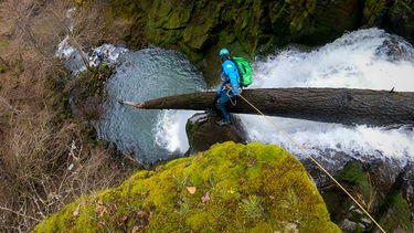
R1- 40ish foot two tiered drop into a small gorge.
R2- 40” from a tree DCL
R3- 80” from a bolt DCL, if anyone wants this adventure a bolt station DCR could be a much better and safer route as DCL puts you either in the brunt of the flow or hanging from a very sharp rock.
Exit
Although we did not take this way out, exit DCL when able and walk back up to the old road you came in on. Any other way quickly makes this canyon not worth the effort.
Red tape
Running the entire canyon would be a chore. It would also put you in private property a couple of times. Just avoid it. But no different than Prindle.
Beta sites
Trip reports and media
Background
This was scouted by myself and Michael Peterson in mid January 2021. It looked better via drone 😂
_Banner.jpg)