Soda Creek Canyoneering Canyoning Caving
The exploration of this location has not yet been documented
All information is unverified estimation |
|---|
|
| Rating: |
Log in to rateLog in to rateLog in to rateLog in to rateLog in to rate 0.0 (0 ratings) |
|
|
| |
Raps: | Overall: | | ⟷4.3mi |
|---|
| ⟷2.7mi | ↑1400ft | | ⟷0.9mi | | | ⟷0.7mi | |
No Shuttle:Required 5min |
|---|
| Start: |
|
|---|
| Parking: | |
|---|
| Shuttle: | |
|---|
| |
|---|
| Condition Reports: |
(log in to submit report)
|
|---|
Weather: |
|
|---|
| Best season: |
May-Jul | winter | | spring | | summer | | fall |
|---|
| Dec | Jan | Feb | | Mar | Apr | May | | Jun | Jul | Aug | | Sep | Oct | Nov |
|
| Regions: |
|
https://www.waterfallsnorthwest.com/waterfall/Lower-Soda-Falls-4396
44.4188, -122.470744.4034, -122.439844.3991, -122.4808https://ropewiki.com/images/7/7f/Soda_Creek.kmltopo
GPS data automatically extracted from [], please visit their site for more detailed information.
Automatic GPS data extraction NOT allowed, please visit [] to download GPX.
Reference photos
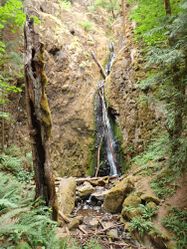
1 Aug 2020:
Low. Not as fun, but should be safe even for beginners (class B/C = a3). Did not run.
These reference pictures are used in the
Waterflow analysis to predict current conditions. More reference pictures will produce a more reliable prediction.
(log in to submit reference picture) | Welcome! Canyons in the Pacific Northwest can be different from those you might be used to. Be ready for unlinked bolts, retrievable traverse lines, and challenging aquatic environments. For more on local practices, and the best way to get started in the region, check out the WCC Safety page.
- Unlinked Bolts - groups should be comfortable rigging unlinked bolts, either temporarily linking them for all but the last person, or using a passive redundancy method. Most importantly, if you find two bolts side by side that are unlinked, do not add webbing to them. Linking bolts designed to be unlinked will likely cause damage during seasonal floods.
- Traverse Lines - many canyons are rigged to allow traverse line access to an exposed anchor station. This should be done using self-belay or team belay techniques. Do not leave fixed lines in the canyons.
- Challenging Environments - the highly aquatic nature of PNW canyons can surprise many. Cold temperatures, slippery rocks, loud waterfalls, and strong currents all lead to unexpected problems. Do not underestimate the need for strong team work and technical proficiency. Belays are frequently not possible. Unattended gear will sink or float away. Sliding and jumping is the cause of most major injuries, so it's critical to effectively communicating water depth & submerged hazards.
|
Introduction
Oregon prospect. At least two major drops marked on USGS maps: Upper & Lower Soda Falls. This creek doesn't have much of a watershed and is likely best visited in late spring. Not to be confused with the "Soda Fork Creek" located 10mi further east.
Watershed: ~1.0mi^2.
Approach
Descent
- Lower Soda Falls: 130ft multi-tier falls descending in multiple tiers through a tight narrows.
Exit
From Lower Soda Falls: a 0.5mi trail leads back to the parking area at Cascadia State Park.
Red tape
Beta sites
Trip reports and media
Background
