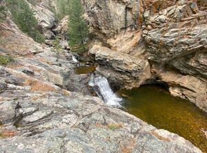
South Saint Vrain Narrows
| Rating: | |||||||||||||||||||||||||||||||
|---|---|---|---|---|---|---|---|---|---|---|---|---|---|---|---|---|---|---|---|---|---|---|---|---|---|---|---|---|---|---|---|
| | Raps:1-3, max ↨60ft
Red Tape:No permit required Shuttle:Optional 4.2 mi Vehicle:Passenger | ||||||||||||||||||||||||||||||
| Start: | |||||||||||||||||||||||||||||||
| Parking: | |||||||||||||||||||||||||||||||
| Shuttle: | |||||||||||||||||||||||||||||||
| Condition Reports: | 28 Jun 2025
"The tail end of snowmelt produced exciting swiftwater challenges in these brief narrows. Descending this canyon without swiftwater exp |
||||||||||||||||||||||||||||||
| Best season: | Aug-Oct
|
||||||||||||||||||||||||||||||
| Regions: | |||||||||||||||||||||||||||||||
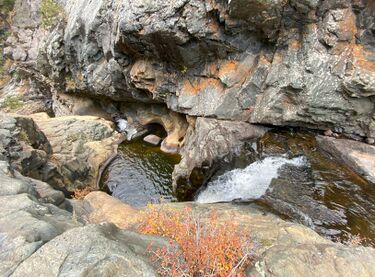
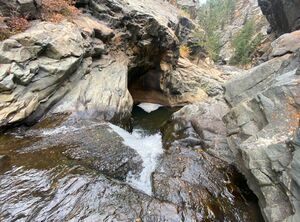
Introduction[edit]
South Saint Vrain Creek briefly carves through a beautiful section of narrows that is quite unique for canyoning in the Front Range, featuring a handful of short drops, a couple deep pools and at least one notable swim. As enjoyable as this short section of canyon is, it is far too short and over too quickly. This canyon is highly flow dependent. The creek runs very strong during run-off, and would make the canyon very dangerous, if not impossible to descend safely. However, by late summer or early fall, flows usually drop off enough to make a descent very reasonable. The narrows can be approached either by using a shuttle vehicle, or by parking at the exit point listed in this write-up, and performing a round-trip. However, the round-trip adds a little over a mile of bushwhacking and about 700 feet of additional elevation gain. Considering how short the technical portion of this canyon is, the round trip is hard to recommend. The details in this write-up describe the shuttle route, which is still difficult to recommend considering the high pay to play ratio.
Water Checkpoints The described approaches do not allow for observation of the creek flow until you've already invested significant efforts reaching the creek, but there are a couple good spots to check water flow before beginning the creek.
Continue up James Canyon drive to the Ceran Saint Vrain trailhead. At the trailhead is a bridge which crosses South Saint Vrain Creek. The waterflow at this crossing provides a good representation of waterflow in the canyon, though at a wider portion of the creek. Consider all of this flow restricted to about a 3-4 foot wide corridor for an approximation of flow levels at the tightest portion of the narrows.
One can also observe the flow levels at the confluence of the south and middle forks of the saint vrain creeks off of Highway 7 well below the narrows, though this option is generally out of the way.
Approach[edit]
SHUTTLE ROUTE
If performing a shuttle route, park your exit vehicle at the end of County Highway 87. The road ends at the entrance of the Cal-Wood Educational center, and where the now-closed Cannon mountain jeep road begins. The exit route will come out from the closed 4x4 road, which is gated, but has a small opening to allow hikers to pass. This area tends to be sensitive with private land-owners, and there is some extra sensitivity due to being an educational area where school children are present. As such, it is likely wise to tread lightly, and park as discreetly as possible. There is plenty of room to park a handful of vehicles, but be sure not to block gates or the entry to the educational facility.
Return down Road 87 to James Canyon drive with the entry vehicle, and continue uphill (right) on James Canyon Drive through 3 increasingly tight left turns for about 1.9 miles. The best spot to park your entry vehicle is in the shoulder of the 3rd tight turn, which has plenty of room for several vehicles. From here, begin hiking north up the gulch where a small trail will quickly appear. Continue up this trail until it meets an old Jeep road which makes a switchback or two, and then continues North for less that a quarter mile before hitting a tee intersection. At the tee, continue north departing from the road system, on fairly flat terrain. Travel is generally easy, as the bush is not too thick in this area. As the slope begins to descend on the left (west), begin descending Northwest towards the creek. Remain on the East side of a gulch that descends this slope in order to minimize bushwhacking. As you approach the river, a rock outcropping will be visible. To avoid steep dropoffs leading to the creek, go to the right (north) of the rock outcropping where the brush becomes quite thick, but easy to descend to the creek. Once at the creek, continue downstream for about 1/4 mile to reach the first drop. During low water, it is generally easier to travel in the creekbed instead of bushwhacking on the edges. If crossing the creek seems difficult, or if the water level is too high such that travel on the edges of the creekbed is not possible, the water level may be too high for descent. The canyon will get more narrow until the creek goes through a couple small bypassable waterfalls while turning to the right before carving down into the first technical drop. Cross the creek to the DCL shore where a large slab provides a good place to suit up. Below the slab is a small shelf area with about three trees, one of which provides a possible anchor for the first notable drop.
ROUND TRIP ROUTE (Not Recommended)
This route will add over a mile of bushwhacking and around 700 foot of elevation gain to the overall route. Park at the exit vehicle location described above to minimize the exit hike carrying wet gear. Hike through the opening in the gate, and continue down the cannon mountain road. While this road appears to be public access itself, This first portion of the road crosses the Cal-Wood property, which is heavily signed as such. Stay on the road. The road will drop down and eventually begin to gain elevation as it trends westward, and begins a series of switchbacks up the mountain. Follow the switchbacks, or take established bypasses to cut the switchbacks. Eventually, this road will come upon a mine that is fenced off. Turn left and continue. There may be old faded "no trespassing" signs here, but current maps show this region as National Forest. Depart the road, and continue dues west. There is a plot of land that is owned by Boulder county, and fenced off with barbed wire, and marked with faded no trespassing signs in places. Stay north of the fenceline as traversing west, staying on national forest. The fence line will quickly end as you travel away from the old jeep roads. Mapping software with property boundaries is helpful here to avoid unintentional trespassing. Continue traversing due west through heavy brush for about half of a mile, before turning and heading uphill once the boulder county property line is cleared. Once the terrain levels off, continue heading west another 0.4 miles or so. Descend down to the creek, as is described in the Shuttle route description above.
Other Options The canyon can also be accessed from the Ceran Saint Vrain Trailhead. This approach involves about 2 miles of easy hiking on well established trails, followed by about a mile of bushwhacking and creekwalking to reach the start of the narrows. A shuttle would likely be necessary, as returning to the ceran saint vrain trailhead would make for a very difficult and long exit.
The Miller Rock OHV roads may also provide a way to access the canyon, though a very capable high clearance vehicle would be required.
Descent[edit]
The first notable drop is identifiable where the water drops into a large cauldron with slightly overhung walls on both the DCL and DCR sides. In low flow conditions, no hydraulics should be present anywhere in the canyon, though during high flow, they certainly might be possible. Analyze the flow here before continuing.
NOTE: Rope lengths are approximate, and likely a little generous. A 200' rope was used for this write-up, but the full length was never used. A 120' should be sufficient.
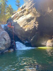
Rappel 1 (Approx 30 feet)
A tree DCL provides a good anchor for this rappel. Rappel about 30 feet or so down to the pool below. The rappel line from this tree will drop the rappeler directly into a channel with the fullt flow of the waterfall, before the rappeler moves over the edge and drops into the pool. The pool below is about chest deep in most places, but might be a little deeper right where the rappel ends. Set the rope length to prevent issues coming off of the rope.
Rappel 2 (Approx 30-40 feet, longer rope helpful for pull)
The next anchor is on a shelf DCL that is perched above this first pool. Scramble up the wall DCL to access the tree. The creek now exits from the pool DCR, and drops into several small potholes before exiting into a large pool below. These drops might be down climbable in low water conditions. Those who choose to rappel will rappel about 30 feet into the final pothole before it pours over into the large pool below. Rappel into the pool, or disconnect at this final rappel, and jump about 5-6 feet into the pool below. Be sure to check the depth. This pool is a swimmer, but during low water conditions, the water can be a little murky, and it is difficult to determine the depth. Swim about 30-40 feet across the pool to a rocky beach. If your rope is long enough, pull from this beach. Continue a few hundred feet down canyon before reaching the final notable drop.
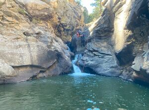
Rappel 3 (Approx 60 feet, 20 foot drop with anchor set back about 40 feet from the edge)
The final drop is a low angle waterfall about 20 feet wide, and 15-20 feet tall. During low water conditions, this drop could likely be downclimbed DCR, or possibly even carefully jumped. Be sure to check the depth. For those who choose to rappel the drop, trees both DCR or DCL can be a suitable anchor, however, all trees are about 30-40 feet back from the edge. The rappel will drop into a pool that is a brief swimmer, and exits onto another rock beach on the downcanyon side. A longer rope can be helpful here to allow for an easy pull from the downcanyon beach.
After this final drop, ropes and harnesses will no longer be needed. Continue down a few more small downclimbs and waist deep pools as the canyon opens up.
Exit[edit]
After the final drop, continue creekwalking down the creek for about half of a mile. A gulch DCR provides the exit. A good marker for the gulch is a significant group of fallen trees that span the entire creek and much of the DCL creek shore. The gulch will come into view just after this blockage of trees that must be crossed. A small rocky beach DCR can provide a decent spot to remove wetsuits, if you have not done so already.
Work up the climber's left side of the gulch. Initially, there is no clear trail present, but quickly, a small trail will appear that stays well above the watercourse of the gulch. Continue up this trail for about a quarter mile. Keep an eye out to the right downslope where the end of an old jeep road eventually comes into view. Once this road is identified, traverse until you hit the road, and follow this old jeep road up the hill. The road will continue for another 0.4 miles climbing steeply before cresting at the top of a hill, and beginning a descent downwards. Follow the switchbacking road down hill, or use established cut throughs until the road levels, and hits a fork. Continue uphill to the right at the fork, where the road climbs before reaching a hairpin turning right, and continuing to climb to your exit vehicle. Take note that this road cuts through a section of land owned by the educational facility. Remain on the road for this portion of the exit.
Alternate Exit Once could also continue down creek until the South fork of the Saint Vrain meets the middle fork at highway 7. This exit would involve about 3 miles of creekwalking, and does briefly cross private land just before reaching highway 7.
Red tape[edit]
The described route stays on public lands for its entirety. However, there is an abundance of private land in the area that can be easy to wander on to. Use discretion during the approach and exit. GPS software with private land boundaries, such as Gaia, can be very helpful.
The Exit parking and a section of the exit road are public, but border the cal-wood educational center's property on both sides. There are many posted signs that warn about this. Be respectful while traveling near the educational areas.
