South Santiam River
| Rating: | |||||||||||||||||||||||||||||||
|---|---|---|---|---|---|---|---|---|---|---|---|---|---|---|---|---|---|---|---|---|---|---|---|---|---|---|---|---|---|---|---|
| | Raps:0, max ↨0ft
Red Tape:No permit required Shuttle:Optional 5min Vehicle:Passenger | ||||||||||||||||||||||||||||||
| Location: | |||||||||||||||||||||||||||||||
| Condition Reports: | 18 Aug 2024
"We pack rafted this at about 95 CFS. Much better as a float than a canyoneering route. Id recommend pack rafts if the flow is close to 100 CFS or hig |
||||||||||||||||||||||||||||||
| Best season: | Jul-Sept
|
||||||||||||||||||||||||||||||
| Regions: | |||||||||||||||||||||||||||||||
Introduction[edit]
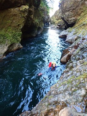
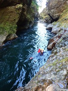
Non-technical, but extraordinarily beautiful river gorge. Great way to cool off on a hot summer's day - or possibly a rest day between technical outings. Consider wearing a PFD or have your flotation dialed as there are some very long stretches of swimming. There is lots of jump potential along the way. It's something of a non-technical water park. Helmets are a good idea for safety as the rock surfaces can be extremely slippery. Slipping and banging your head is no fun.
Approach[edit]
If you don't have a shuttle, walking the road is feasible. The shoulder is pretty wide, except for one short narrow section. Takes ~40min.
Lower Trailhead[edit]
From Sweet Home, follow Hwy 20 east for ~14.5mi and turn off left/north into Cascadia State Park. On entering the park, bear right and park in the West Picnic Area.
Upper Trailhead[edit]
Head back out and continue east on Hwy 20 for 2.2mi. Turn off left onto Moose Mountain Rd. Go 0.1mi to the bridge and continue just a bit further to find a place to park on the left. A short easy trail leads down to the river from here. Either suit up at the cars or down on the gravel bar.
Descent[edit]
Head downstream. Hike along one side or the other, rock-hop, wade, body-surf, or swim. The canyon walls soon close in to become a narrows which come and go for the next two miles. There are a large number of mandatory swims; some are quite long. Be sure you have your flotation dialed. PFDs recommended for weaker swimmers. There are many beautiful water features, water-worn rock formations, and miniature arches. There is lots of jump potential. There are two obstacles of note:
- Tomco Falls - 15ft. Bypass/downclimb/jump DCR. Moose Creek dumps in on the DCR side of the falls. (Warning: There appears to be a giant siphon - e.g. underwater arch - at the base of the chute that most of the river flows through in summer. Use caution when playing in the swiftwater.) The siphon is easily avoided by dropping in downstream of it.
- Unnamed rapid not far below Tomco. Jump (or downclimb and slide in) DCR.
Special note: this canyon is likely dangerous in high flow. It is best visited on a hot summer day when the current is slow and weak. Even in late summer, the current can be pushy where the river gets funneled through narrow openings.
Exit[edit]
Just before the Cascadia State Park bridge, exit DCR on very obvious trail. Follow trail short distance up, bearing left at all junctions to the parking lot.
Alternatively you can shorten the trip by exiting either at Canyon Creek or Wolf Creek, both DCL. There are pullouts on the road at both locations. The final section between Canyon Creek and Cascadia State park, while lovely, greets you with diminishing returns for you efforts.
Red tape[edit]
There are a number of ladders and stairs along the way; do not climb them as they lead up to private homes above the gorge. Closer to Cascadia State Park, you may encounter swimmers, fishermen, and families lounging out on the bedrock. All of them will likely be surprised by your appearance from up-river. May be better to visit midweek for more solitude.
Beta sites[edit]
 CanyoneeringNorthwest.com (archive.org) : South Santiam River
- Zach Forsyth TR
- Cascadia State Park


