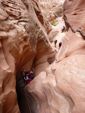
Spencer Canyon
| Rating: | |||||||||||||||||||||||||||||||
|---|---|---|---|---|---|---|---|---|---|---|---|---|---|---|---|---|---|---|---|---|---|---|---|---|---|---|---|---|---|---|---|
| | Difficulty:3B III (v3a2 III) Raps:6, max ↨70ft
Red Tape:No permit required Shuttle:None Vehicle:High Clearance Rock type:Sandstone | ||||||||||||||||||||||||||||||
| Location: | |||||||||||||||||||||||||||||||
| Condition Reports: | 14 Oct 2023
"This canyon was ridiculously pretty and a lot of fun. Water levels were low, with just one swimmer and a couple of short wades. We brought wetsuits bu |
||||||||||||||||||||||||||||||
| Best season: | Spring;Summer;Fall;HOT in Summer
|
||||||||||||||||||||||||||||||
| Regions: | |||||||||||||||||||||||||||||||
Introduction[edit]
Spencer Canyon is a beautiful and fun canyon in the Escalante area. It offers some interesting rappels and remarkable scenery. Bring lots of webbing and be prepared to rebuild anchors with limited resources to work with. Make sure you don't pull your ropes until the next anchor is well understood.
Approach[edit]
This description covers the technical route following the west fork of Spencer Canyon.
Park at the trailhead at the end of Spencer Flats road, and follow the Old Sheffield road trail for about 0.4 miles before turning left (north) on sandy cow trails until you reach a slickrock area. Continue north-east on the slickrock until you reach a drainage. This is the west fork of Spencer Canyon. You can drop in immediately, and proceed northward along a brushy canyon, or rim-walk along slickrock and sand until a drop-in location circa 37.71532,-111.34284. Soon after that point you will reach the first rappel.
Descent[edit]
- R1: 45 feet from a tree down a colorful dryfall. Continue downcanyon until you reach a second dryfall. There is a bypass route RDC, as well as a narrow slot LDC that appears to go as well. Further downcanyon, the canyon forks. Continue RDC with some minor boulder-hopping until the next obstacle is reached.
- R2: 35 feet from a tree. Can be bypassed LDC. There may be a pool at the bottom.
- R3: 70 feet from webbing extended from a tree and a rock horn high RDC and down from a rock promontory. This rappel has two stages and often lands the rappeler into another pool. There appears to be a bypass gully LDC as well.
- R4: 40 feet from a cairn anchor through a short corkscrew slot with several tiers and small potholes.
- R5: 50 feet from webbing extended from a deadman anchor in the last pothole of the slot, through a possible pool and down to the edge of the drop.
- R6: 40 feet down into a very narrow slot, which some might downclimb but shouldn't due to possible slippery walls. This slot holds water and will likely be a swimmer unless you can stem over it. More rope will be needed to pull from what may be a dry spot created by a small log jam. It would be easy to get your rope stuck here.
Exit[edit]
After the technical section, there is another swimmer with wider walls than R6. Some might be able to stem this section as well. Continue down canyon nearly a mile through stretches of narrows and past a number of obstacles. Depending on water levels there may be a few more wading pools, one of which can be bypassed LDC with an easy but slightly exposed climb.
At the four-way junction, turn right and continue upcanyon briefly. Past a small dryfall in the watercourse, a deep side canyon appears on the right. You may see a cairn here. Start climbing up the ridge left of that canyon and continue up to the rim. There are a couple of climbing moves required, but nothing too difficult. Hop over a small crack between fins and continue to the top where you will see a tiny rock arch. Continue west along the sandstone fin until you reach sand, then slickrock, then sand again. Merge with Old Sheffield road and slog on back to the trailhead.
Red tape[edit]
Beta sites[edit]
 Climb-Utah.com : Spencer Canyon
 AmericanSouthwest.net : Spencer Canyon
 RoadTripRyan.com : Spencer Canyon
 Super Amazing Map : Spencer Canyon
 BluuGnome.com : Spencer Canyon
- https://www.stavislost.com/hikes/trail/spencer-canyon
Trip reports and media[edit]
- https://www.facebook.com/media/set/?set=a.10151001311871103.477885.669366102&type=1&l=cca54bb1ab
 Candition.com : Spencer Canyon
 YouTube.com : Richard Pattison, Spencer Canyon movie
