Spiral
| Rating: | |||||||||||||||||||||||||||||||
|---|---|---|---|---|---|---|---|---|---|---|---|---|---|---|---|---|---|---|---|---|---|---|---|---|---|---|---|---|---|---|---|
| | Difficulty:3A (v3a1) Raps:4, max ↨82ft
Red Tape: Shuttle: | ||||||||||||||||||||||||||||||
| Location: | |||||||||||||||||||||||||||||||
| Condition Reports: | 8 Jun 2025
"all anchors good, a great canyon, allow 10 hours, the traditional exit maybe hard for some. If so, go back down the ramp and follow the clifflines, pa |
||||||||||||||||||||||||||||||
| Best season: | Oct-Apr (avg for this region)
|
||||||||||||||||||||||||||||||
| Regions: | |||||||||||||||||||||||||||||||
Introduction[edit]
This canyon is described in limited detail in Canyons Near Sydney by Rick Jamieson. Help the Australian canyoning community by contributing track notes to ropewiki.com
Approach[edit]
Parking is on the Rocky Creek Trail, at the start of the Deanes Creek walking track. Deanes Creek walking track is very well-defined at the time we did this canyon in 2023, that can of course change over time. There is no track either in our out of Spiral Canyon, so, you will need off-track bush navigation skills. We left the Deanes Creek walking track at around the 5km mark from where we parked our vehicle. Then, it was around 1km of changing bush from open to very thick to the first traditional abseil in.
Descent[edit]
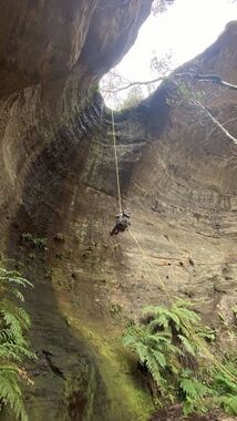
The first abseil is just spectacular and a lot of fun, there are 3 more abseils of varying heights throughout the canyon, all were slinged and appeared to be in good condition.
As you descend, a large canyon comes in on the left, this is worthy of a wander up and an explore, the cliffs here are spectacular.
As you get closer to Deanes Creek, the canyon gets a bit narrower and taller and very pretty, then, it is all over and you arrive at the confluence with Deanes Creek.
A great canyon, perfect for winter, not difficult, a single 50mtr rope is fine for all abseils.
Exit[edit]
Once you hit Deanes Creek, go left and upstream in the creek for a bit until you picked up a easy-to-follow canyoners track on the left bank. It is somewhere around 500-700mtrs up to the exit gully.
Then is is an uphill walk / scramble up this gully til another obvious gully came in on the left with a big fallen tree in it. We scrambled past the tree and went around left to a tape left in place to help scramble up a mini cliffline. Some more scrambling as we made our way to the right, then up another level, where a well-defined exit track went left along the bottom of the final cliffline.
Keep following the track higher and higher until a point is reached where you could just walk up onto the top of the cliffline.
From here, it is a 1km bush bash of thick wattle, you will grow to hate wattle and the colour yellow. After a while, you reach the Deanes Creek trail and, depending on where you popped out, a 4km or less easy walk back to your car.
