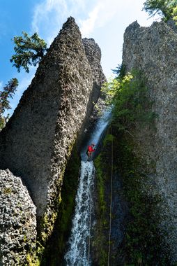
Spires of the Breitenbush
| Rating: | |||||||||||||||||||||||||||||||
|---|---|---|---|---|---|---|---|---|---|---|---|---|---|---|---|---|---|---|---|---|---|---|---|---|---|---|---|---|---|---|---|
| | Raps:10-12, max ↨140ft
Red Tape:No permit required Shuttle:None Vehicle:Passenger | ||||||||||||||||||||||||||||||
| Location: | |||||||||||||||||||||||||||||||
| Condition Reports: | 27 Jun 2020
"A spectacular day exploring a very beautiful canyon with exceptional views on the approach hike. The canyon itself is unique and very enjoyable. Its |
||||||||||||||||||||||||||||||
| Best season: | Early Summer
|
||||||||||||||||||||||||||||||
| Regions: | |||||||||||||||||||||||||||||||
Introduction[edit]
Spires was overrun by the Lionshead Fire in Sept 2020 and is open. Please check on local closures before planning a trip to this area. When all of the trails in the area eventually reopens, use extreme caution when descending the creek. Between landslides, fallen trees, and loose rocks, this area may be unstable and dangerous for years to come. The canyon may have changed dramatically. Do not rely on the beta below being accurate.
Spires of the Breitenbush is a small, unnamed tributary of the SF Breitenbush River in the Mount Jefferson Wilderness (not to be confused with the SF NF Breitenbush River, aka “Valhalla”, its next door neighbor to the north). The canyon features unique conglomerate formations and back to back rappels in the lower section. On a clear day, the Whitewater Creek Trail approach provides magnificent views of Mount Jefferson and the Whitewater and Russell Creek valleys. The Whitewater Trail leads to Jefferson Park, a destination in its own right on the flanks of the mountain with numerous small alpine lakes and magnificent scenery. Spires has a relatively small catchment, and likely dries up by midsummer after all the snow has melted from Jefferson Park. The scenic approach and canyon must be earned at the end of the day however, with a long and steep offtrail exit hike.
Approach[edit]
Park at the Whitewater Creek Trailhead. Hike up the moderately graded trail 5 miles to Jefferson Park, crossing Whitewater Creek at around 3.7 miles. Work your way between the numerous alpine lakes another 1.4 miles or so to the drop in. In late spring/early summer, you will most likely encounter large areas of snow. Too early in the season, and the snow may be difficult to navigate, or may also be present in the canyon itself. If starting early in the morning, be respectful of backpackers who may be camping at the many lakeside campsites in Jefferson Park.
Descent[edit]
DCR = Down Canyon Right
DCL = Down Canyon Left
Upper Section
The first rappel begins right away as the creek falls through a large cliffband. Start with a 20’ downclimb, or climb up and around the slope to a tree DCR where the creek turns sharply to the left.
R1: DCR - 140’ from a tree. This rappels goes down and around the corner to a group of trees DCL. This rappel is sloped with multiple ledges and very sharp rock. Rope abrasion management is a must, as well as good rope management to keep your rope from getting stuck during retrieval.
R2: DCL - 60’ from a tree in the group of trees. There is much loose rock in this spot. A short temporary handline may be handy to reach this tree.
R3: 70’ from a tree DCL
From here, downclimb through a large boulder field until the creek narrows up again.
Lower Section
R4: 70’ from a log in the center of the creek. This rappel goes down a 2-stage narrow corridor and wraps around the corner to the left.
Downclimb: 10’ nuisance drop - Use vegetation to downclimb DCL. Partner assist recommended after first person.
R5: 30’ from a tree DCL or DCR, take your pick.
R6: The “Big Guy”: DCL - 140’ from a bolted anchor. This rappel will take you into a very scenic conglomerate hallway. If flows are high, rappel 20’ and clip in DCL to a redirect around a clump of small trees.
Note: The anchor for R6 is very exposed. A partner belay for the first person and a safety line to clip in to for the remaining group is recommended.
R7: 15’ from a log
R8: 15’ from a log
R9: 40’ from a log down a ramp
R10: 40’ from a log down a 2-stage corkscrew rappel
R11: 50’ 2-stage rappel from a log
Once you reach the confluence of a similarly sized creek on canyon right, cut up into the forest on canyon left as soon as possible. Traverse around the hillside until you reach the main SF Breitenbush River valley. Find a suitable place to cross the river, which can be quite flowing high during the spring/summer melt off the mountain.
Exit[edit]
The exit from this canyon involves a long, steep ascent from the SF Breitenbush river up the south side of the valley back to the Whitewater Trail. The first descent team traversed the hillside from the river crossing and had a very difficult time with steep, brushy terrain and severely burned forest.
An alternate exit involves scrambling down the SF Breitenbush River until just below 3,800’, then climbing straight up the hillside through the main burn area. This is thought to be a better exit route, though this has not been confirmed, and would still require a lot of time and energy. Future groups have been warned! This alternate exit is the route shown on the KML map.
Red tape[edit]
Visitors to the Mt. Jefferson Wilderness require a Central Cascades Wilderness Permit for all overnight use and some day-use between June 15 and Oct. 15.
Beta sites[edit]
Trip reports and media[edit]
Background[edit]
This canyon was first descended on June 27th, 2020 by Ryan Ernst, Haruka-James Clay Lipscomb, Michelle Nilles, and Jake Huddleston.
