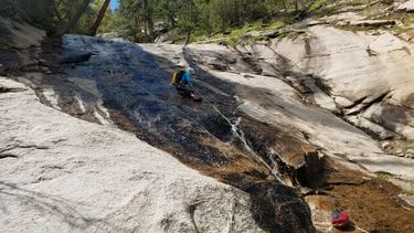
St. Vrain Slide
| Rating: | |||||||||||||||||||||||||||||||
|---|---|---|---|---|---|---|---|---|---|---|---|---|---|---|---|---|---|---|---|---|---|---|---|---|---|---|---|---|---|---|---|
| | Difficulty:3B II (v3a2 II) Raps:max ↨120ft
Red Tape:No permit required Shuttle:None Vehicle:4WD - High Clearance Rock type:Pegmatite and Gneiss | ||||||||||||||||||||||||||||||
| Location: | |||||||||||||||||||||||||||||||
| Condition Reports: | 28 Jun 2025
"A long approach and return for one mandatory rappel, make this route hard to recommend. Perhaps the comment about being more fun in higher flows appli |
||||||||||||||||||||||||||||||
| Best season: | Apr-Sep
|
||||||||||||||||||||||||||||||
| Regions: | |||||||||||||||||||||||||||||||
Introduction[edit]
May be one of the cooler canyons within an easy drive from the Front Range. It's all ghostable, and would actually be pretty fun at higher flows. At lower flows, i.e., most of the time, it's still fun, but more for the views and cool rock. Look for some slides - the rock is very smooth, and there are both wet and dry slides, although all require either a spot and confidence sliding into a hard landing or a rope.
High flows on this creek probably only last a week or two sometime between April and late May in a good snow year, so if you want to do it when it's really flowing, you'll need to time things pretty well.
ETHICS NOTE: This is a ghosting canyon. If you absolutely need to leave tat on anchors, expect it to be cleaned off by the next party. Every drop is ghostable and should be ghosted. If you aren't comfortable with standard ghosting techniques, either build up your skillset before coming here or find a friend who is. If you're comfortable using a fiddlestick or similar tool, you'll probably have no problem here, with the exception of the last drop (see note below).
Approach[edit]
The track shown on the map is approximate. This area isn't hard at all to bushwhack through. The approach essentially involves diverting from the Dry St. Vrain trailhead and working your way ENE over to the canyon. You may be able to follow game or hunter trails to make life easier (look for cairns). Dropping down into the actual stream is a bit tricky in places - watch your footing and don't get skewered on a downed tree. Once you're in the stream, the going is easy to get to the first drop.
NOTE ON PARKING: parking is limited at the Dry St. Vrain trailhead, and the last 1/2 mile to the trail definitely requires high clearance or an absolute lack of care for the condition of your underbody. Parking on the 2WD road is unfortunately very limited, and may piss off locals, so beware.
Descent[edit]
The canyon starts with some short warm-up downclimbs, then, you'll break into some awesome views of Cook Mountain and a few more substantial drops. Whether you rap or downclimb is up to you, but anchors abound. Watch out, while the pegmatite is sticky, the gneiss is slick and super slick when wet. Makes for some great rappel slides on some drops when it's even just a little wet, hence the name of the canyon. No jumps, slides into pools, etc., but a very interesting landscape to explore.
The fun of this canyon is finding your own anchors and leaving no trace as you descend. Anchors are numerous, mainly in the form of large logs, boulders, and big, hearty trees.
On the first descent, we found the longest rap to be 120 ft, but the max length will depend on the anchors and sequencing you choose, so consider bringing a 200 ft rap rope to be safe.
NOTE ON THE LAST DROP: The last drop (the one after you boulder hop for a ways, after all the slabby sections of canyon), in particular, was a puzzle to ghost on the first descent. We ended up using a very sneaky anchor that required some specialized ghosting kit, and it still took a fair bit of time to get things set up. There are bolts on the last drop, but they almost certainly weren't placed by canyoneers.
Exit[edit]
Once you go down the last drop, walk a short distance downstream to the North St. Vrain. From there, walk upstream. You should be able to find and follow a small boot path on the south valley wall not far from the river. It's not very continuous, though, so don't be afraid to climb over some wood and boulders closer to the river. You shouldn't need to cross the river, although the North St. Vrain changes a lot after floods (e.g., after the 2013 floods), so be wary. Work your way up the south bank until you come to the campsites at the intersection between the Dry St. Vrain trail and the North St. Vrain River. From there, walk the Dry St. Vrain trail back to your car.
Red tape[edit]
Beta sites[edit]
Trip reports and media[edit]
Background[edit]
Dan Scott and Ellen Daugherty did the first known descent on May 16, 2020.
