Stafford Creek
| Rating: | |||||||||||||||||||||||||||||||
|---|---|---|---|---|---|---|---|---|---|---|---|---|---|---|---|---|---|---|---|---|---|---|---|---|---|---|---|---|---|---|---|
| | Raps:7-10, max ↨75ft
Red Tape:No permit required Shuttle:Optional 3.4mi Vehicle:Passenger Rock type:Basalt | ||||||||||||||||||||||||||||||
| Location: | |||||||||||||||||||||||||||||||
| Shuttle: | |||||||||||||||||||||||||||||||
| Condition Reports: | 22 Jun 2025
"Great run with class, everyone had a great time! We started at R4. New anchor and line at the 75 foot rappel is great! Thanks Kevin and Dusty. |
||||||||||||||||||||||||||||||
| Best season: | Mar-May
|
||||||||||||||||||||||||||||||
| Regions: | |||||||||||||||||||||||||||||||
Introduction[edit]
This short, fun canyon is one of the best in the Oregon Coast Range. Visit in the early season to see it with good flow. Being largely south-facing, it's lovely on a warm spring day. Stafford usually becomes beginner-friendly somewhere in May-June. Late in the summer, the flow likely reduces to a trickle. A great early season creek for training and practice.
- Watershed: 1.25mi^2.
- Update 2025: Stafford contains at least one set of unlinked bolts. Please do not add webbing to them.
Best Practices[edit]
- Teaching people to rappel for the first time in an aquatic canyon is not a good plan. It's safer to become fully proficient with rappel devices in a dry, controlled environment outside the canyon.
- Wrapping the rope around trees for a two strand rappel is efficient, but isn't good for the tree when you go to pull your rope. Friction damage around the back of the tree cuts into the bark. Done too many times by too many people and the tree will become girdled and eventually die. It's kinder to the tree to set a webbing anchor or use a retrievable system.
- Two strand rappelling (as is done in alpine climbing) can be dangerous in aquatic canyons for a number of reasons. There is no easy way to rescue a rappeller who becomes stuck on the rope in the middle of the pitch (ex: jammed descender). Getting stuck in significant flow can be a life-threatening situation. Taking a class in aquatic canyon techniques is strongly recommended.
- Beginners "leading" beginners is a common cause of accidents in canyoneering.
Approach[edit]
From Portland, take Hwy 6 and turn onto Larch Mountain / Drift Creek Road. Drive downhill, cross the bridge, and stay left at the junction to reach a large parking area. From here, either shuttle or hike up to the top. The classic descent route is via the eastern tributary of Stafford.
⚠️ Warning: There has been at least one reported car break-in at the lower parking area. Do not leave anything valuable—or anything that looks like it might be valuable (e.g., bags, purses, rope bags)—in plain sight. Store gear in the trunk and keep your vehicle looking empty. To reduce risk, consider parking at a pullout along Hwy 6 instead.
At the upper parking pullout, look for the large metal culvert under the road. A use trail drops into the drainage from here. Stay on the north (DCR) side of the creek to bypass a minor logjam, then drop in just below it. R1 is a short walk downstream.
Royal Shortcut (Direct to R4)[edit]
This is the fastest route to the canyon's highlights. Park at the large grassy pullout at the switchback (as marked on the map). There’s room for several vehicles. An elk trail leads down toward the creek.
No Shuttle Approach[edit]
If you don't have a shuttle, you can park at 45.624194, -123.418314. Follow the old logging road southeast from there to the fork, then follow it east and northeast into the creek. You'll drop in a bit upstream of R4 and the best part of the canyon.
When you've finished, walk back up the road about 0.9mi past the bridge and then cut in at the old logging road/trail at 45.624433, -123.421808. It's a well-traveled trail, and leads back to the intersection (i.e., where you turned east after heading southeast from your car). While tempting, please DO NOT use the mountain bike trails. The Forest Service and bikers do not want hikers on these trails. It can be quite dangerous if bikes are coming down at speed.
Descent[edit]
Many of the anchors are intended for use at low flow. Evaluate carefully whether or not to use them when flow is high. Stafford can seriously rip during flood events.
East Tributary[edit]
- R1: 75ft of rope from tree DCR. A short walk below, and you'll enter the main creek, where the flow will double or more.
Stafford Creek[edit]
- R2: 15ft. Single bolt DCL (low). Drop can be bypassed DCR.
- R3: 45ft of rope from root ball DCR.
- High flow: Use a tree high DCL.
There's a bit of a creek walk before the next rappel.
- R4: 60ft from fallen log DCR.
- High flow: Use a tree further DCR to stay out of the torrent.
- R5: Pete's Pothole. 45ft of rope from bolts DCR. The falls goes into a chute with a couple small potholes. The last pothole is the size of a bathtub, but very deep (~7ft).
- High flow: The potholes could be dangerous in high flow. Use a tree DCL to stay out of the water.
- R6: 70ft of rope from bolts on giant boulder DCL. There is a lower 6ft second tier which is extremely awkward. The lower tier can be bypassed carefully DCL while staying on rappel.
- R7: 60ft of rope from bolts mid-creek.
- R8: 30ft of rope. Single bolt DCR near the lip.
- High flow: bypass or rappel from tree DCR.
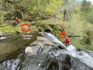
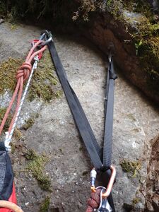
- R9: Stafford Falls. The pitch is broken up into two stages. Stage A: 25ft from unlinked bolts DCL. This is a short approach rappel (it's a bit steep for a traverse) to the main anchor situated DCL right at the brink where the pitch goes vertical. This segment should be rigged as a rebelay. Stage B: 75ft from a Y-anchor DCL. The stage B anchor has excellent line of sight down the pitch. There are some cracks around the R9b bolts - see reference photo below so we can monitor them.
- High water: follow a slightly-exposed user trail up to a tree high DCR for a 110ft rappel out of the water. (Both ends of a 65m rope just touch the water.)
- R10: Twin falls: 50ft from bolts DCL and DCR. (Be aware: dippers often nest directly under the DCL falls in spring.)
- High water: rappel from a tree far DCL. The drop becomes almost a uni-fall in high flow.
Exit[edit]
Continue down the creek to the Devil's Fork of the Wilson River. Most of the year, it's possible to wade/swim across and scramble up a short trail to the highway. Hike back along the shoulder of OR-6 to your car (~5min).
- If the river's running high, it's possible to bushwhack west from the top or bottom of R9.
Red tape[edit]
None.
Beta sites[edit]
Trip reports and media[edit]
 Karl Helser's NW Adventures : Stafford Creek Canyoneer 5-28-16
 Karl Helser's NW Adventures : Stafford Creek Canyoneer 3-18-17
https://youtu.be/WeR4QbG1NvM Feb 2025
Background[edit]
Creek was first run by Keith Campbell and Karl Helser in May 2016.


