Starvation Creek
| Rating: | |||||||||||||||||||||||||||||||
|---|---|---|---|---|---|---|---|---|---|---|---|---|---|---|---|---|---|---|---|---|---|---|---|---|---|---|---|---|---|---|---|
| | Raps:3, max ↨130ft
Red Tape:No permit required Shuttle:None Vehicle:Passenger | ||||||||||||||||||||||||||||||
| Start: | |||||||||||||||||||||||||||||||
| Parking: | |||||||||||||||||||||||||||||||
| Condition Reports: | 19 Jun 2025
"The falls are spectacular and def in flow is very exciting, nothing terribly difficult about the rappels HOWEVER that approach SUX! The climb up 1250 |
||||||||||||||||||||||||||||||
| Best season: | May-Sept
|
||||||||||||||||||||||||||||||
| Regions: | |||||||||||||||||||||||||||||||
Introduction[edit]
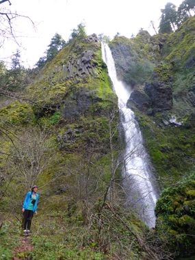
Starvation Creek Falls is located in the state park of the same name. The falls is just adjacent the rest area off I-84 at exit 55. (N.B. The rest area is accessible via I-84 eastbound only.) The falls is quite popular with passersby, so it's best to keep a low profile, make a good impression, and don't overstay your welcome.
- Watershed: 1.05mi^2. Highest point in the drainage is about 3800ft elevation.
- Checkpoint: From the parking area, walk east up the bike path and south to the base of the falls.
Approach[edit]
Hike up the Starvation Ridge trail until about 1250ft elevation. Just as you begin climbing the ridge in earnest, break off the trail, and scramble/bushwhack downward some 600ft into the drainage for Starvation Creek. Be prepared for a steep drop with loose soil and a high potential for poison oak. Helmet and gloves are recommended before dropping off the ridge.
- If the Starvation Cutoff trail is closed, the approach is longer. Head west on the bike path to Hole-in-the-Wall Falls, cross the bridge and follow the trail upwards 0.2mi to a junction. Turn left here on the Starvation Ridge trail and follow it back east.
Descent[edit]
- R1 - Tree DCR about 10 feet back from the edge. The drop is about 60ft.
- R2 - Tree DCR 130ft. Taking a DCL line puts you in heavy flow down to a small platform with a single bolt about 10 ft above another flat area (R3).
- A DCR line keeps you out of the heaviest flow and allows you to choose to land on the upper or lower platform. Pulling from the upper platform is easier.
- R3 - Bolt station DCR, 100 ft.
Exit[edit]
Follow the trail 200ft back to the parking area.
Red tape[edit]
None.
Beta sites[edit]
Trip reports and media[edit]
https://youtu.be/RGMrazAsUHY?si=wC_Y_vYCe3VqZFjW
Background[edit]
First known descent by Haruka James Clay Lipscomb, Michael Peterson, and Ryan Ernst.

