Strawberry Mountain Falls
| Rating: | |||||||||||||||||||||||||||||||
|---|---|---|---|---|---|---|---|---|---|---|---|---|---|---|---|---|---|---|---|---|---|---|---|---|---|---|---|---|---|---|---|
| | Raps:4-5, max ↨190ft
Red Tape:No permit required Shuttle:None Vehicle:Passenger Rock type:Basalt | ||||||||||||||||||||||||||||||
| Location: | |||||||||||||||||||||||||||||||
| Condition Reports: | 27 May 2024
"Fun day. Webbing and anchors all in good condition.. A group with time & skills could add wet-line bolts and increase what this route has to offer |
||||||||||||||||||||||||||||||
| Best season: | Spring
|
||||||||||||||||||||||||||||||
| Regions: | |||||||||||||||||||||||||||||||
Introduction[edit]
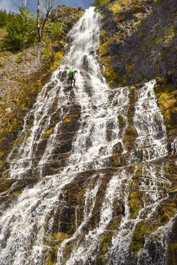
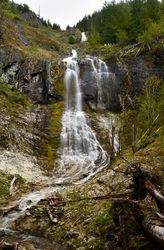
Strawberry Mountain Falls is a very scenic open-faced route in the Gifford Pinchot National Forest north of Mt. St. Helens. It features several multipitch rappels up to 275 feet. Typically moderate to low flow, this route is best run in the spring while there is still snow melting on top of Strawberry Mountain. The route dries up during the mid to late summer and could still be run as a dry canyon but likely wouldn’t be as much fun. A 300 foot rope is needed to run this canyon.
How To Get There
From I-5, take Hwy 12 to Randle. Head south on WA-131 S for 2.7 mi. Keep right on NFD 25 and continue for 5.9mi. Make a slight right on FR 26 and continue for 9.5mi. Park at the turnout where FR 26 crosses the creek (46.3739, -122.0554).
Approach[edit]
From the parking area, begin hiking up the road, checking out the falls as you go by. After about 400’, cut into the forest and immediately begin the climb up the hillside. While fairly steep, the terrain and undergrowth are not too difficult to navigate. Slowly traverse your way towards the canyon as you ascend. There is a steep gully that parallels the canyon. Continue up until the gully fades out and it is easier to cross. Drop in to the canyon at around 3,200’ above the first big drop(46.3735, -122.0516) and enjoy the beautiful views across the Quartz Creek valley.
Descent[edit]
DCL = Down Canyon Left
DCR = Down Canyon Right
This canyon features unlinked bolt anchors. Please do not link these anchors with webbing! The anchors are exposed to high water flow and debris during the off season, which can catch on linked anchors and severely damage them. Groups should be familiar with how to safely rig unlinked bolts.
Multipitch Rappel #1
- R1: 100’ from a tree DCL to a double bolt anchor DCR. Bolts are on a slab of rock directly next to the watercourse.
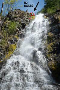
- R2: The Grand Staircase: 190’
Multipitch Rappel #2
- R3: 190’ from a tree center canyon to a double bolt anchor DCR. Bolts are on a slab of rock directly next to the watercourse where the falls begins to open up again.
- R4: 175’ from a bolt station DCR just at the lip. Rappel down the slabby rock 175’ to a bolt station.
- R5: 100’ from a bolt station DCR. This rappel is vertical. Manage abrasion appropriately as the rock on this lip is sharp in places.
Exit[edit]
Red tape[edit]
Beta sites[edit]
Trip reports and media[edit]
Photos from the first descent on May 9th, 2020: https://www.facebook.com/media/set?set=a.2711029335690219&type=3
Background[edit]
This canyon was first descended on 5/9/2020 by Ryan Ernst, Haruka-James Clay Lipscomb, Barry Specht, and Jake Huddleston.


