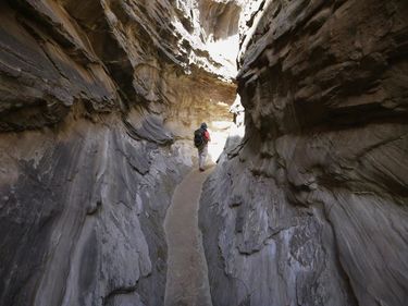
Stud Horse Point Canyon
| Rating: | ||||
|---|---|---|---|---|
| | Difficulty:2A I (v1a1 I) Raps:0
Red Tape:No permit required Shuttle:None Vehicle:Passenger | |||
| Location: | ||||
| Condition Reports: | ||||
| Best season: | ||||
| Regions: | ||||
Introduction[edit]
A short non-technical canyon hike just north of Page, AZ. While the canyon has no rappels, the entry downclimb and some zero exposure stemming keep things a bit interesting, though this might keep it from being an entirely "family-friendly" walk-through canyon.
Approach[edit]
From Page, drive north on HWY 89 for 8 miles, then turn left onto an unmarked dirt road. This road is bit difficult to spot as you're driving, it is just north of a section of guard rail where the highway crosses a shallow wash (the lower reaches of Wildcat Tank) and directly across from a green mile marker sign for Kanab. After turning onto the dirt road, at .9 mile turn right onto a more faint road to park shortly thereafter as far in as you're vehicle will take you. From the end of the road hike down into the wash to the north, then find your way hiking cross-country to the northwest to the head of the canyon. Follow washes and faint foot paths where possible to avoid hiking on the cryptobiotic soil that abounds in the area.
Descent[edit]
The canyon begins with a downclimb through a chute of about 15 feet; afterwards simply hike down canyon through sandy hallways and occasional basic stemming moves where the canyon walls are to narrow to keep your feet on the ground. You'll eventually reach the confluence with the north fork of this canyon system coming in from the left. Older beta for this fork shows an arch that has unfortunately since crumbled away, leaving not all that much to see in this very short section of canyon.
Exit[edit]
Hike out of the canyon and cross-country hike to the south back to your car, or do some more exploring and make you way back from where ever you end up...it isn't far and some big landmarks make navigation easy.
Red tape[edit]
Beta sites[edit]
![]() American South West : Stud Horse Point, Glen Canyon
American South West : Stud Horse Point, Glen Canyon
Trip reports and media[edit]
- https://www.facebook.com/pat.winstanley.7/media_set?set=a.964567590268605.1073742018.100001461198708&type=3
 YouTube.com : Richard Pattison, Stud Horse Point Canyon movie
