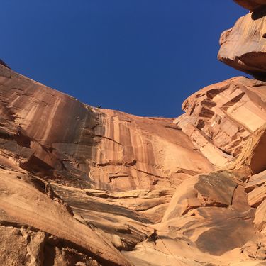
Sunseed Canyon
| Rating: | |||||||||||||||||||||||||||||||
|---|---|---|---|---|---|---|---|---|---|---|---|---|---|---|---|---|---|---|---|---|---|---|---|---|---|---|---|---|---|---|---|
| | Difficulty:3A II (v3a1 II) Raps:1-2, max ↨200ft
Red Tape: Shuttle: Vehicle:Passenger | ||||||||||||||||||||||||||||||
| Location: | |||||||||||||||||||||||||||||||
| Condition Reports: | |||||||||||||||||||||||||||||||
| Best season: | All year
|
||||||||||||||||||||||||||||||
| Regions: | |||||||||||||||||||||||||||||||
Introduction[edit]
Impressive 200-foot rappel with about 100 feet of free hang. On the approach, stunning viewpoint overlooking town and Spanish Valley, the La Sals and further on amazing views of a massive garden of fins. Not suitable for beginners due to to intimidating 200+ foot rappel and the need to adjust friction on rappel.
Approach[edit]
Best approach is up Mastadon Canyon requiring Class 4 scrambling, at top find old grown-over Jeep trail until a wash. Take wash south around and over a few fins to the head.
Head of Sunseed Canyon: 38.5443, -109.57580
This Way on Use Trail: 38.54242, -109.5776
Descent[edit]
Before the rappel there are some down climbs. A partner assist may be needed at the final down climb into the hanging pothole. The anchor is bolted on canyon left and is hidden from above. It can be reached from this hanging pothole. Have your best climber go last in order to do the tricky down-climb on the bottom. To get off rappel, there is a tricky stance on a sloping buttress and a tricky down-climb the final 15 feet. Check to be sure your rope has not shrunk much. All 200 feet will be needed. Walkie-Talkies are recommended. From the bottom of the rappel it is impossible to hear LAMAR if there is any wind. This is where Walkie-Talkies are recommended. If you are using a 200 foot rope, it is recommended to tie 30 feet of webbing onto the end of it in order to make it possible to hold onto the rope from the sloping buttress and avoid the wind from taking it out of your hands or pulling you off the ledge. This way you will be able to keep the rope for a Fireman belay and also as a hand-line to get down the 15 foot down climb, for everyone but LAMAR. Be sure to remove this webbing before the rope pull. Partner assist may be needed to get LAMAR off this ledge safely.
Exit[edit]
Once you reach the telephone lines above, be sure to go north and up over the knoll to the next drainage and then out to the road to avoid trespassing on private property.
Red tape[edit]
Beta sites[edit]
 Moab Canyoneering Book by Derek A. Wolfe : Sunseed Canyon
 RoadTripRyan.com : Sunseed Canyon
 Climb-Utah.com : Sunseed Canyon - Moab
