Swamp Creek
| Rating: | |||||||||||||||||||||||||||||||
|---|---|---|---|---|---|---|---|---|---|---|---|---|---|---|---|---|---|---|---|---|---|---|---|---|---|---|---|---|---|---|---|
| | Raps:11, max ↨60ft
Red Tape:No permit required Shuttle:Required 3 mi Vehicle:High Clearance | ||||||||||||||||||||||||||||||
| Location: | |||||||||||||||||||||||||||||||
| Shuttle: | |||||||||||||||||||||||||||||||
| Condition Reports: | 21 Sep 2024
"Many good downclimbs, downclimbs in the flow - a rare treat, 2 slides, and a few rappels in the flow. Not great for jumping as most pools were either |
||||||||||||||||||||||||||||||
| Best season: | Aug-Sept
|
||||||||||||||||||||||||||||||
| Regions: | |||||||||||||||||||||||||||||||
Introduction[edit]
Swamp Creek is is located within Mount Baker-Snoqualmie National Forest in Whatcom County, Washington. It is a tributary of the North Fork Nooksack River and is sourced by an unnamed glacier on the north slope of Goat Mountain and Twin Lakes between Bear Peak and Winchester Mountain.
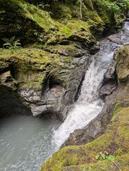
Don’t judge a canyon by its name! Swamp Creek canyon is a far cry from the image its name might suggest. Starting off in a scenic narrows, the canyon soon opens up to reveal many pools, unique geology, and a nice stretch of creekwalking and down climbing between rappels. The approach and exits are very short if doing the shuttle, making this beautiful canyon great bang for your buck.
Canyoners descending Swamp Creek should have experience rappelling directly in flow, be strong swimmers, and be able to assess/replace one V-thread anchor.
Approach[edit]
Getting There
From Glacier, WA, head 13 miles east on Mt. Baker Highway (SR-542). Take a left at NF-32 road (48.90654, -121.69362) and veer left past Shuksan Picnic Area. Continue for about 0.4 miles and take a left onto one of several side roads. These roads lead back to primitive campsites near Swamp Creek. If these campsites are occupied, it is possible to park along the main road. The GPS track above is misleading as the diagonal left road is an immediate dead end. Instead, continue to the next 90 degree left turn onto a primitive road, proceed 500 feet and park where there is parking for 2 vehicles and a path to the creek.
Shuttle
Head back out to the Mt. Baker Highway and turn right. After several hundred feet, make a sharp right before the WSDOT Maintenance facility onto FR-3065 (towards Twin Lakes trailhead). Drive about two miles up the gravel road and turn right onto a side road (48.91706, -121.68105). This road dead ends after a few hundred feet and can fit 2-3 vehicles. Park and suit up here. Take a use trail on the left down to the creek - a 3 minute approach hike!
Descent[edit]
DCR = Down Canyon Right
DCL = Down Canyon Left
Always check for hazards before jumping or sliding. This canyon often has cloudy water from the snowfields in its upper catchment, making visible depth checks difficult. Take extra caution when jumping in this canyon.
Upper Narrows From the drop in you’ll reach the upper narrows within 5-10 minutes.
J1: 5’ jump into shallow pool. This drop can be down climbed or bypassed DCR.
R1: 15’ from a log
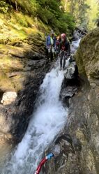
R2/J2: DCR - 25’ rappel, from unlinked bolts. There is a redirect 8' further along the wall DCR that may be useful in high flow. The rope pull is not an issue from the rear bolts. This rappel puts you directly in the flow, which can be a quick duck under. This drop has been jumped.
R3: DCR - 20' from a single bolt. After a few hundred feet of downclimbing, you will reach R4.
R4: DCR - 25’ dry rappel from a single bolt.
Middle Section - Creek Walking & Down Climbing After R4 there is about a 1/4 mile of scrambling and downclimbing in the creek. This may take between 45 minutes to 1 hour. Keep an eye out for a pothole where the water seems to disappear!
Lower Technical Section
R5: DCR - 20' from single bolt
R6: DCR - 20' from single bolt
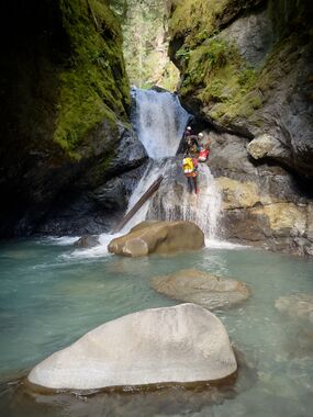
R7: DCL - 50’ from unlinked bolts. This rappel takes you down a giant log wedged in the creek. There is a large pothole hidden beneath the log. In high flow, it is advisable to avoid going into this pothole while on rope. In moderate or low flow the pothole is runnable.
R8/S1: DCR - 50’ from unlinked bolts. This drop also goes as a slide from about 1/3 of the way down from a nice ledge DCL. The slide is 20' into a deep pool. It is an easy scramble back up from the bottom to lap this slide.
R9/J2: DCR - 25’ from unlinked bolts. This drop has also been done as a 15' jump into the narrow pool below. Soon after R9, down climb a slab DCR that is accessed by going up and over a vegetated mound. Optionally, rappel off a logjam DCL.
R10: 15’ from logjam or downclimb through the logs.
R11: DCR - 40’ from single bolt on a boulder. This rappel has an awkward start through a narrow crack into an overhang. At the bottom you will be deposited into the main force of the flow. Awesome rappel!
R12/S2: DCL - 60’ from a V-thread in two stages.
- Option 1: In moderate or low flow, rappel, staying on rope through the pool. To avoid rope entanglement in the pool, make sure you have a good toss of the rope so the current pushes it down the 2nd stage and the weight of the rope keeps it from getting sucked into the pool. To do the slide, on the first stage rappel down 6' to a ledge then slide 12' into the deep pool. The flow will push you to the opposite side. Regain the rope and finish the 2nd stage.
- Option 2: In high flow, rappel 30' from the V-thread into the pool. It is important to set rope length here to avoid entanglement. There is an alcove on canyon left that less confident swimmers can be pushed into. Sending a strong swimmer first to assist others out of the pool is recommended. There is an undercut DCR that could be problematic in high flow. Exit the pool DCL of the pour over onto a ledge. Pull your rope from here. Rappel 15’ from a single bolt DCL.
Exit[edit]
The creek changes character from here and gently meanders on a flat grade. Creek walk for 5-10 minutes. Find a spot DCL to cut up into the woods and find the use trail to the campsites/parking area.
Red tape[edit]
Beta sites[edit]
Trip reports and media[edit]
Background[edit]
First Descent[edit]
This canyon was first descended on 9/3/22 by Jake Huddleston, Tiffanie Lin, Andrew Humphreys, Kevin Steffa, Erik Bernhoft, Tre C Kwan, and Michael Henson.
Accommodations[edit]
Dispersed camping is available at several nearby locations, although the area is popular and campsites may be full on weekends and holidays in peak season.
There are a couple nearby national forest campgrounds:
- Silver Fir Campground (nearest to Swamp Creek)
- Douglas Fir Campground
- Excelsior Group Camp appears to be closed indefinitely due to the November 2021 washout and was removed from the USFS website.
Lodging can also be found in Glacier.
Dining[edit]
Wake 'n Bakery in Glacier has great coffee and a hearty breakfast. North Fork Brewery in Deming is a local favorite for pizza, beer, and cider.


