Syncline Slot
| Rating: | |||||||||||||||||||||||||||||||
|---|---|---|---|---|---|---|---|---|---|---|---|---|---|---|---|---|---|---|---|---|---|---|---|---|---|---|---|---|---|---|---|
|
| |||||||||||||||||||||||||||||||
| | Difficulty:3B III (v2a2 IV) Raps:2, max ↨20ft
Red Tape:No permit required Shuttle:None Vehicle:Passenger Rock type:Sandstone | ||||||||||||||||||||||||||||||
| Start: | |||||||||||||||||||||||||||||||
| Parking: | |||||||||||||||||||||||||||||||
| Condition Reports: | |||||||||||||||||||||||||||||||
| Best season: | Year-Round
|
||||||||||||||||||||||||||||||
| Regions: | |||||||||||||||||||||||||||||||

Introduction[edit]
An unusually high-quality sandstone slot for southern California marred by required bushwhacking, including through dense poison oak. The slot is sustained for 1100 ft, likely making it one of the longest in southern California. The canyon is technically easy; the cruxes are the bushwhacking gymnastics and a steep and loose 500ft ascent out of the bottom of Liebre Canyon. The canyon is named Syncline Slot for the half-pipe shaped fold in the sandstone layers; the slot has formed along its axis. The good stuff is good with fern gardens, colorful narrows, potholes, water, and a remote wilderness feel. Those with bad reactions to poison oak and/or yellow jacket stings and/or Type II+ Fun should avoid this one.
As a bonus, the driving approach is along the Old Ridge Route, an interesting piece of California history. It was considered a marvel of engineering when it was completed in 1915, providing the critical motor vehicle link between southern and northern California. The road appears braided from its multiple generations. An oiled and graded surface was paved over with a highly curvy slab of reinforced concrete with some of these curves later being shortcut with an asphalt paving surface. Driving along, transitions are frequently made to follow the best surface. Do note that there is a gate several miles short of the ideal parking spot. Check its status ahead of time or come prepared to walk or bike the section beyond.
Recommended: 60ft rope. Abrasion-resistant long-sleeve shirt and pants. Work gloves. Trekking pole. Folding saw. Full-body painter's suit (only half-joking) and poison oak removal wipes. Calling USFS to check gate status!
In my opinion it is a 2-star canyon that could be a 4-star canyon for the region if scrub and poison oak were to be trimmed back (*cough cough*).
Approach[edit]
Driving: Turn off Lancaster Rd onto the Old Ridge Route. At about 2.3 miles from Lancaster Rd the road is no longer maintained. Beyond is a paved historic road with lots of curves and potholes. It is passable with a low clearance passenger vehicle (Prius or similar) but expect top speeds of 15-20mph. At 6.7 miles is the ruins of the Tumble Inn with a rock masonry archway remaining. Just beyond is a large gate, hopefully open! If not it adds an additional 5.6 miles roundtrip walking or biking. Park at about 9.5 miles from Lancaster Road.
Hiking: Follow the spur road steeply upward to gain the ridge. Steep moderate bushwhacking leads down to the canyon floor. More unpleasant bushwhacking continues. This upper section only has 1-2 patches of poison oak that are easily avoidable. After 0.3 miles from the car, a prominent sandstone outcrop with erosional alcoves is seen on canyon right. If you have found your progress too slow to this point or the bushwhacking too unpleasant, just upstream is probably your last good escape option (or return the way you came). A 10ft high dryfall ledge can be bypassed on canyon left. The canyon starts to get more interesting with some bedrock floored sections and shallow slots. Continuing along, a prominent left jog in the canyon is encountered where the floor drops quite abruptly into a slot. This is considered the start of the technical canyon and the place to put on vertical gear.
Descent[edit]
Rappel 20ft to enter the canyon. There is a perfectly positioned natural arch anchor that works best with a fiddlestick but could also be slung with webbing. This is probably downclimbable but worth rappelling.
The slot canyon below continues for 1100 ft. Spring water appears right away (and so does the irrigation tubing from former illegal growing operations). In summer, expect wet feet if you do not avoid creatively and beware of yellow jackets defending the water. In spring, there could be some knee deep wading. Pass through a beautiful riparian hallway, taking care to not disturb the maidenhair fern and scarlet monkeyflower gardens. The slot has some nice carved curves and potholes in this section. There are a few mostly avoidable patches of poison oak. Also several downclimbs, none difficult. Finally there is an abrupt ledge drop just before the canyon opens, the second (and final) rappel.
Rappel 20ft. There were several very soft rocks here that could be stacked for a rockpile anchor, but consider options carefully. Harness can be removed on the landing below. A couple short downclimbs over boulders immediately follow.
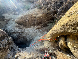
Arch anchor at Rappel 1 and start of main slot. Photo by Nicolas Barth.
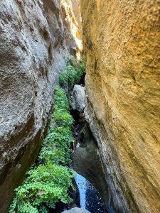
Maidenhair fern hallway. Photo by Nicolas Barth.
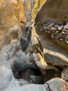
Slot downclimb. Photo by Nicolas Barth.


Exit[edit]
From the base of the last rappel it is a short (but oh so long) 700ft jaunt to Liebre Gulch. Poison oak is unavoidable and thick for most of this. Tread carefully. An interesting fluted dryfalls enters on canyon right. Remnants of a long-abandoned illegal growing operation are passed (bean cans, etc.). Continue upstream at Liebre Gulch. In summer, Liebre Gulch is dry and makes for mostly easy walking on a flat firm surface. As the streambed turns to the right it is more vegetated with some more poison oak to avoid. Look for the cleared band of vegetation marking the crossing of a buried pipeline. Follow the clearing (really a strip of tall spikey weeds) steeply (very steeply!) up to the right out of the canyon. Some of this will be two steps forward, one step back. Thankfully there is no false summit; once the skyline is reached the ridge rolls over into a much more reasonable gradient. The worst is behind at this point! Follow the ridge back to the car.
Red tape[edit]
US Forest Service land. Open access. The Old Ridge Route appears to sometimes be gated at the site of the Tumble Inn; this would add 5.6 miles roundtrip of road walking or biking.
Beta sites[edit]
Trip reports and media[edit]
Background[edit]
First recorded descent 08-11-2024 by Nicolas Barth (3hrs45min). It was quite the solo adventure between the hot day, shirt-tearing bushwhacking, yellow jacket stings, poison oak nightmare fuel, and maybe I accidentally dropped my rope down the second rappel. The canyon was scouted with high-resolution lidar data that told me exactly where and how high the drops would be. There are likely other "stairstep" style canyons in the region, but this appears to be the most sustained slot canyon.
Old Ridge Route history: https://ridgeroute.org/ridge-route-history/