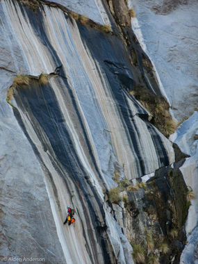
Tachevah Canyon (Dry Falls)
| Rating: | ||||||||||||
|---|---|---|---|---|---|---|---|---|---|---|---|---|
| | Difficulty:3A II R (v5a1 II) Raps:3, max ↨175ft
Red Tape:No permit required Shuttle:None Vehicle:Passenger | |||||||||||
| Location: | ||||||||||||
| Condition Reports: | 23 Apr 2016
"Only ran the last section and found an easy but steep way up to the falls (DCL). A fun multi-pitch drop that is never free hanging. We also explored s |
|||||||||||
| Best season: | ||||||||||||
| Regions: | ||||||||||||
Introduction[edit]
Tachevah Canyon is a lesser known canyon in the San Jacinto Canyons and has eluded many canyoneers due the strenuous and long approach required to descend the canyon. The highlight of this canyon is the last section which ends with a spectacular 500' multi-pitch drop called Dry Falls. A group of canyoneers in early 2016 completed the full route of Tachevah and reported that it included not only a long and strenuous hike but also brutal off-trail bushwhacking. The conclusion was that only descending Dry Falls is recommended.
Approach[edit]
If descending only the Dry Falls section, hike along the trail that skirts private property until it drops back into the wash. Once in the wash, look for the easiest way up DCL which will quickly gain elevation and lead to the top the falls.
If descending the entire route, there are additional possible untried alternate approaches coming down from the top of tram and also coming upthe Skyline trail. The approach from the tram is a bit longer but all downhill. The approach via the Skyline trail/Tachevah Peak is longer and has more elevation gain and is not recommended.
If taking the tram approach, refer to the Palm Springs Aerial Tramway hours of operation and web cams/weather to view whether there is snow.
Descent[edit]
The descent below only describes descending Tachevah falls. The entire canyon route has not yet been documented.
R1: 175' DCR - double bolt station
R2: There are 2 possible options for R2 that start on a large ledge that can accommodate several people:
- Directly straight down from R1, look for a double bolt station. The rappel length using this station is 160'.
- The other bolt station is about 20 ft along the same ledge DCR from the first bolt station. The rappel length using this station is not known although it appears to lead to a horn wrapped with slings. It will require a rope longer than 200 ft if attempted!
R3: 170' - double bolt station. The "ledge" at this station is more just an indentation in the rock slab.
Exit[edit]
Red tape[edit]
Beta sites[edit]
- http://theatsteam.com/adventureworks/dry-falls.html
- http://nobodyhikesinla.com/tag/dry-falls/
- Documented hike using the Tachevah Peak approach
Rock Climbing forums:
- http://www.supertopo.com/climbing/thread.php?topic_id=1021009
- http://www.mountainproject.com/v/dry-falls-/106775078
