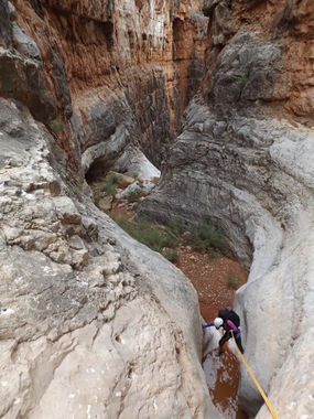
Tatahoysa Canyon
| Rating: | |||||||||||||||||||||||||||||||
|---|---|---|---|---|---|---|---|---|---|---|---|---|---|---|---|---|---|---|---|---|---|---|---|---|---|---|---|---|---|---|---|
| | Difficulty:3A IV (v3a1 IV) Raps:max ↨150ft
Red Tape:Access is Restricted Shuttle: | ||||||||||||||||||||||||||||||
| Location: | |||||||||||||||||||||||||||||||
| Condition Reports: | |||||||||||||||||||||||||||||||
| Best season: | Spring;Fall
|
||||||||||||||||||||||||||||||
| Regions: | |||||||||||||||||||||||||||||||
Introduction[edit]
Access is Restricted: See "Red Tape" below![edit]
Can be done as a long day or a more relaxed overnight trip. Water is available at the Colorado River. The hike down the Eminence Break is steep and rocky but well marked with cairns along the entire approach. The head of Tatahoysa will come into view after an hour or so of hiking to where the trail starts to level out a bit. The views are spectacular. Continue on as the trail becomes more defined and eventually crosses Tatahoysa drainage just a few yards up from the first rappel. The canyon was dry so no wetsuits were required. A full trip description is available in Todd's book Grand Canyoneering
Approach[edit]
Descent[edit]
Exit[edit]
Coalition of American Canyoneers announcement 05/15/2025: After being closed for seven years, we’re pleased to announce that access to Tatahatso Canyon and Tatahoysa Canyon off the Navajo Rim of Marble Canyon has reopened. The loop to descend Tatahatso Canyon involves some of the most beautiful scenery in Grand Canyon National Park and includes a stunning 7-mile packraft exit on the Colorado River. The loop is usually done over three days. Beta details are published in Grand Canyoneering by Todd Martin. Background: Access off the Navajo Rim was closed in 2018 as a result of visitors not following Navajo Nation rules. This in turn closed rim based access to Tatahatso and Tatahoysa Canyons. Terms and Conditions: As a condition of reopening the route, the Navajo Nation has established the following terms. Adherence to these terms is crucial for the route to remaining open. Please consider access to future canyoneers by adhering to these terms: 1 – No personal vehicles are allowed on Navajo Lands to access this route. Access is only allowed via a shuttle service provided by Grand Canyon Native Trails. One key benefit of this term is that you do not need to own a high clearance 4WD vehicle and incur the wear and tear from rough dirt roads to access the start of the route. Details: Grand Canyon Native Trails will transport the party from Page, or from the Cedar Ridge area, to the Eminence Break drop off point, and then will return to pick the party up at the designated day and time. 2 – Shuttle Pricing (one-way): $200 for the first person plus $40/person after that one-way Example: if there are six canyoneers in the group the cost will be $200 + $40 x 5 = $400 one-way or $800 for drop off and pick up. 3 – Food services: Grand Canyon Native Trails can provide food at the hike exit. The meals are quite good and it adds tremendously to the experience when hungry canyoneers finish the difficult exit to the Rim. Price = $20 per person 4 – If Cedar Ridge access is used, it’s recommended that cars be parked at a local family’s residence to provide for enhanced security. The parking fee is $20/car/night Reservations can be made as follows: Grand Canyon Native Trails Email: [email protected] Phone: 480-226-9483
Overnight and river use within GCNP requires a permit from the National Park Service.
Beta sites[edit]
 Super Amazing Map : Tatahoysa Canyon
 HikeArizona.com : Tatahoysa Canyon
 Grand Canyoneering Book by Todd Martin : Tatahoysa Wash
Trip reports and media[edit]
- http://canyoncollective.com/threads/tatahoysa-canyon.18815/
- https://www.facebook.com/media/set/?set=a.1181534758533629.1073741965.100000313473011&type=3
- http://adamhaydock.blogspot.com/2017/09/tatahoysa-canyon-grand-canyon-national.html
