Tenmile Creek (Upper)
| Rating: | |||||||||||||||||||||||||||||||
|---|---|---|---|---|---|---|---|---|---|---|---|---|---|---|---|---|---|---|---|---|---|---|---|---|---|---|---|---|---|---|---|
| | Raps:4, max ↨170ft
Red Tape:No permit required Shuttle:Required 25 min | ||||||||||||||||||||||||||||||
| Location: | |||||||||||||||||||||||||||||||
| Condition Reports: | 21 Jul 2024
"This is a fun canyon for its ease and the beautiful views and nice waterfalls. There would be many more potential waterfall rappels that must be byp |
||||||||||||||||||||||||||||||
| Best season: | Jul-Oct (avg for this region)
|
||||||||||||||||||||||||||||||
| Regions: | |||||||||||||||||||||||||||||||
Introduction[edit]
Tenmile Creek is a beginner friendly class C canyon located by Hume Lake in Sequoia National Park. This is a dam release canyon so it is important to call ahead to determine the flow. The Hume Lake Ranger District can be reached at 559.338.2251. (Note: the ranger at the dam was confused when we called to ask about release. We were informed that it's usually done in the spring when the snow melts; be aware that this call might not be very helpful.)
Flow: The dam at Hume has to release about the same amount of water as comes into the lake from Ten Mile Creek and Long Meadow Creek. Ten Mile creek is the primary water source and it is quite small. They only have high flows in the spring and in some years early summer. If you drive to the lake you can stop at Ten Mile Creek to check the flow before entering the canyon.
-Shuttle parking: 36.817305 -118.888913
-TH parking: 36.803968 -118.899062
-Drop in: 36.7999, -118.8925
Approach[edit]
From the dirt pullout there is a small 'trail' that leads down the slope. It is not the easiest trail to follow, but as long as you continue straight down (SE) you will eventually hit the creek.
Alternatively, just drive to the south side of Hume Lake on Sandy Cove Rd and park near the dam. You can drop in near the dam, or you can cut off some distance by walking the dirt road that follows the creek. A short ways past a large wide spot, the road turns away from the creek. Look for use trails on the ridge just before the road turns away. It is a fairly short distance down to the creek from this road. This approach is in forest and thus shady. I have always approached from Sandy Cove Rd, so can't compare it to the south side approach. PM
Descent[edit]
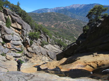
Currently (2024) there are 4 anchored rappels in the canyon. There are many spots to climb around other falls; the canyon as it is was too blank to go through these falls, and most of the pools are too shallow for adequate slides or jumps although with some scouting small slides can be done early in the canyon.
R1: LDC tree. Out of the water course; ~80 feet down to a wide ledge. Here, you can see the beginning of a small hallway sequence.
R2: LDC (cliff). Tricky to spot from a slung chockstone/boulder. This is high left on the cliff and out of the water course. ~110 feet into a wide pothole with several stones.
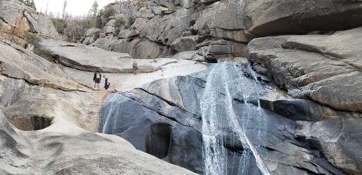
R3: Main water course. ~170 ft; 2 stage. It is a chockstone anchor that is submerged in a pool of water. Since this anchor is submerged and not visible it is important to be thorough with your inspection. Do a pull test or reach into the water and feel around the best you can. This rappel can stick on the pull. You should come off at the narrow spot before the pitons. Alternatively, you can extend this rappel (~200 feet) and have the LAPAR rappel directly to the pitons; this will allow them to belay others (after R3 is pulled) out to this station.
R4: two very rusty pitons RDC. ~100 feet into a 2 stage pool. Set length for the second pool and slide/rap off the end of the rope into the water. The climb out of pool 2 is much easier than pool 1. It's a slick climb out to this anchor in the water course and the granite in this area seemed particularly slick. Either 1) belay your climber out or 2) potentially send LAPAR down to the anchor directly from R3 (not tested). (It might be possible to bypass this rappel RDC by friction climbing up, across, and then down.)
Bypass most of the canyon by climbing around the larger falls. Towards the end when you can see the road, there is an interesting set of boulders LDC that you can climb down into. There is a little rabbit hole/cave squeeze towards the bottom of this climb.
Exit[edit]
Once you arrive to the bridge, look to your right for a small trail leading up to the road.
Red tape[edit]
DAM RELEASE CANYON!
Located in Sequoia National Park so there will be an entry fee.
Beta sites[edit]
- Beta was originally posted on sierracanyons.org (now defunct) Open PDF
Trip reports and media[edit]
Background[edit]
Locals have hiked this canyon for many years, bypassing the steepest sections. My brother in law told me about hiking it 40 years ago. I started exploring it in my free time when I was taking photographs at the Hume Lake camps. I would hike from near the dam, down to the top of the steepest section and back in a couple of hours before lunch. The first time we went all the way through, we just used meat anchors or slings and such (as best I can recall). We bypassed the lowest slot for some reason and rapped down the slabs to the right. (PM 2014)

