Tesseract Canyon
| Rating: | |||||||||||||||||||||||||||||||
|---|---|---|---|---|---|---|---|---|---|---|---|---|---|---|---|---|---|---|---|---|---|---|---|---|---|---|---|---|---|---|---|
| | Difficulty:4B III PG (v4a3 V) Raps:9-12, max ↨190ft
Red Tape:No permit required Shuttle:None Vehicle:Passenger | ||||||||||||||||||||||||||||||
| Location: | |||||||||||||||||||||||||||||||
| Condition Reports: | 1 Jun 2025
"All anchors in great shape.. Lower flow than we hoped for, but still fun.. More greenery than wed ever experienced. Made for a gorgeous day, b |
||||||||||||||||||||||||||||||
| Best season: | May-July
|
||||||||||||||||||||||||||||||
| Regions: | |||||||||||||||||||||||||||||||
Introduction[edit]
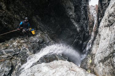
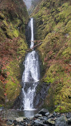
The Tesseract is a narrow and committing box canyon and gorge on an unnamed creek / faultline draining a small basin on the northwestern side of the Enigma Range (Mt Garfield Massif). The route begins with a 300’ waterfall dropping into a narrow box canyon just above 2350' in elevation. Below the box canyon the creek has a less steep pitch, but maintains a series of scenic bedrock cascades and pools down to the river bottom. While it can be difficult to navigate, there is an easy walk in after a somewhat exposed steep scramble near the top.
Water flow in this canyon generally runs low due to its small catchment size. Mid winter flow during cold and clear conditions is roughly comparable to the late spring/early summer melt stages, with peak flow likely during snowmelt in April. That combined with a low elevation approach makes access possible nearly year round depending on the local conditions.
The first sequence in this canyon is a technical multi-pitch rappel. Groups should have good rope management skills, and know how to rig a retrievable traverse line. It is recommended to bring enough rope to rig the first two pitches simultaneously. Damaging or getting a rope stuck on the first multi-pitch sequence could result in becoming trapped in the canyon, or worse, on the ledge in between the first two pitches. Abrasion minimization techniques are a must due the very sharp rock.
Avalanche Warning[edit]
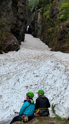
Tesseract is also prone to winter avalanches, filling up the box canyon with deep snow that can take well into the summer season to melt out. These avalanches do not happen every season, and may vary in the volume of snow deposited in the canyon. The creek flows under this snow and creates snow bridges, which become more unstable and creates risk of collapse as the snow melts. Attempting the canyon with significant snow is highly discouraged. Groups should be aware of the risk of avalanche debris, especially if the first group of the season when conditions are unknown. In mid-spring avalanche debris have been observed down to 1800' in the core of the narrow box section.
Approach[edit]
A small parking area is available at the gate to the bridge/old road that is the Taylor River Trailhead (parking option 1). If this area is full, you may have to park a few hundred yards back down the road (parking option 2). A pit toilet is available at the latter parking area (as of September 2020, this toilet is closed due to Covid-19).
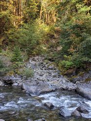
From the Taylor River trailhead, take a faint fishermans track just past the gate on the right. Work your way along the riverbank until you cross the Tesseract drainage. The fisherman's track itself disappears a short way in, and some bushwhacking is involved. Once the fisherman's trail peters out, drop down close to the river as soon as it's reasonable to do so. Travel is much easier closer to the river, rather than staying high. This route could use some maintenance at some point.
Alternatively to save time, when the Taylor River is low (usually late July through the end of summer), cross the bridge and take an easy walk about 500 yards down the trail, then cross the river. Do the same at the end of the day.
Cross the Tesseract creekbed. Heading up the hill on the north bank, the understory is generally open, with occasional thick patches of salal and vine maple. You will gain about 1,200' of elevation on the approach, and certain sections are quite steep. Starting in the late 1920's on up through the 1970's the Taylor Valley was logged, so most of the uphill approach here is in second growth timber. Along the river, there is a cautious mix of thorny salmonberry and devils club, with a friendly scattering of trillium, bleeding heart, and other floral/mossy carpets. Avoid getting too close the edge of the canyon on the hike up where you may get cliffed out. The brush gets noticeably thicker towards the top of the approach.
At around 2250' elevation you will reach the base of a large cliffband. Traverse the bottom of the cliffband towards the canyon. You'll soon scramble up onto a broad rocky platform at the top of the falls that affords access directly into the Tesseract.
Descent[edit]
DCR = Down Canyon Right
DCL = Down Canyon Left
The canyon starts off with a multi-pitch rappel into the heart of the canyon. This particular section of canyon is prone to rockfall as well as avalanches in the winter months. It is possible existing anchors could become damaged. An emergency bolt kit is highly recommended, particularly for the first group of the season. Natural anchor options here are very limited/non-existent.
Multipitch Rappel Sequence
R1: 185’ from bolts DCL to a narrow ledge DCL. At the bottom of R1, transition and rig a retrievable traverse line from two unlinked bolts to the bolted anchor for R2. Do not leave a fixed line here! The distance from the traverse line bolts to the R2 bolts is about 25', so a retrievable line at least 50' long is necessary.
R2: 150' from bolts DCL. Be aware that the rock here is very sharp. Abrasion minimization techniques are a must. This rappel will take you into the heart of the canyon. Enjoy the spectacular view from the ledge here.
(End Multipitch)
R3: 150’ from bolts on either DCR or DCL into a narrow channel. The anchor on canyon right is more easily accessible and avoids the flow better than the anchor on canyon left. Much of this rappel is free hanging.
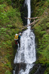
The middle section of the canyon is choked with loose boulders and a maelstrom of log debris. Most can be bypassed but there are some nuisance rappels.
R4: 50' from bolts DCL
R5: 40' from bolts DCL.
The creek funnels through a narrow section between R5 and R6, but there are no established anchors. It is possible to climb up and around this obstacle on CL.
R6: 60' from bolts DCL
R7: 45' from bolts DCL
R8: 130' from bolts DCR (located up on the wall of the canyon).
R9: 35' from a log DCR
R10: 50' from bolts DCR
R11: 30' from a log DCL. It is possible to downclimb this drop on both sides of the watercourse.
Exit[edit]
The last rappel is only a few minutes away from the confluence with the Taylor River. Exit back to the parking area on the same route as your approach.
Red tape[edit]
A Northwest Forest Pass is required for parking at the main lot with the pit toilet. Alternatively, pay a $5 day use fee in cash. As of June 2020, the fees are not being enforced here due to closed facilities from Covid-19 (be aware of closed restrooms). There are no fee envelopes available at the parking areas here. When fees are being enforced, you will need to obtain a fee envelope about 0.25 miles back down FR 56 at the Middle Fork trailhead. A forest pass is not required for parking further up the road at the gate.
Beta sites[edit]
Trip reports and media[edit]
Background[edit]
Huge thanks to Kevin Steffa who had scouted and shared the canyon with the rest of us. The first full descent was completed on June 16, 2018 by Kevin Steffa, Pt Choate, Gilly Elor, Haruka Lipscomb, and Tiffanie Lin. On an earlier trip (May 28th), another team consisting of Kevin Steffa, Sid Creutz, Gilly Elor, and Tiffanie established the bottom portion of the canyon.
