Tillicum Creek
| Rating: | |||||||||||||||||||||||||||||||
|---|---|---|---|---|---|---|---|---|---|---|---|---|---|---|---|---|---|---|---|---|---|---|---|---|---|---|---|---|---|---|---|
| | Raps:2-6, max ↨100ft
Red Tape:No permit required Shuttle:Optional 2.5mi Vehicle:High Clearance | ||||||||||||||||||||||||||||||
| Start: | |||||||||||||||||||||||||||||||
| Parking: | |||||||||||||||||||||||||||||||
| Shuttle: | |||||||||||||||||||||||||||||||
| Condition Reports: | 28 Jun 2025
"Flows are epic right now, perfect in flow raps. Replaced webbing and rap ring on R2. Root ball webbing was new so in good shape. Keyhole is def a prec |
||||||||||||||||||||||||||||||
| Best season: | Aug-Sept
|
||||||||||||||||||||||||||||||
| Regions: | |||||||||||||||||||||||||||||||
Introduction[edit]
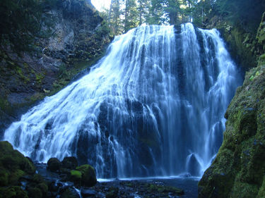
A tributary of the Lewis River on the north-northwest side of Indian Heaven. The uppermost drop is Little Niagara which is one of the most photogenic waterfalls in Gifford Pinchot National Forest. Despite being located out in the middle of nowhere, this falls is frequently visited by waterfall photographers. Tillicum Creek drains a good part of the northern end of the Indian Heaven plateau, so it sees decent flow well into summer.
Tillicum has a reputation for bad roads, but the roads were not all that bad when visited in Sept 2024. Certainly no worse than many others in the area.
Descent Options:
- Upper Tillicum: Descend R1 & R2 and exit for a short outing. Requires just a few hours. 3C I. No shuttle required.
- Full Tillicum: expect it to take most of a day. 3C III. Shuttle optional.
Approach[edit]
- It's a good idea to check the Gifford Pinchot National Forest website for the latest on road conditions in the area.
- Be aware: Google Maps lies to you in this area and may try to direct you onto non-existent roads.
Driving (North Route)[edit]
From FR 90 (Lewis River Road), turn south on FR 88 for 1.4mi. Turn right on FR 32 and follow for ~5.2mi. There are a great many potholes, some car-sized. HC vehicle recommended.
Driving (South Route)[edit]
From FR 24 near Big Mosquito Lake, take FR 8851 northwest for 3.6mi. There is a short section (0.25mi) of major subsidence along the paved section of road. Easily passed with HC vehicle as of Sept 2024. The rest of the road is fine. At the end of the pavement, turn right on gravel FR 32 for 1.6mi.
- The bridge just upstream of the parking area may be a good checkpoint for the flow. There is a campsite next to the bridge.
Hiking In[edit]
Park in a pullout at the bend in the road. Look on the south side for an obvious user trail that leads right down to the top of the falls. Approach: ~2min.
Descent[edit]
Upper Tillicum[edit]
- R1: Little Niagara Falls - 90ft. DCL on tree on the far side near the brink. This falls the banner photo of this page.
Escape is possible from below R1, taking obvious user trail up and out about 100 yards downstream / just above R2.
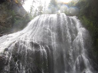
- R2: Tillicum Falls - 40ft. Anchored off a fallen log DCR. Log is part of a big logjam atop the falls. Rap line will keep you mostly out of the flow. There is a nice grotto below the falls. Walk down another 100ft where a minor tributary ("Lower Tillicum Creek") enters DCL. There is a 20ft low-flow falls barely visible just upstream.
It is possible to exit below R2 (see "Exit" below).
Lower Tillicum[edit]
Otherwise, continue 0.5mi downstream.
- R3: 50ft from thin tree high DCR. This is in the flow and quite pushy. Also possible to take a line out of the water from the same anchor.
- R4: 80ft from a set of roots DCR at the top of the second tier. (Update 2024: The roots are becoming quite rotten. May be better to move the anchor in future.)
Continue 0.45mi downstream.
- R5 Keyhole Falls - 50ft off of a tree high DCL above the mini-zen pocket. Rappel is just out of the flow.
Continue 0.25mi downstream.
- R6 Tempest Falls- 85ft into a gorgeous grotto. DCR off of a tree. This drop is especially nice.
Exit[edit]
Below R2[edit]
Head downstream a hundred yards from Tillicum Falls. Duck under two huge old-growth trees spanning the creek exit DCR up into a small area of open forest. Just to climber's left a steep tributary enters. Look for a faint unmarked user trail that heads steeply upwards on the climber's right side of the tributary. The route stays in relatively open forest with a bare minimum of bushwhacking. After about 3-5min you'll run right into an old hiking trail that runs along the north side of Tillicum Creek. Follow the trail to your right which leads right back up to the parking area.
Full Descent[edit]
Go downstream about 100 yards and exit DCR open forested slopes to locate an old overgrown road grade that will take you to FR 321. If you didn't leave a shuttle here, it's +2.5mi, 600ft hike back to the trailhead. Expect it to take about an hour.
Red tape[edit]
None.
Beta sites[edit]
NW Waterfall Survey - Little Niagara Falls
Trip reports and media[edit]
Video (Oct 2023): https://youtu.be/S52ja-45Y8g
Background[edit]
First descent of the top two falls 8/13/17: Keith Campbell, Kevin Clark, Kaitlin Rupert, Kendra Kallevig-Childers, Joe Kellett, and Mark Meyer. First Full descent 8/11/18: Ryan Ernst and Haruka James Clay Lipscomb

