Tin Roof Canyon
| Rating: | |||||||||||||||||||||||||||||||
|---|---|---|---|---|---|---|---|---|---|---|---|---|---|---|---|---|---|---|---|---|---|---|---|---|---|---|---|---|---|---|---|
| | Difficulty:3B III (v3a2 III) Raps:2-4 rappels, max ↨50ft
Red Tape:No permit required Shuttle:None Vehicle:4WD - High Clearance Rock type:Coconino Sandstone, Basalt, Limestone | ||||||||||||||||||||||||||||||
| Start: | |||||||||||||||||||||||||||||||
| Parking: | |||||||||||||||||||||||||||||||
| Condition Reports: | 17 Aug 2024
"Canyon itself is 3 stars but the access to the upper reaches of wet beaver is 4. Only two raps were needed to descend. 25 ft and a 10+10 that was fidd |
||||||||||||||||||||||||||||||
| Best season: | Spring Summer Fall
|
||||||||||||||||||||||||||||||
| Regions: | |||||||||||||||||||||||||||||||
Introduction[edit]
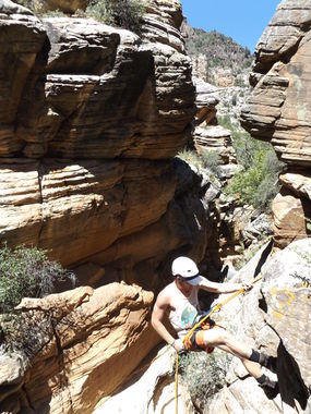
A beautiful and fun 4x4 drive through some nice meadows and pine forest leading you into the Wet Beaver Wilderness Area. The canyon has four rappels, numerous down climbs, swims, wades, scrambles, Quadi Mundi and some nice sections of narrows. Access is best coming from the 618 road to 214 (cedar flats) Recent road improvements cleaned up 214 immensely. 214 from the Stonman lake side is ridiculously rough and slow going.
Approach[edit]
From the car park hike southwest for 0.6 miles down a moderate slopping hill to drop into the canyon.
Descent[edit]
The descent is a little over 1 mile to the confluence of Tin Roof and Wet Beaver Creek. It appears we were the first descent as we had to build anchors at every drop. Head right up canyon for another 1.1 miles through a very scenic and remote section of Wet Beaver Creek consisting of several swims through crystal clear pools and narrows, a few springs and some cliff jumping. Its possible an overnight camp in Beaver creek would be best if you want to take your time otherwise getting an early start from the car would be wise. We camped at a nice campsite with a fire pit along Beaver creek and completed the loop the following day. We also ran into a family of Coati's with several babies in tow.
Exit[edit]
You will need to scramble up to the left of the first dry fall and then just right of the second with a fairly exposed section that some may want a belay for. Then simply head up the drainage with a few more small climbs bits to the top and your car. The exit is relatively free of brush just lots of scrambling through basalt boulders.
Red tape[edit]
Beta sites[edit]
Trip reports and media[edit]
Background[edit]
First Descent by Jay Wisocki

