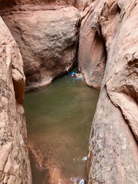
Trail Canyon
| Rating: | |||||||||||||||||||||||||||||||
|---|---|---|---|---|---|---|---|---|---|---|---|---|---|---|---|---|---|---|---|---|---|---|---|---|---|---|---|---|---|---|---|
| | Difficulty:3B III PG (v4a2 III) Raps:2, max ↨59ft
Red Tape:Permit required Shuttle: Vehicle:Passenger | ||||||||||||||||||||||||||||||
| Location: | |||||||||||||||||||||||||||||||
| Condition Reports: | 28 Mar 2025
"A lot of water though most of it avoidable, two pools were unavoidable for our group and we got wet up too neck deep briefly. 60ft rappel is anchored |
||||||||||||||||||||||||||||||
| Best season: | Spring; Summer; Fall
|
||||||||||||||||||||||||||||||
| Regions: | |||||||||||||||||||||||||||||||
Introduction[edit]
One of the best in Northwash. If you can stem a 20 foot width, you can stay dry in normal conditions. This is a real "R" canyon.
Approach[edit]
From the carpark a prominent butte of red sandstone is visible due west with the Henry's in the backdrop. The head of the canyon, and drop in, is just in front of this butte. Leaving the highway, be sure to take the right side for the Middle Fork and not the more obvious streambed on the left (South Fork). Take the Middle Fork to the confluence with the North Fork. Stay left in the Middle Fork another couple hundred feet until the smooth slickrock comes into view on the right. Go up the slickrock, gain the ridge and stay on it until you are forced into a wash veering right. Stay in the wash a short while. Half way up you are in a wash and going straight over a small saddle that drops you in. There was webbing on a bush indicating others have gone this way. Big mistake. This cuts off about 1/2 of the technical section, below the rappels but above the mandatory swimmer (in high water conditions). Instead, go left up a ramp with a crack at 37.88800, -110.58303 and stay on the ridgeline for another 1/2 mile to the obvious head of the canyon.
Descent[edit]
For the first 80% of the canyon, high-stemming and silo crossings are optional, but great practice if you are striving to do the X slot canyons. There are a few high and wide X-rated silo crossings and high body bridge opportunities. The final 20% is the narrowest. If you can stay on the bottom here, then it is possible to do this canyon without any R moves. To go high here is really what makes it an R. The walls are very narrow up to 30 feet so you have to get up high in a very narrow space and sustain the high-stemming to get over the crux pinch point. A 150 pound man with average build is about the cut off for being able to stay low.
Exit[edit]
Red tape[edit]
Permits[edit]
Due to a high volume of search and rescue incidents, the Garfield County Sheriff's Office now requires all individuals to obtain a FREE PERMIT before entering this canyon. Entering without a valid permit may result in a Class B misdemeanor.
For more information and to obtain your permit, visit: https://www.brycecanyoncountry.com/permits/
Beta sites[edit]
 Climb-Utah.com : Trail Canyon - Trachyte Creek
 RoadTripRyan.com : Trail Canyon
 CanyonCollective.com : Trail Canyon
 Super Amazing Map : Trail Canyon
 AmericanSouthwest.net : Trail Canyon
Trip reports and media[edit]
 Candition.com : Trail Canyon
04.16.2018: High water. One full swimmer. Three other swimmers could be done at waist-chest level with some acrobatics. To avoid water, high stemming most of the narrows. Total time 5 hours for 2 people. 1.5 hour approach due to two wrong turns. 3 hours descent. 0.5 hour exit. Wetsuit not recommended.
