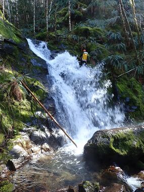
Triangulation Creek
| Rating: | |||||||||||||||||||||||||||||||
|---|---|---|---|---|---|---|---|---|---|---|---|---|---|---|---|---|---|---|---|---|---|---|---|---|---|---|---|---|---|---|---|
| | Raps:7-11, max ↨65ft
Red Tape:No permit required Shuttle:Required Vehicle:High Clearance | ||||||||||||||||||||||||||||||
| Start: | |||||||||||||||||||||||||||||||
| Parking: | |||||||||||||||||||||||||||||||
| Shuttle: | |||||||||||||||||||||||||||||||
| Condition Reports: | 8 Mar 2025
"Likely the only group in this canyon since the first descent in 2018. It was long but enjoyable with a couple fun rappels and took our time. Might be |
||||||||||||||||||||||||||||||
| Best season: | Spring
|
||||||||||||||||||||||||||||||
| Regions: | |||||||||||||||||||||||||||||||
Introduction[edit]
Deep in the Tillamook State Forest lies rarely seen and rarely descended Triangulation Creek. With multiple access points, and multiple side falls this area has several options for exploration, but has a fairly high pay to play for most folks and high clearance vehicle is preferred. Flow will be a trickle by the beginning of summer so catch it early. On the shuttle make sure to stop at Triangulation Point for a 360 Degree view, also a common destination for OHVs.
Approach[edit]
Depending on logging operations some options for getting into the area may be blocked. Known routes into the area include Cedar Creek Road that starts at Jones Creek Campground, Cedar Butte Road near Keenig Creek Campground, and Kilchis River Forest Road out of Tillamook. Once in the area some logging operations may also effect road conditions. At the 5-Way intersection marked on the map you can drive West and shorten the approach instead of going up to Triangulation Point but this was a muddy mess in March 2025 and then you miss the nice view at the top. From the parking location follow the old road grade down around the first turn, shortly after find an easy spot to head down off the road into the trees. The approach is through relatively open forest sometimes following game trails, some times crossing road grades. If it gets steep you are too far DCR.
Descent[edit]
- R1: 50ft of rope from tree DCR. Ghosted, no anchor left.
- R2: 65ft of rope from tree DCR. Webbing on tree.
- R3: 40ft of rope from tree across creek. Ghosted, no anchor left. Short drop easy to downclimb/avoid on either side.
- R4: Ropebag Falls: 60ft of rope from tree 25ft back from lip DCR. Webbing on tree.
Immediately below R4 are 2 downclimbs.
- R5: Rooster Tail Falls: 55ft of rope from tree DCR. Ghosted, no anchor left.
- R6: Triangulation Falls. Two tier. First descent team did as a single anchor we found it better as two.
- R6a: 30ft of rope from tree DCR. Webbing on tree.
- R6b: 45ft of rope from trees/shrub DCR. Webbing on tree. It's possible for block to get stuck in a groove in the rock, throw pull side DCR to avoid.
- R7: Bobsled Falls. This is a multi-tiered dropped best split up into 4 rappels for easier pull and line of sight.
- R7a: 50ft of rope from tree DCL. Webbing on tree. Drops you into a slot that could be a hydraulic at high water but the rappel is a ramp into the pool.
- R7b: 60ft of rope from large tree wedged in the rocks at water level. Webbing on tree. There is a small drop at the bottom of the pool that can be downclimbed, slid, or extend rappel.
- R7c: 30ft of rope from large rock DCR. Webbing left on rock. This rappel goes down a horizontal chute to a 90 degree turn.
- R7d: 50ft of rope from tree across creek. Ghosted, no anchor left. Multi-tiered ramp.
Exit[edit]
After Bobsled Falls follow the creek down to the confluence with the Kilchis River. It's a fairly easy creek walk in most places. Cross the Kilchis River and climb up the bank to where you parked your car.
Red tape[edit]
None.
Beta sites[edit]
- https://karl-helser.com/triangulation-creek-canyoneer-3-31-18/
- https://karl-helser.com/triangulation-creek-canyoneer-6-3-18/
Trip reports and media[edit]
https://youtu.be/dwBeytduBss March 2025
Background[edit]
First descended in March 2018 by Keith Campbell, Karl Helser, and Brad Noren.
