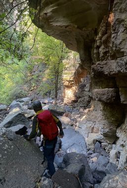
Turkey Tail Canyon
| Rating: | |||||||||||||||||||||||||||||||
|---|---|---|---|---|---|---|---|---|---|---|---|---|---|---|---|---|---|---|---|---|---|---|---|---|---|---|---|---|---|---|---|
| | Difficulty:2A II (v1a1 II) Raps:0-1, max ↨50ft
Red Tape: Shuttle:None | ||||||||||||||||||||||||||||||
| Start: | |||||||||||||||||||||||||||||||
| Parking: | |||||||||||||||||||||||||||||||
| Condition Reports: | 29 Dec 2024
"We took the longer route and skipped the rappel by going LDC. Lots of brush and debris in the water course. |
||||||||||||||||||||||||||||||
| Best season: | Oct-May (avg for this region)
|
||||||||||||||||||||||||||||||
| Regions: | |||||||||||||||||||||||||||||||
Introduction[edit]
Another wild canyon off the west rim of Oak Creek which is mostly non-technical but has one optional rappel. Can be done as a loop by parking off the 89A.
The highlight of this canyon is The Grandfather's Cave which can be visited on the hike out of the canyon.
Approach[edit]
Take Harding Springs Trail to the rim. Traverse over to FR 09456F and follow it a short distance until a faint path merges on the right. Descend and enter via this drainage, or continue following the trail to the ridge if heading to the outlook. From the ridge trail you can easily drop down into the canyon just before R1(a).
The ridge outlook has views across canyon into West Fork and is worth checking out if you have the time.
For a shorter variation of the canyon, enter the first drainage prior to reaching FR 09456F.
Descent[edit]
Both entrance drainages include an optional rappel.
R1(a): 50’ off rock pinch down semi-poor quality conglomerate, or leave the drainage and find somewhere to bypass this drop RDC.
R1(b): 20’ rappel or advanced downclimb, or bypass somewhere LDC.
Shortly after the optional rappels, the two drainages will merge. Remainder of the canyon consists of mellow downclimbs and a few pretty sections of carved sandstone.
Follow KML to Grandfather's Cave.
Exit[edit]
Follow the drainage under the bridge and back to your vehicle.
