Twin Falls
| Rating: | |||||||||||||||||||||||||||||||
|---|---|---|---|---|---|---|---|---|---|---|---|---|---|---|---|---|---|---|---|---|---|---|---|---|---|---|---|---|---|---|---|
| | Raps:4 + 1 jump, max ↨140ft
Red Tape:No permit required Shuttle:None Vehicle:Passenger Rock type:granite, basalt | ||||||||||||||||||||||||||||||
| Start: | |||||||||||||||||||||||||||||||
| Parking: | |||||||||||||||||||||||||||||||
| Condition Reports: | 23 Sep 2025
"Thanks to whomever put the new rings / anchors in. It made the pulls buttery smooth. Pulled R4 from the bottom of R4 - as opposed to from across the w |
||||||||||||||||||||||||||||||
| Best season: | Aug-Sept
|
||||||||||||||||||||||||||||||
| Regions: | |||||||||||||||||||||||||||||||
Introduction[edit]
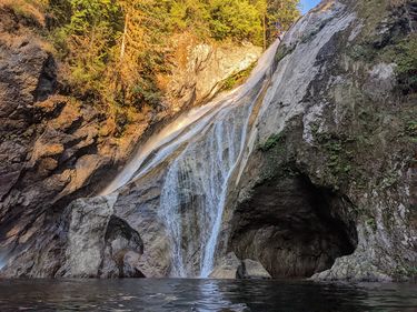
Despite the name, 5 distinct waterfalls reside in this beautiful, deep, carved canyon. Although short, this canyon makes up for it with memorable rappels, a multitude of jumps ranging from 5 to 55 feet, clear water, deep pools, good afternoon sunshine and if you can reach it, a 40 foot slide.
Waterflow[edit]
The Alice Creek water gauge is situated upstream of Twin Falls and provides an excellent data source.
35cfs is the approximate flow below which Twin Falls is normally run. Note the canyon doesn't drop below moderate-high, and maintains aspects of a5 grading, specifically: "Current strong enough to affect a swimmer’s path.".
Approach[edit]
Park at Twin Falls Parking Lot, situated just off junction 34 of I90. Hike the well maintained trail for 1.2 miles until just BEFORE you cross the wooden footbridge across the canyon. DO NOT CROSS THE BRIDGE... (unless you want to take some photos of the canyon below. Instead, deviate from the trail and hike up an obvious user trail up through steep trees and ferns. When you reach the top of the ridge, the trail continues right, along flat ground. Follow this until you come to the top of a large cliff. You will be able to hear and see the river below. Look for a webbing anchor around a tree. If you see it, you have arrived at the start of this epic canyon. There is plenty of room here to suit up and perhaps inhale a Clif bar or 2.
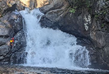
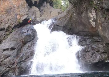
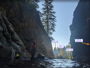
Water level reference pictures are of R2. This is visible from the hike-in shortly after leaving the official trail.
Descent[edit]
R1: 130' from a tree into the canyon. It is not the first webbing anchor you see (this will drop you at the bottom of R2); it's a tree on the left at the very edge of the cliff.
- Option 1: Recommended for the easiest pull, rope management, and group efficiency. Rappel 105' down to a ledge with room for two. Jump 20' from the ledge. There is also a ledge 5' lower.
- Option 2: The no jumping option. Rappel all the way to the water for a deep water disconnect. Swim to the opposite side and pull the rope from the rock outcropping. The rope falls into the pool with a current so there is a risk of rope entanglement underwater.
- Option 3: If you like big jumps (and you cannot lie), rappel down 75' and disconnect on the big shelf, jump 55' into the deep pool below. Note: there is a large boulder in the pool that one cannot see from the 55’ jumping spot. Make sure you know where to jump if you choose this option.
In all cases, from the pool swim DCR to a nice ledge to climb out onto. (Don't jump if flow is strong at all as there is an undercurrent + you could get pulled over the next falls).
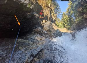
R2: 70' off of bolts DCR: This is the crux of the canyon. Rappel 60' to a ledge that is 5' above the pool, staying DCR out of the flow. Use the redirect 10' below the anchor on the underside of the overhanging face. A long quickdraw has been left here. Even on the lowest flow days, it is unrealistic to rappel in the flow as it is very concentrated on the first tier. Pull the rope from the ledge that is 5' above the pool. Two people can stand on the ledge. Jump 5ft into the pool and swim hard DCL to cross the central current, and exit at the boulder field (extremely slippery rock!).
Optional Jump: swim across the pool on the right side to the rock outcropping. Jump 10' from it and continue your momentum to swim across the current.
Note: In either case, swim further left than you think to counterbalance the push of the current. The hanging pool at the 3rd drop can have wood and contain a massive boil that is unlikely to survive in all but the lowest flow conditions.
Early Exit: there's a use trail at the back of the boulder field which leads steeply up to the official trail above.
R3: 50' from bolts DCL: In higher flow, a dry option bypasses the middle pothole pool. Use the double bolt webbing anchor, high on the canyon wall DCL. This leads down to a ledge above the large pool, from which the rope can be pulled. Jump 10' into the pool.
In lower flow, you may want to opt for the single bolt anchor on the underside of the big boulder. This line allows you to rap into the pothole and then down the next drop. This drop can also be jumped or slid as the pool is some 20ft deep below. Beware that the current in the first pothole is pushy and once you are in the big pool after the 2nd falls you have to swim hard DCL to avoid being pushed into a huge alcove DCR.
J1: Jump 15' from the central rock into the pool directly under the footbridge. There is a massive tree trunk lodged in the pool that is easy to avoid. It's a good ledge to launch from, which makes clearing the underwater shelf near the waterfall straightforward. This drop could be rappelled either with a meat anchor or a natural anchor.
At lower flows it's relatively easy to swim this pool staying DCL to an eddy pool and climb out. However, due to the exposed nature of this swim, a single bolt anchor was placed on the back alcove wall (next to the little waterfall that comes into the pool from DCR). This allows you to swim on rappel to the safety of the climb out ledge DCL. Please note that swimming while attached to a rope is dangerous. As the rope goes tight the current can start flowing over the top of you, and force you under water.
There's is a small rock outcrop halfway DCL, which makes regrouping and strategizing the approach to the edge easier.
R4: 140' DCL off of a 2 bolt anchor. Please DO NOT add any webbing to this anchor as it is in direct line of sight of the viewing platform for hikers and phographers. Great care was taken when placing the bolts so as to make them virtually invisible from the trail. Bring 400' of rope in order to pull from the far side of the pool up on the bench that makes it considerably easier
- Option 1: The driest easiest option. From the anchor stay DCL, get into a nice fluted chute that has minimal flow, which lends itself to a nice long slide on rappel.
- Option 2: If flow is low enough, from the anchor immediately go DCR as much as you can and maintain a DCR headline by leaning hard left, with feet up and heels on the wall, rap as far as you possible can DCR. Your goal is to get on the right side of a rib about 1/3 of the way down. Once DCR of this rib, it's easier to stay DCR. Free slide from a slight ledge 40' up or lower at 25' up. The slide is high-angle but not vertical. There is a perfectly angled exit ramp into the deep pool below.
If you haven't had enough jumping yet, after pulling your rope, from the ledge DCR jump 12' into the deep pool.
Note: The bulk of the flow is extreme right in a massive crack cut out of the rock layers far DCR. It would be a death wish to go in there, but nearly impossible to go that far right as the fall line brings you DCL. It is a marvel of the force of water.
Exit[edit]
Red tape[edit]
Discover Pass is required for the parking lot. There's a machine selling day passes.
Beta sites[edit]
Trip reports and media[edit]
Background[edit]
A descent of Twin Falls is described on the old Canyoneering Northwest website, but is not dated.
