Unicorn Creek
| Rating: | |||||||||||||||||||||||||||||||
|---|---|---|---|---|---|---|---|---|---|---|---|---|---|---|---|---|---|---|---|---|---|---|---|---|---|---|---|---|---|---|---|
| | Raps:7-8, max ↨150ft
Red Tape:Permit required Shuttle:Optional 1mi Vehicle:Passenger | ||||||||||||||||||||||||||||||
| Start: | |||||||||||||||||||||||||||||||
| Parking: | |||||||||||||||||||||||||||||||
| Shuttle: | |||||||||||||||||||||||||||||||
| Condition Reports: | 4 Aug 2024
"Ran this the last 2 weeks, once for rondy and this week with friends. Anchors were rebuilt during the rondy. I took notes and updated the beta. Nothin |
||||||||||||||||||||||||||||||
| Best season: | Jun-Sept
|
||||||||||||||||||||||||||||||
| Regions: | |||||||||||||||||||||||||||||||
Introduction[edit]
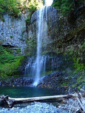
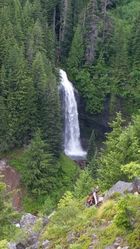
Unicorn Creek is located in the Tatoosh Range within Mount Rainier National Park, east of Paradise just off Stevens Canyon Road. It is the outlet of Snow Lake (elev. 4,688 ft), which is recharged by the Unicorn Glacier above (actually a semi-permanent snowfield). The creek descends 1,300ft in just under a mile. Columnar basalt is prevalent throughout. The character of the creek begins casually and gains momentum, culminating in the spectacular Martha Falls amphitheater just before the confluence with Stevens Creek.
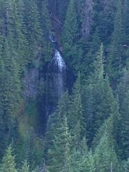
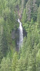
- Much of Unicorn Creek can be seen from across the canyon along Stevens Canyon Road (GPS point for pull out is 46.7707, -121.6898). This is also where the reference picture is taken.
- Watershed: 1.25mi^2. The creek drains a north-facing snowfield. The high point in the drainage is Unicorn Peak at about 6900ft elevation.
- Please see "Red Tape" below for important information on canyon access.
Approach[edit]
The approach hike begins at the Snow Lake trailhead. Follow the trail to approximately 0.75mi to cross an obvious creek just past Bench Lake. Follow this downstream about 0.15mi where the official Unicorn Creek enters DCR. (This shortcut route skips the climb up over the ridge to Snow Lake and skips a 20ft nuisance rappel.) Continue 0.1mi downstream to R1.
- If you only have one car, park at the lower trailhead and hike the Wonderland Trail upwards towards Reflection Lakes and backtrack 0.25mi to the Snow Lakes trailhead along the road. Walking the road is slightly longer and there's not much of a shoulder.
Descent[edit]
Unicorn Creek[edit]
- R1: 70ft from tree DCL. In low water, it's possible to rappel 20ft and downclimb the rest.
- R2: Needs a bolt DCR to rap 25ft otherwise its a downclimb.
- R3: 50ft from boulder DCL. This is a narrow channel with strong water. At moderate flow, recommend dropping over the edge DCL beside the flow, then crossing the flow quickly to DCR.
- R4: 90ft from a boulder in the water DCR.
- R5: 50ft sloper from a tree DCL
- R6: 110ft tree DCR
- Downclimb DCL into two pools. The last pool can be slid with caution, about 15 ft.
- R7: 80ft from boulder pile DCR into a shallow pool. The lower portion is smooth so its fun to hip slide rappel.
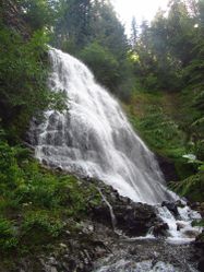
- R8: the waterfall is 70ft and the anchor is set on a log 60 feet back from the edge. Rappel line DCR is the main flow where DCL is a gentle shower.
Immediately below R8, the Wonderland Trail crosses Unicorn Creek on a log bridge, providing a possible exit. You will probably have an audience of hikers here so try to look cool.
Martha Falls (optional)[edit]
If interested in running Martha Falls, the last drop on Unicorn Creek, it's best to exit the creek DCR at the bridge and follow the Wonderland Trail eastwards about 30ft (9m). Exit the trail and make your way downhill through the forest, paralleling the creek through/along a large blowdown area until reaching a ledge above the falls. Remaining in the creek is not recommended as it's steeply sloping and extremely slippery. Going for a tumble could be quite dangerous.
- R9: Martha Falls 150ft (46m) from tree DCR. A courtesy anchor may be recommended with the person extending the anchor for a better pull.
At the bottom, there are two options for getting back up to the trail.
- Option 1: A ramp DCL leads up through a forest to a thicket of Devil's Club. Proceed through the thicket and to the top of the last rappel (now on the west side of Unicorn Creek). Parallel the creek back up to the trail. If you stray too far to bush wackers right while exiting you will find yourself in a mess of salmonberry sticker bushes with sprinkles of devils club.
- Option 2: Continue downstream until reaching the confluence with Stevens Creek. Here, turn right and go downstream 0.2mi. Use caution as Stevens is a high-flow glacial creek with swift current with the path of the streambed changing from year to year. In July 2015, it was necessary to wade for a short distance in a couple of spots, but was possible to stay out of strong current by keeping DCR. Look for an opening between berry bushes DCR and climb up the steep bank and through the thicket about 30ft until reaching a shaded, brush-free area under the forest canopy. Continue uphill through band of mature trees to reach the trail. Total distance from Stevens Creek to the trail is less than 0.1mi. Aug 2023, the current didn't look safe. We exited early and climbed a steep loose hill. We crossed some devil's club half way up to get back on the gps exit line. It wasn't bad but I'm sure there is a better way.
- Option 3: The hillside is partially collapsed DCR, 100ft from Martha Falls, creating a steep ramp. It looks possible to set ropes from a tree above and ascend 50ft out of the canyon. This requires future testing.
Exit[edit]
From the bridge crossing Unicorn Creek, follow the Wonderland Trail ~0.5mi back to the Stevens Canyon Road.
Red tape[edit]
Entrance Fee[edit]
Mt. Rainier has an entrance fee. [1]
Timed Entry System[edit]
Mount Rainier will be instituting a "pilot" timed entry system from Memorial Day-Labor Day, 2024. Some key points:
- No reservation is needed if you arrive before 7am.
- There is no limit on how long you stay.
- Each vehicle must have a unique timed entry ticket, and must enter during that 2 hour window.
- Reservations for entry are through recreation.gov, and timelines for when they open are on the website.
Any canyons along the Paradise/Stevens Canyon corridor need to be planned in advance. July trips need to be planned by April 1. August trips by May 1. Either plan on one vehicle only, or have at least two members of your team identified (and plan to be in separate vehicles). Alternatively, arrive early and enter the park before 7am.
Beta sites[edit]
 Super Amazing Map : Unicorn Creek Canyon
 CanyoneeringNorthwest.com (archive.org) : Unicorn Creek
- http://www.waterfallsnorthwest.com/nws/falls.php?num=3177
Trip reports and media[edit]
Background[edit]
The final plunge of Martha Falls (the 150 ft rappel) was descended by Robert Cobb, Joe Bugden, and John (??) in 2005.
