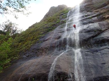
Vista House Creek
| Rating: | |||||||||||||||||||||||||||||||
|---|---|---|---|---|---|---|---|---|---|---|---|---|---|---|---|---|---|---|---|---|---|---|---|---|---|---|---|---|---|---|---|
| | Raps:4, max ↨270ft
Red Tape:Access is Restricted Shuttle:Required 10 min Vehicle:Passenger | ||||||||||||||||||||||||||||||
| Location: | |||||||||||||||||||||||||||||||
| Condition Reports: | 30 Apr 2017
"extracts from Facebook posts, click link for full details (privacy restrictions may apply). " The descent route, as originally estimated by the Ro |
||||||||||||||||||||||||||||||
| Best season: | Spring
|
||||||||||||||||||||||||||||||
| Regions: | |||||||||||||||||||||||||||||||
Introduction[edit]
The Vista House Creek is an unnamed drainage directly below the Vista House located in Crown Point State Park. The last waterfall is the most impressive drop touting at 270' foot rappel. It is visible from I-84. This drainage is not a big one and the flow largely dries up by early to mid-summer.
While rappelling is not illegal in Crown Point State Park, the park manager has closed access to the areas below the Vista House due to safety concerns/accidents from other "extreme sports." The exit towards Mirror Lake also involves crossing the RR tracks (private property).
Please consider these restrictions prior to running this canyon.
Approach[edit]
Park at the Vista House. It is recommended to avoid drawing attention by changing into your wetsuit after dropping into the creek.
Descent[edit]
R1: 100ft from shrubs DCR
R2: 50 ft from small tree DCR. It can be bypassed by downclimbing from a small stream from DCR
R3: 30 ft from tree DCR
R4: 270 ft from shrubs DCR. A courtesy anchor is recommended for all but LMAR.
Exit[edit]
The fence near the railroad tracks is used to protect trains from rockfall.
Options:
- Make your way west along the tracks and cross on an old road just west of Mirror Lake (see map). (Be aware that this is an active freight line and trains come barreling through here with little-to-no warning. Walking on the tracks is also trespassing, so make your crossing short & sweet. This is not a good place to linger or go for a walk.) Follow along the south side of I-84 toward Rooster Rock State Park. There is a parking area directly off the exit ramp (eastbound I-84) providing access to a boat ramp on Mirror Lake. If the gate to the boat ramp is closed, you can park on the shoulder. You do not need to enter the park proper or pay a fee.
- The same track at the west end of Mirror Lake can be followed south. While not shown on the map, it climbs and switchbacks up to eventually meet the parking area at the Women's Forum viewpoint at Chanticleer Point. This is another option for a shuttle. (Use extreme caution if hiking the Historic Columbia River Hwy back to the Vista House as there is little to no shoulder.) Route gains about 800ft elevation.
- If you're an experience bushwhacker, make your way west along the base of the cliffs, circle around the great formation of Alpenjager and grovel your way up a steep dirty gully (full of trash thrown down from above over the years) back to the west side of the Vista House. Not recommended if wet.
Red tape[edit]
The area below the Vista House is off-limits due to safety concerns/accidents from other "extreme" sports. Also: try to minimize walking along train tracks which is trespassing.
Beta sites[edit]
Trip reports and media[edit]
Background[edit]
The first known descent of Vista House Creek was by Luca Chiarabini, Michelle Nilles, Jake Huddleston, and Tiffanie Lin on April 30, 2017.
Ice climbers ascend & rappel the big falls during rare winter freezes in the Columbia Gorge.
