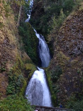
Wahkeena Creek
| Rating: | |||||||||||||||||||||||||||||||
|---|---|---|---|---|---|---|---|---|---|---|---|---|---|---|---|---|---|---|---|---|---|---|---|---|---|---|---|---|---|---|---|
| | Raps:3-4, max ↨200ft
Red Tape: Shuttle:None Vehicle:Passenger | ||||||||||||||||||||||||||||||
| Location: | |||||||||||||||||||||||||||||||
| Condition Reports: | 2 Sep 2017
"We ran this the morning of the Eagle Creek fire, so I am sure the conditions will be very different after. The anchor situation is this canyon is VERY |
||||||||||||||||||||||||||||||
| Best season: | Aug-Sept
|
||||||||||||||||||||||||||||||
| Regions: | |||||||||||||||||||||||||||||||
Introduction[edit]
This creek was overrun by the Eagle Creek wildfire in Sept 2017. While the area has reopened, please use extreme caution when descending the creek. Between landslides, fallen trees, and loose rocks, this area may be very unstable and dangerous for some time to come. The canyon may have changed dramatically. Do not rely on the beta below being accurate.
This is a very short but spectacular canyon that runs high water even in summer. Wahkeena Creek features waterfalls and scenic mini-gorge with the main attraction being Wahkeena Falls which towers at 240 ft.
The two other waterfalls upstream are Necktie falls (30 ft) and Fairy Falls (20 ft) which could be added to the descent, but are not described in this article.
Approach[edit]
Access is easy, just hike up the Wahkeena falls trail for 1/4 mile to the bridge at the bottom of the falls. This is the checkpoint for the water flow, if too high for your comfort level turn around. Otherwise, proceed up the trail following a series of switchback to the top of the promotory where a trail points to a viewpoint. Visit the viewpoint if you wish, otherwise proceed up the trail 100 yards from the junction where you find an obvious but unmarked spur trail that turn off to the right and down the hillside. Proceed on this trail as it switchbacks down the hill bordering the river and keep following this trail untill you reach an old rail and viewing platform that takes you to the very top of Wahkeena falls.
Descent[edit]
From the top of the falls use a releasable anchor around a tree or a railing pole of your choice, but make absolutely sure they are sturdy (some are not). You may also come back later to take the anchor down. Either way make sure to leave no webbing visible around the platform to avoid giving bad idea to unprepared tourists and to keep the area pristine.
- R1: 50 feet from tree at base of social use trail into watercourse (Optional - enter the watercourse from higher up canyon and scramble down without the rappel)
- R2 : The original tree anchor is gone. You can rap off a small tree on an island in the middle of the watercourse. You need about 150 feet of rope to rap down to the next anchor. Stay on rope until you clip in to the next anchor. The rocks are slippery and you will be in the direct watercourse at the base.
- R3: 180ft from crossed log and going down all the way to the bottom tier of the falls. Stay DCR and rappel down a mossy slope that allows you to be near but out of the raging water. You will get hit at the very bottom but very mild. If you go dcl (which looks easier from the top) you will get pounded by the water into a narrow flute with an entrapment issue.
- R4: 70ft from a rock pile built at the edge of the bottom tier of the falls, or the one solid rock dcr 30' behind the lip of the falls. Rappel down all the way to the bridge you visited during the hike up. Make sure that no anchor or webbing is visible from the bridge below to avoid spoiling the view for the tourists. Stay off the moss on this last rappel. Get into the waterfall.
Exit[edit]
From the bridge hike back to the parking lot following the trail
Red tape[edit]
You will be in full view of the tourists while rappeling the falls, so make sure you make a good impression. We hiked back to the parking lot wearing wetsuits, harnesses and helmets and when the park host saw us he politely asked "Did you have fun slipping and sliding?" to which we answered "Yes! It was a lot of fun!". It may still be prudent to hide the helmets and wetsuits and technical gear on the hike in, to avoid luring any unprepared tourists to follow you to the old viewing platform out of curiosity. Please note that by rappeling the falls you will NOT put the tourists in any danger, as it's practically impossible that any rocks that you may dislodge could travel so far to hit the bridge. IMPORTANT: DO NOT rappel from the very end of the viewing platform 250ft all the way down to the bridge. If you do, you WILL put tourists in danger as any rock fall will go directly over the trail.
Wahkeena Falls is one of a number of popular waterfalls located along the Historic Columbia River Highway. Be aware: unlike other parts of the country, canyoning is not widely known or recognized in the Pacific NW. Individuals climbing, rappelling, or slack-lining around such "show waterfalls" are far more likely to garner negative reactions from the general public at large. Negative reactions can lead to complaints and more rules by the local authorities. If you must descend this creek, locals suggest descending when the number of hikers will be low - e.g. early in the morning or on weekdays. Please be scrupulous about following a Leave-No-Trace ethic. Leaving brightly colored anchors can annoy waterfall photographers, irk land managers, and may encourage the inexperienced / unprepared to attempt to follow you.
Beta sites[edit]
 Super Amazing Map : Wahkeena Creek
Trip reports and media[edit]
Background[edit]
This canyon was first descended on Sept 6, 2015 by Luca Chiarabini, Adam DiPietro, and Tiffanie Lin.
