Wallace River Canyon
| Rating: | |||||||||||||||||||||||||||||||
|---|---|---|---|---|---|---|---|---|---|---|---|---|---|---|---|---|---|---|---|---|---|---|---|---|---|---|---|---|---|---|---|
| | Raps:12-16, max ↨170ft
Red Tape:No permit required Shuttle:None Vehicle:Passenger | ||||||||||||||||||||||||||||||
| Start: | |||||||||||||||||||||||||||||||
| Parking: | |||||||||||||||||||||||||||||||
| Condition Reports: | 6 Oct 2025
"Ran whole canyon, everything was good, jumps, anchors, temps in the upper canyon are quite cool now! After seeing the dry lines and now the wet line, |
||||||||||||||||||||||||||||||
| Best season: | Jul-Oct
|
||||||||||||||||||||||||||||||
| Regions: | |||||||||||||||||||||||||||||||
Introduction[edit]
A beautiful, action-packed canyon, with big raps, big jumps, easy access and multiple exits.
Water Levels[edit]
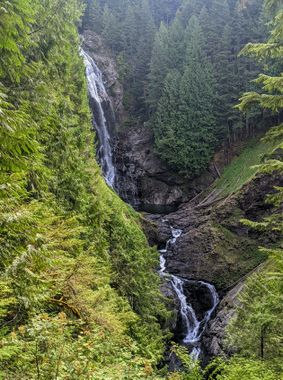
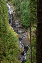
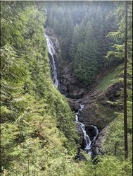
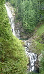
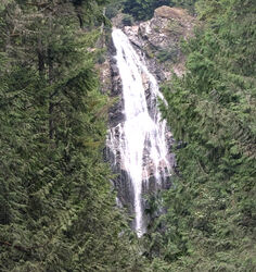
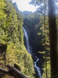
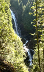
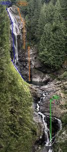
A good visual checkpoint is the Middle Falls as seen from the viewpoint along the trail.
As of 2024, Wallace River has its own dedicated flow gauge (12135000)! Please continue to upload trip reports and flow photos so we can develop an accurate correlation of cfs & conditions.
Rough estimates so far indicate:
- ~40ft³/s = very high
- ~30ft³/s = high
- ~20ft³/s = moderate (Middle Falls wet line opens around 25cfs).
- ~10ft³/s = low
It is not recommend to descend the canyon even by the "dry" routes with gauge reading above 40ft³/s unless you are prepared for strong hydraulics, bolt traverses, intense whitewater movement, and must make swims.
Approach[edit]
Hike up the trail to Upper Wallace Falls. Once you've reached the upper viewpoint, follow blue blaze markers nailed to the trees for a short distance to a gravel road. Go right on the gravel road for 500 feet to the bridge and the drop in. Involves a 1600 foot gain and takes about 1.5 hours.
Descent[edit]
As of 2022, wet line bolts have been added to a number of raps to expand the options across more flow levels.
From underneath the bridge it's a short walk to the edge of the first rap.
- R1:
- "Drier" option - DCR: 120' (or 100' to ledge + downclimb). Pair of bolts. Large rooster tail forms here when flows are mod-high or above.
- "Wetter" option - DCL: 100'. Single bolt on slab face near far left side of canyon (downclimbing the stream). Good option if the other bolts are dry.
Rappel 2 & 3 make up Upper Wallace Falls.
- R2: DCR - 10' traverse line from 2 bolts, with a slight incline up to an exposed twin bolt station. 45' Wet rappel, jump possible from lower ledges into pool.
- R3:
- Dry option - DCR: 100' 2 bolts, 8' up on wall.
- Wet option - DCL: 100' Double bolts above lip of pool. This lets you rap on the wetter DCL side of the falls, but with some careful pendulum management you may be able to rap the center line for the full flow.
- R4: 50'. DCL - 2 bolts & chain, up a rock ramp. Dry rappel into deep pool, or short-rope, or jump ~30ft from ledge just below anchor.
- R5: 55'. DCL - dry rappel from tree far left.
- DC 15’ DCR in the flow and behind the veil. If high flow, bypass DCR through vegetation.
Open creek walk for 15 minutes.
- Jump 8’ or 15' from obvious stances up on DCL.
- 8’ DCR quick rap from threaded pothole makes short and safer alternative to down-climbing or sketchy jump.
Note: At this point you're about to appear in clear view of people at the view point. It's worth staging any gear, snacking, or rearranging packs slightly upstream of here so you're of sight. There's an exit point here, up the unsanctioned trail to the view point.
R6-R8 makes up Middle Wallace Falls.
Dry option - all DCL. Note this route makes you more visible to people at the view points
- R6: 70'. From the top of the falls walk down slabs DCL until it begins to get steep. Look for a 2 bolt anchor set out of sight of the viewing area. It's a dry bushwhack rappel to ledge below.
- R7: 100'. Bolts DCL of the natural line of R6. Dry rappel, with free-hang. Beware of the very sharp edge. It has nearly cut ropes on multiple occasions. Use rope guards, minimize downward pull when descending, and inspect your rope between each rappel. Using your most static rope and rappelling in one continuous smooth motion will minimize the sawing action.
- R8: 120'. Single Ring Bolt on rock bulge near the bedrock 'ditch'. Rope can be pulled from small cave 6’ above pool, then jumped.
Wet option - all DCR. Note this route keeps you more out of sight of people at the view points.
- R6: 60', from a pair of bolts on the overhanging rock beneath the viewpoint, down to a pair of bolts on a rocky outcrop DCR. Space for 2 people at these R7 bolts.
- R7: 185', continue down the slope, over the lip, freehang via a midway ledge, then down through boulders to top of the lower DCR slopes. The further right you choose to cross the lip, the drier the experience. Actively creeping the rope is suggested.
- R8: 80', single bolt on DCR wall in small undercut rock alcove, located at the top of the stream which flows down to the pool.
Float in the pool admiring the height of the falls above you. Despite feeling like you're all the way down, this pool is still inaccessible to most people. To exit, continue downstream trending DCL.
R9 makes up Lower Wallace Falls.
- R9: 70’. Bolts on Exposed face DCL, not easy to spot until on top of them.
After R9 Sneak DCR through the falls veil if high flow, otherwise down-climb in flow.
There is a potential exit right after you get out of the pool. The obvious, but steep and unsanctioned path will lead you to the reference photo viewpoint on the main trail.
- DCC: 10’. Optional jump from central boulder into narrow landing zone pool.
- R10: 40’. Bolts DCR, dry to ledge below. This is a potential large jump. (In Oct 2022, at very low flow, a good landing zone was identified, measured as 16' deep, as shown in this photo). However guarantying enough forward momentum would be difficult.
Creek walk 20 minutes and you will reach the picnic shelter. This is an easy DCR exit.
- 15' jump immediately before picnic shelter exit, DCC.
- R11: 40’ rap from obvious threaded pothole arch DCL. Alternately an impressive 40' jump from the ledge up on DCL into deep pool. As of 2022 this landing was very deep (even in very low flows), and gaining enough horizontal distance was easy. Also possible to jump from lower ledges, but you may want the assistance of a rope from the tree branch above to access them safely.
Another bush-whack exit to the picnic shelter is possible at the R12 bolts. This is the last exit to the trail until after R14 (which isn't as effortless).
- R12: 60' DCL wet-line bolts on face (expect pummeling) or DCR dry-line bolts on slab (which can be short-roped into a surprisingly deep pool below).
- R13: 60' wet-line down center of falls from single bolt high on DCR. Dry-line DCL from bolts on top of large boulder set a way back from the edge (2024: bolts present, hangers gone). Note the water is very shallow at the foot of these falls. DO NOT JUMP!
- R14: 100' single bolt DCL. Shorter if you take the dry line. Bolt placed just past a fallen tree. The wet line looks scary but isn't that bad.
Exit[edit]
Since the hiking trail parallels the creek, there are several exits that can be taken to shorten the length of the descent. These are described in the Descent section.
After R14 continue creek-walking downstream 600ft. A smaller river joins on the right (47.87309, -121.65862). Go just past this river until you find a small use trail on the right. Follow this for a short ways until you meet up from the main trail. From here its roughly 30 minutes back to the car.
Red tape[edit]
- A Washington Discover Pass is required for the parking lot (not the Northwest Forest Pass). An electronic kiosk is available to purchase a day or annual pass.
- The area is highly managed, but yet still the site of many critical injuries & fatal accidents. It is recommended to use discretion and caution to avoid luring unprepared tourists near the top of the waterfalls. Similarly avoiding the attention of zealous park officials is worthwhile. Please consider deflecting casual questions about your activities if you are queried.
- Apparently, the trailhead used to feature signs warning that wading or swimming above the waterfalls was prohibited and punishable by a $70 fine. However, as of Sep 2014, this practice seems to have been discontinued, and no such sign has been in place for several years. Notices at the trailhead prohibit mountain biking, hunting, fishing, and walking dogs off-leash but do not mention or prohibit swimming, wading, or off-trail hiking.
Beta sites[edit]
 CanyoneeringNorthwest.com (archive.org) : Wallace River
 Super Amazing Map : Wallace River Canyon
Trip reports and media[edit]
- https://www.facebook.com/jeffbartlett/posts/10212817248444496 (VERY low flow)
- https://www.facebook.com/media/set/?set=a.10153501707866103.1073742062.669366102&type=1&l=8831879173 (low flow)
2025 Run at 18cfs https://youtu.be/fpmrHb8elJ8?si=iRzP1fzoa8mGibtn
Background[edit]
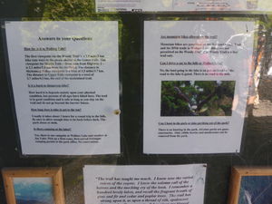
(The following is copied from the information board at the trail head)
Much of Wallace Falls State Park was acquired in 1971 from the Weyerhaeuser Timber Company. The main attraction is the Wallace River within the park. It drops from an elevation of 1,600 feet to 800 feet in less than one-half mile. Over this distance, there are technically nine falls in excess of 50 feet. The largest falls in the park, the Middle Falls, drops 265 feet. The falls, river, and lake were all named after Sarah Wallace, a strong spirited women of the Skykomish Indian Tribe who homesteaded the land between the towns of Gold Bar and Startup. While there had been multiple paths and scrambles to the Falls before, the Washington State Youth Development and Conservation Corps constructed the present trail leading to the base off the main falls in the mid 1970's. The initial development of the park was completed in the spring of 1976 and the park was open to the general public in 1977. The trail is about three miles long with scenic vistas and a picnic shelter.
The late Senator Frank Woody took a personal interest in the youth program of State Parks. He was instrumental in sponsoring legislation that provided funds for the Youth Development and Conservation Corps program. Because of Senator Woody's contribution, the Wallace Falls trail was named after him. Much of the Wallace Falls Area was first logged at the turn of the last century from about 1900-1929 by the Wallace Lake Timber Company. In the early 1880's both the steam "donkey" and small steam locomotives were invented. The donkey was a steam-driven engine with a wire rope winch mounted on a log sled, which could be dragged through the woods from site to site. When anchored to a stump, the steam donkey could be used to pull logs out of the woods to a loading site. To haul equipment and logs, many railroad grades were built throughout the area to accommodate small steam locomotives. In fact the "Old Railroad Grade" trail is one of these grades built so long ago. You can still see occasional remnants of wooden trestles and other old grades throughout the park. To get goods to market and people to the area, the Great Northern Railroad built a local station in 1901. The Skykomish Valley had several logging outfits. The largest one was the Sultan Logging and Railroad Company, owned by George G. Startup for which the Town of Startup is named. James J. Hill was a railroad tycoon who financed the transcontinental railroad. After Hill's railroad reached Seattle in 1893, he gained control of 44 million acres of land, much if it, prime timber areas. Hill later sold much of this land to Fredrick Weyerhaeuser. Weyerhaeuser purchased 900,000 acres, including what would later become Wallace Falls State Park from Hill for six dollars an acre.
For more information on the history of this area, please visit the Gold Bar Museum on Highway 2.
