Wayper Canyon
| Rating: | |||||||||||||||||||||||||||||||
|---|---|---|---|---|---|---|---|---|---|---|---|---|---|---|---|---|---|---|---|---|---|---|---|---|---|---|---|---|---|---|---|
|
| |||||||||||||||||||||||||||||||
| | Raps:12-13, max ↨98ft
Red Tape: Shuttle:Optional 40 min | ||||||||||||||||||||||||||||||
| Start: | |||||||||||||||||||||||||||||||
| Parking: | |||||||||||||||||||||||||||||||
| Shuttle: | |||||||||||||||||||||||||||||||
| Condition Reports: | 10 Apr 2025
"Orara gauge at 400 ML/Day.. Creek walking section quite slow in these conditions.. Walked / downed climbed (easy) to avoid R5. Siphon would h |
||||||||||||||||||||||||||||||
| Best season: | Oct-Apr (avg for this region)
|
||||||||||||||||||||||||||||||
| Regions: | |||||||||||||||||||||||||||||||

Introduction
Water levels
River Gauge ML/day: Orara @ Orange Grove 204068 - WaterNSW WaterInsights
400 ML/d : A4 (current in slots), walkaround P8
We encourage anyone doing Wayper to report river gauge data so more guidance can be formed.
Note: The catchment for Orara @ Orange Grove 204068 river gauge is approximately 126 square kilometres according to Water NSW. The catchment for Wayper Canyon is approximately 9 square kilometres. As a result it is possible for Orara @ Orange Grove river gauge to not accurately represent the conditions in Wayper. The Orara @ Orange Grove river gauge is located at -30.25779, 153.01140, approximately 12km downstream of the start of Wayper Canyon start.
Approach

- Park the top car at intersection of Corfes Road and Range Road (where there is a gate blocking access to the rest of Corfes Road).
- It is possible to do a car shuffle. Note that this includes walking across private land. Please respect this privilege. To drive to the end point requires driving Pine Road, which has huge water bars and requires high clearance vehicles. Note that two other roads shown on the NSW topo in the National Park, Wayper Creek Road (National Park section) and Jersey Bull Road are impassable. Drive to the gates at -30.2609, 152.9557 (marked on Google Maps as "Christ in You Fellowship"), leaving the bottom car outside the gates.
- Walking entry: Walk past gate along Corfes Road fire trail. Take left-hand turn down an unnamed firetrail and then left again (these trails are shown on Open Street Map apps but not the NSW Government topos).
- Follow the trail past the abandoned tent camp at -30.2590, 152.9174. The fire trail becomes a disused timber-getters track that can be followed down to a side tributary of the creek at -30.2570, 152.9157. Don canyon gear here and creek-walk to P1. Or take the ridge directly down from the camp.
- There are three (or four) longish creek walks which add up to a long day. It is possible to avoid the first by going down a broad ridge direct to P1 (-30.25661, 152.92081) from the abandoned campsite, suit up on a nice beach above the jump. Stay on the ridge to arrive above P1, don't drop into the gully which cliffs out below P1
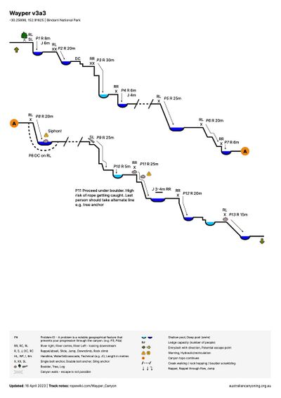
Descent
- Single bolts all the way, or slings
- creekwalking & swimming
- P1 - 8m - RL. Good jump
- P2 - 20m - RL. Bolt would not really be accessible in high flow as you have to walk down through the flow to get to it (in which case climb up into trees and abseil onto bolt)
- P3 - 35m - RR on rocks, slightly hidden behind small rock outcrop
- P4 - 6m - RL
- creekwalking & swimming
- P5 - 25m - RL on rocks. Beware of rope pinch on the pull-down, thread correctly. Or abseil last on two.
- P6 - 20m - RR on wall - descend down to just below the falls
- P7 - 5m - RR on wall - immediately after R4. Can do a technical jump out right, better to abseil down a bit and then jump because it’s difficult to get a good angle
- P8 - 20m - RL - scramble up to anchor. A narrow slot or walkaround. Pool below has messy logs and rocks, possible siphon in high flow.
- lots of down climbing and creekwalking
- P9 - 25m - creek centre sling around big log. Some sharp edges - should bleed the rope. Abseil continues to CR.
- P10 - 5m - immediately after previous abseil. Technical jump CL or CR, beware depth. No permanent anchor - a bolt would make it too easy. Can temporarily extend rope from previous abseil, check depth, then rest of party can pull rope and jump. Do not attempt to combine the rope pull for the two abseils.
- P11 - 25m - Two anchors: Tree RR, or lower down RR on big boulder (lean out to get to bolt - protect). For boulder anchor abseil through hole and out into pool (fun). Last person should go from tree anchor, as rope pull through hole will usually get stuck.
- P12 -20m-RR. Spicy in high flow
- P13 - 15m - creek left-ish on rock in the middle
Exit
There are two possible return-walk-to-start exits:
- Ascend an obvious rocky gully river right just after the last abseil. Climb a short way up this and then either side up very steep slopes to get onto a ridge, contour to the end of a logging track.
- Creek walk downstream until it is possible to exit river right then walk up onto the ridge. (Note: As of 8 Apr 2023 no known exits this way)
Note that following Wayper Creek Road from the bottom involves extensive crossing of private property, and the road is near-impenetrably overgrown. (Note: As of 8 Apr 2023 no known exits this way)
The fire trail marked on the map that is used for the gully exit is accurate. It doesn’t go any further (bad luck!).
Car shuffle exit: Walk down the creek (easy going, less than 1km) until buildings can be seen river right. Climb the stream bank into the lawned area. Please be respectful to the land owners, this is private property. Walk along the road to the gates. Contact friendly landowner to park on lawned area
Red tape
Private property on exit
Beta sites
Trip reports and media
 YouTube.com : Craving Karst, Wayper Canyon, May 2023
- Sleep When We Are Dead : Wayper April 2025