Wellman Basin (Lower)
| Rating: | |||||||||||||||||||||||||||||||
|---|---|---|---|---|---|---|---|---|---|---|---|---|---|---|---|---|---|---|---|---|---|---|---|---|---|---|---|---|---|---|---|
| | Raps:7, max ↨160ft
Red Tape:No permit required Shuttle:None Vehicle:Passenger | ||||||||||||||||||||||||||||||
| Location: | |||||||||||||||||||||||||||||||
| Condition Reports: | 4 Oct 2020
"A very enjoyable day out in this beautiful canyon with a great group of 4. This was the 2nd known descent of this canyon. Many may be put off by the d |
||||||||||||||||||||||||||||||
| Best season: | Late Summer - Early Fall
|
||||||||||||||||||||||||||||||
| Regions: | |||||||||||||||||||||||||||||||
Introduction[edit]
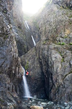
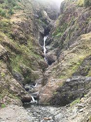
Wellman Basin is a remote canyon located on the north side of Whitehorse Mountain near Darrington. Multiple waterfalls cascade down from the small So-Bahli-Ahli glacier into Wellman Basin and might have you thinking you're in the real-life version of Rivendell (for the Lord of the Rings fans). The approach is long and arduous with an infamous bushwhack to the top, but those willing to endure it will be rewarded with a beautiful canyon that features many fun rappels and interesting geologic layers.
This beta documents just the lower section of the canyon. There are multiple forks that drain into the lower section that have future canyon potential, but as of 2020, they have not been explored due to difficult access. Don't forget to bring your camera - it's nearly impossible to take a bad picture in this canyon -- don't forget to look back up.
The canyon bottom is typically filled with snow and ice until mid to late summer. The ice leaves behind impressive but unstable ice caves and ice bridges so it is advisable to enter the canyon after most of the ice and snow has melted. Significant snow and ice may be visible from the bottom of the canyon.
Approach[edit]
Getting There
From Arlington, take SR 530 east for 24 miles (about 30mins). Turn right onto an easily missed gravel road (48.2695, -121.6722) that soon ends at a locked gate. Park at the gate making sure you are not blocking access. There is a residence on the right side of the road here, so please quiet and respectful.
From Darrington, head west on SR 530 for 3.8 miles and turn left onto the gravel road (48.2695, -121.6722).
The Approach
The approach consists of three sections:
Logging Road (2.2 miles). This is a mostly flat gravel logging road that can be walked or easily be ridden on a bike (highly recommended). When you encounter a split in the road at 48.2545, -121.6621, stay left. Soon you will encounter a large berm where you can walk around on the left. Continue several hundred feet further and hide your bikes in the surrounding forest. Biking will take 20-30mins, walking will take 1h+).
Forest Walk and Creekbed (1 mile, 400' elevation gain). Push through a few feet of dense vegetation to enter the forest. The walk through the forest is easy. In 5-10mins you'll reach a dry creekbed. Follow the creekbed, navigating numerous fallen logs up until you reach the the base of the falls (40-60mins).
Uphill Bushwhack (0.3 miles, 700' elevation gain). The infamous Wellman bushwhack approach. After taking a look at the canyon from the bottom, backtrack to a large boulder on creek left. Scramble up past this boulder and traverse left across the hillside, looking for a suitable spot to enter the brush. Ascend through the dense vine maple and devil's club, angling to the left slightly as you climb. Once you reach around 1,800' elevation, begin traversing to the left. Soon you'll reach a rocky outcrop with a view into the canyon below. Work your way down to the canyon floor (this section is steep and chossy, so move carefully). This section of the approach will take you 1.5-2 hours.
Descent[edit]
DCR = Down Canyon Right
DCL = Down Canyon Left
**Note on Potential Anchor Damage: This canyon sees seasonal flooding, avalanches, and rockfall, which can damage bolts and webbing. If you think you may be the first group of the season, be prepared for potential anchor damage. An emergency bolt kit and strong natural anchor skills are highly recommended. As a result of anchor damage potential, this canyon has numerous unlinked bolted anchors. DO NOT ADD WEBBING TO THESE ANCHORS! Rockfall and debris can catch on linked anchors and severely damage them. Groups should be familiar with rigging unlinked bolts.
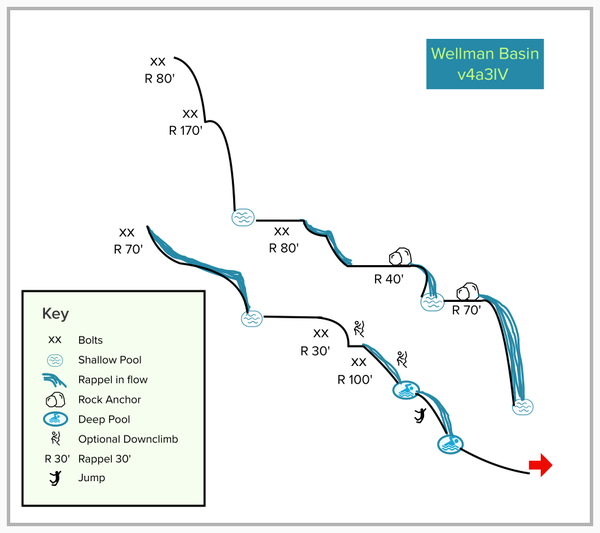
R1: DCR - This is multi-pitch rappel out of the watercourse.
Pitch #1: 80' from a bolted anchor to a small ledge that can fit 2 people.
Pitch #2: 170' from a bolted anchor.
R2: DCR - 80' from unlinked bolts. This anchor is set back away from the edge. There is a single bolt on CR to rappel out of the watercourse if desired.
R3: 40' from webbing around a boulder pinch
R4: 70' from webbing around a boulder. There are options here for rappelling both in and out of the watercourse, which could get quite intense in higher flow.
R5: DCR - 70' from unlinked bolts. The water funnels into a narrow chute here. Be wary in higher flow. It is possible to avoid the flow altogether DCL (although there is no established anchor here)
R6: DCR - 30' from unlinked bolts. This drop has been downclimbed on CL.
R7: DCR - 100' from unlinked bolts. This is a two-stage rappel. This entire drop has been downclimbed, and as of 2020, the lower pool is quite deep and can be jumped.
Exit[edit]
Proceed back down the same way that you came.
Red tape[edit]
Beta sites[edit]
Trip reports and media[edit]
Background[edit]
The canyon was first descended on Sept 21, 2019 by Kevin Steffa, Barry Specht, Doug Hecker, Haruka-James Clay Lipcomb, Jake Huddleston, and Tiffanie Lin. Our team had attempted to descend Wellman Basin on Sept 23, 2018 but the canyon and weather had different plans for us. It had rained for 3 days prior and the forecast on Sunday promised a gray but at least rain-free day. The bushwhack through dense and wet vine maple and devil's club turned out to win the award for worst bushwhack of 2018. While we made it to our drop-in point, we were tired, drenched from the wet brush, and cold from the 50F temperatures and wind that swept through the canyon. The bushwhack had taken longer than expected (4 hours) and our team made the decision to bail and subjected ourselves to the worst bushwhack of the year again -- but downhill. We had a year to forget how heinous the bushwhack was and returned in 2019. The 2019 Wellman Basin trip is a trip that our team still looks fondly back on -- the sun was out, the teamwork was smooth, water conditions perfect, and we were finally able to complete the canyon that shut us down the year prior.


