Wheeler Creek Canyoneering Canyoning Caving
|
| Rating: |
Log in to rateLog in to rateLog in to rateLog in to rateLog in to rate 2.3 (3 ratings) |
|
|
| |
Raps:0 No Shuttle:Optional |
|---|
| Location: |
|
|---|
| |
|---|
| Condition Reports: |
(log in to submit report)
|
|---|
Weather: |
|
|---|
| Best season: |
July-Sept | winter | | spring | | summer | | fall |
|---|
| Dec | Jan | Feb | | Mar | Apr | May | | Jun | Jul | Aug | | Sep | Oct | Nov |
|
| Regions: |
|
https://web.archive.org/web/20210527212206/www.canyoneeringnorthwest.com/WheelerCreek/Wheeler_Creek.php
42.8522, -122.0120https://ropewiki.com/images/b/bd/Wheeler_Creek.kmltopo
GPS data automatically extracted from [], please visit their site for more detailed information.
Automatic GPS data extraction NOT allowed, please visit [] to download GPX.
Reference photos
1 Sep 2014:
Low. Not as fun, but should be safe even for beginners (class B/C = a3).
These reference pictures are used in the
Waterflow analysis to predict current conditions. More reference pictures will produce a more reliable prediction.
(log in to submit reference picture) | Welcome! Canyons in the Pacific Northwest can be different from those you might be used to. Be ready for unlinked bolts, retrievable traverse lines, and challenging aquatic environments. For more on local practices, and the best way to get started in the region, check out the WCC Safety page.
- Unlinked Bolts - groups should be comfortable rigging unlinked bolts, either temporarily linking them for all but the last person, or using a passive redundancy method. Most importantly, if you find two bolts side by side that are unlinked, do not add webbing to them. Linking bolts designed to be unlinked will likely cause damage during seasonal floods.
- Traverse Lines - many canyons are rigged to allow traverse line access to an exposed anchor station. This should be done using self-belay or team belay techniques. Do not leave fixed lines in the canyons.
- Challenging Environments - the highly aquatic nature of PNW canyons can surprise many. Cold temperatures, slippery rocks, loud waterfalls, and strong currents all lead to unexpected problems. Do not underestimate the need for strong team work and technical proficiency. Belays are frequently not possible. Unattended gear will sink or float away. Sliding and jumping is the cause of most major injuries, so it's critical to effectively communicating water depth & submerged hazards.
|
Introduction[edit]
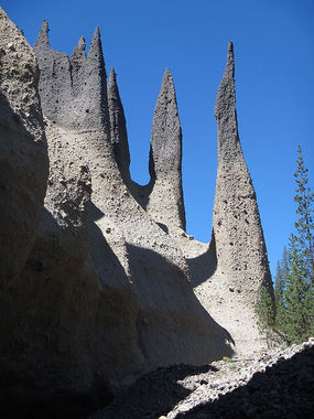
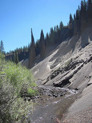
Non-technical creek in the Pinnacles area of Crater Lake National Park. Traversing the canyon provides quite a different perspective from most visitors who peer down at the pinnacles from viewpoints on the canyon rim. One of the most bizarre / unique things about visiting this canyon are the fist-sized rocks floating by in the creek. It's pumice!
Approach[edit]
Drive all the way down to the viewpoint at the end of the Pinnacles Rd. Leave a car here and either hike or shuttle back north about 0.75mi to the point where Wheeler Creek crosses underneath the road; easy to miss. If using a shuttle car, be sure it's parked well off the road.
Descent[edit]
Cross the road and drop into the creek wherever is easiest. Head downstream, wading right in the creek. Potentially a few minor obstacles along the way, but nothing too challenging. Rope not required. The stream meanders quite a lot, so it can be easier to leave the creek occasionally to take a direct route. Into mid-summer there can be giant blocks of snow lying in the creek. Early season photos show the snow carving tunnels under the snowpack; bring a helmet and use caution.
Once past the main area of hoodoo pinnacles, note a steep forested slope DCR. Climb steeply up wherever is easiest to the south rim. You'll intersect a trail just outside the national park boundary. Turn right and follow this trail back to the lower parking area / viewpoint.
Red tape[edit]
Entrance fee to Crater Lake National Park.
Beta sites[edit]
Trip reports and media[edit]
Background[edit]
Further Explorations[edit]
There appear to be a lot more pinnacles located on the adjacent Sand Creek to the north - although this area has not been explored. A loop route is probably feasible.


 CanyoneeringNorthwest.com (archive.org) : Wheeler Creek