20.6501, -156.0970https://ropewiki.com/images/1/1e/White_Rock_Canyon.kmltopo
GPS data automatically extracted from [], please visit their site for more detailed information.
Automatic GPS data extraction NOT allowed, please visit [] to download GPX.
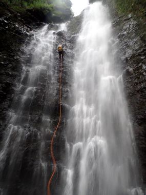
Wonderful canyon off the road near (just west of) Alelele Stream. You can see the large white rock and falls from the road as you head down towards the bridge. This is a large drainage that is dry or a trickle most days but can explode into massive flows after heavy rains and thus the character varies greatly depending on conditions, from a B to a CIII, in short periods of time. There are private property issues involving a homestead you must not cross through on your way to the drop in. Standard anchor building skills required, usually deadman, cairn, or tree anchors.
Approach[edit]
Head up the guava forest to the LEFT of the wash (looking up canyon) that runs under the bridge. Head up this ridge, following pig trails, until you get to the top of the first drainage. From there, cross over a few hundred feet and drop into the obvious larger drainage that leads to the falls.
(Approach trail on the KML is approximate, use your best judgement)
Descent[edit]
Last rappel is 230 feet, or build an anchor 30 feet below for 200 feet rappel with an easier pull.
Follow the wash to your car.
Red tape[edit]
Beta sites[edit]
Trip reports and media[edit]
Background[edit]
