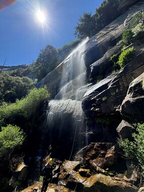
Wildcat Creek
| Rating: | |||||||||||||||||||||||||||||||
|---|---|---|---|---|---|---|---|---|---|---|---|---|---|---|---|---|---|---|---|---|---|---|---|---|---|---|---|---|---|---|---|
| | Difficulty:3B II (v3a2 II) Raps:8, max ↨175ft
Red Tape:No permit required Shuttle:Required 12 min Vehicle:Passenger Rock type:Granite | ||||||||||||||||||||||||||||||
| Start: | |||||||||||||||||||||||||||||||
| Parking: | |||||||||||||||||||||||||||||||
| Shuttle: | |||||||||||||||||||||||||||||||
| Condition Reports: | 23 Jun 2024
"Even with no idea where we wanted to build anchors, this maiden voyage only took a bit over 5 hours. Thanks to a crack of noon start :) we were done |
||||||||||||||||||||||||||||||
| Best season: | Mar-Jul
|
||||||||||||||||||||||||||||||
| Regions: | |||||||||||||||||||||||||||||||
Introduction[edit]
Wildcat Creek is a much smaller sibling of Cascade Creek and thus a good run early season or on a wet year. It sports over a dozen rappels, if you want to stay in the water all the time as the creek zig-zags its way down over many waterfalls. The descent below is much more straight down, but often is adjacent to the watercourse.
Approach[edit]
From the parking pull-off 37.72443, -119.71827, head more or less straight toward R1 at 37.72366, -119.71721, instead of following the creek from directly under the bridge has a lot of brush.
Descent[edit]
Work you way down past a short staircase waterfall and a brushy sloping trough corner (DCR) until you reach a rounded slab and can see down into the valley, including Hwy 140:
R1: 80' from a single bolt down the low angle slab staying DCR near the water, then hop over the water to several big trees.
R2: 150'? from a big tree with webbing anchor
R3: 120'? from a rock horn with webbing well DCR from the water course
R4: 175' from a huge tree DCL of the water course on the next slab pour over; the "money" drop and banner photo
R5: 80' from a pinch point with webbing, down the moderate angle slab. Follow the water course trough angling right, to an expose location at the edge of the drop-off.
R6: 150'? from two bolts on a flat rock above head level, not visible until you get there
R7: 80' from a chock stone with webbing in a chimney and up over the ridge of rock; note: there is poison oak at the bottom of the drop.
From here you need to work your way down several short downclimbs and drop-offs, through the sometimes thick brush, and all the poison oak.
R8: 90'? ghosted from a tree in the center of the dual cascading waterfalls. Use the waterfall and pools at the bottom to rinse off the poison oak oils!
Exit[edit]
Head DCL through some bushes and find the trail that takes you back to the parking area 37.72140, -119.71520 in less than 2 minutes hiking.
Red tape[edit]
Beta sites[edit]
Trip reports and media[edit]
Background[edit]
I'm really surprised that there were no signs of any old anchors. Wildcat is a little gem of a canyon run with super easy access top and bottom.
